UDOT PLANNED AVALANCHE CLOSURES!!

Forecast for the Ogden Area Mountains

Drew Hardesty
Issued by Drew Hardesty for
Monday, April 8, 2019
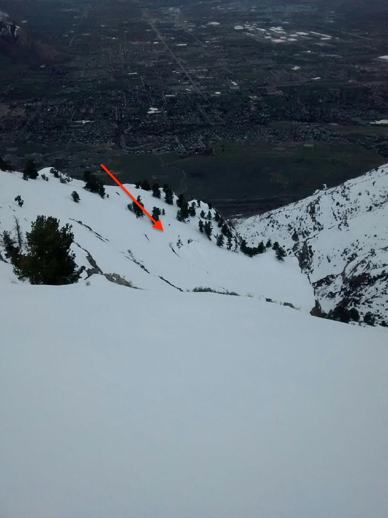
The avalanche danger for wet loose and wet slab avalanches will rapidly rise to MODERATE and may reach CONSIDERABLE with today's direct sun and scorching temperatures. Natural and human triggered avalanches are probable. When the snow becomes wet and unsupportable, avoid all steep terrain. Avoid all cornices and glide cracks as each are prone to release today.
Low
Moderate
Considerable
High
Extreme
Learn how to read the forecast here
Special Announcements

Summer is a busy time for the UAC working on our fall and winter planning, putting together the Fall Fundraiser and the Utah Snow and Avalanche Workshop (USAW), and updating our education programs. In addition, this summer we will be finishing up the website redesign project. Your donation shows you’re invested in this community all year round! You can still be part of the UAC’s success in 2019.
Consider making a donation by April 8. Thank you!

Our final podcast for the season has been released HERE. Low Danger - A Story in 5 Parts. Thanks much to our producer Benjamin Bombard and our sponsors Arva, Prival, and 2nd Tracks Sports.
Weather and Snow
Skies are clear. Winds are west to northwest blowing 10-15mph with occasional gusts to 20. Overnight temperatures are sweltering and received only the barest of refreezes. 5am temps are in the low 30s along the upper elevations and low 40s in the mid-elevation thermal belt. Any supportable crusts will be quickly "less so" with today's initial sunny skies and searing temps. We'll see high clouds that'll thicken by the late afternoon/early evening. Ridgetop temps are expected to skyrocket to near 40°F by the afternoon. Many base areas and trailheads may reach 60°F by the afternoon. All aspects and elevations will suffer damage from today's sun and heating. Whew.
The good news is that a couple powerful storms are lining up for tomorrow afternoon, effectively through late Friday that'll bring 12-18" of snow and mercifully colder temps. Mountain temps will drop back to the teens.
Recent Avalanches
None noted.
Ad
Avalanche Problem #1
Wet Snow
Type
Location
Likelihood
Size
Description
Saturday night's good refreeze and yesterday's cloud cover was enough to keep the wet activity at bay. We'll have no such luck today. Overnight lows are 8-10°F warmer that those from Sunday morning and we start with temps already in the low 40s at the mid-elevations. Snow surfaces will have only a superficial refreeze and will soften and become unsupportable much earlier than normal.
Upper elevation northerlies will have superficial wet activity today while mid to low elevations will become completely unsupportable by late morning into the midday hours.
When this occurs, you'll know it and you'll need to avoid all steep terrain, especially steep terrain above terrain traps such as creekbeds or steep-walled gullies.
Obvious signs include unsupportable snow, pinwheels (Doug Wewer pic below), rollerballs, and natural wet sluffs and slabs.
Avalanche Problem #2
Normal Caution
Type
Location
Likelihood
Size
Description
Other concerns for the backcountry traveler -
CORNICES remain a concern with tremendous heating and are large and unruly this year. Give them a wide berth along the ridgelines.
GLIDE CRACKS have been noted in the Cutler Ridge and Ben Lomond area. These glide cracks can sometimes release catastrophically (glide avalanches), pulling out the entire winter's snowpack to the ground, leaving large debris piles. Avoid being beneath these opening glide cracks. photo below of glide cracks -
PERSISTENT WEAK LAYERS formed during the equinox and now buried 3+' appear to have fully healed but still some uncertainty exists with these layers. They were most prominent on north to northwest aspects in the mid-elevations.
Additional Information
See Doug Wewer's pic of wet grains - snow melt creating liquid water dissolves the bonds between the grains. Add steep terrain and something (humans, infrastructure) AT RISK, and you have wet avalanche danger.
General Announcements
This information does not apply to developed ski areas or highways where avalanche control is normally done. This forecast is from the U.S.D.A. Forest Service, which is solely responsible for its content. This forecast describes general avalanche conditions and local variations always occur.