Forecast for the Ogden Area Mountains

Evelyn Lees
Issued by Evelyn Lees for
Wednesday, April 10, 2019
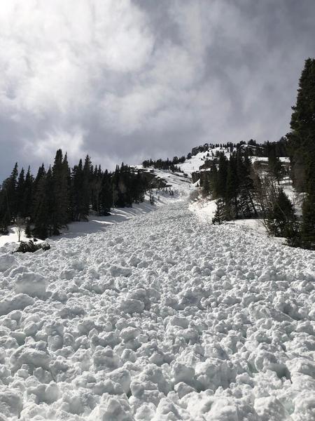
The avalanche danger is CONSIDERABLE on all mid and upper elevation slopes - natural avalanches are possible, and human triggered slides likely. The danger is MODERATE at the low elevations. Both new snow and wet snow avalanches can be easily triggered. The danger will peak during periods of heavy snowfall or where the winds pick up, and may reach HIGH with a natural avalanche cycle occurring after frontal passage.
Dangerous avalanche conditions today will require careful snowpack evaluation, cautious route finding and conservative decision making. Avoid avalanche run out zones.
Low
Moderate
Considerable
High
Extreme
Learn how to read the forecast here
Special Announcements
Daily early morning avalanche forecasts will end Sunday, April 14. We will issue early morning forecasts on Friday, Saturday, and Sunday of Easter weekend (April 19-20). Throughout the rest of April, we will issue intermittent updates with any snowfall and we will continue posting observations.

Our final podcast for the season has been released HERE. Low Danger - A Story in 5 Parts. Thanks much to our producer Benjamin Bombard and our sponsors Arva, Prival, and 2nd Tracks Sports.

Thanks so much to everyone who supported our spring fundraiser. We exceeded our goals. The UAC could not exist without your support.
Weather and Snow
Bonus powder days on the way! I'm estimating storm totals of 4 to 6” in the Ogden area mountains at the mid and upper elevations. Yesterday, prefrontal rain bands soaked the snow as high as 7,500’ before the rain/snow line dropped. Water totals from the combination of rain and snow are up to .75 inches. Temperatures have cooled into the teens and twenties, and the northwesterly winds are moderate along the high ridge lines - 15 to 20 mph, with gusts to 25 mph.
Today: the cold front should have pushed through the Ogden area mountains around 7 am, and snow rates 1 to 2” per hour are possible at times. An additional 4 to 8” of snow are expected today at the upper elevations. The northwesterly winds will increase, with 10 to 25 mph averages in mid elevation terrain, and the higher peaks averaging 25 to 35 mph, with gusts in the 50s. Temperatures will remain in the teens and 20s.
Recent Avalanches
No new avalanches reported from the Ogden area mountains.
Ad
Avalanche Problem #1
New Snow
Type
Location
Likelihood
Size
Description
Up to a 6" of new snow has fallen, and more is on the way. Expect an active avalanche day.
Early reports of a density inversion in the new snow should make new snow avalanches easy to trigger on steep slopes this morning. Depths could increase by afternoon in terrain where the front piles up additional snow or in wind drifted areas. Continuously steep terrain magnifies even small slides, allowing them to entrain snow and run long distances. A slide triggered in dry snow may change into a wet snow slide as it moves down slope today, running further than expected.
Wind blown snow drifts of will increase in depth and coverage as the winds pick up this morning with the frontal passage, and natural avalanches are possible. Signs of wind drifts include cracking of the snow and looking for smooth, rounded pillows of snow that are denser than the snow around them.
Cornices forming today are very sensitive. Stay well back from corniced edges when traveling on ridge lines - they will break back further than expected. And avoid travel beneath them.
Avalanche Problem #2
Wet Snow
Type
Location
Likelihood
Size
Description
It’s an even playing field on all aspects below about 8,500' to 9,000', with the already wet snowpack getting additional rain yesterday afternoon. Now hidden by a veneer of new snow, the old saturated snowpack is still warm and wet. So on all aspects below about 9,000’, expect any new snow slides to quickly become wet snow slides, possibly gouging into the old wet snow. Wet avalanche debris piles up instead of spreading out, and even small slides can deposit 3 or 4 feet of cement like debris against trees, in gullies or on roads. Avoid even the smallest terrain traps such as gullies or creek beds and avoid runout zones.
Wet debris from Monday's natural slide off east facing Kessler, Big Cottonwood Canyon, crossing the summer road. Nina Lorentzen photo.
Avalanche Problem #3
Gliding Snow
Type
Location
Likelihood
Size
Description
Glide avalanches are difficult to forecast as they seem to happen at unpredictable times. A good dose of rain yesterday following a long stretch of above freezing temperatures day and night are prime conditions for these avalanches to occur. Before releasing, the snowpack typically produces large, visible cracks in the snow which tell us where these avalanches can occur.
They often happen where the snowpack rests on top of rock slabs or smooth surfaces. Common places to find these cracks and glide avalanches are on the steep Ben Lomond faces. Knowing when they will occur is very difficult to forecast.
Additional Information
Spring is here and it is time to adjust our travel. Learn what to watch for during spring avalanche conditions when the snow becomes wet.
General Announcements
This information does not apply to developed ski areas or highways where avalanche control is normally done. This forecast is from the U.S.D.A. Forest Service, which is solely responsible for its content. This forecast describes general avalanche conditions and local variations always occur.