Forecast for the Ogden Area Mountains

Trent Meisenheimer
Issued by Trent Meisenheimer for
Wednesday, March 9, 2022
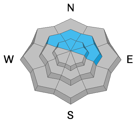
There is HIGH avalanche danger on steep northwest-to north to east-facing aspects at the mid and upper elevations. You are very likely to trigger an avalanche 1-3' deep failing on a buried persistent weak layer faceted snow. Natural avalanches are likely, and traveling in avalanche terrain is NOT recommended.
There is a CONSIDERABLE danger on all other aspects. This involves soft slab avalanches failing within the new storm snow as well as fresh drifts of wind-blown snow.
Low
Moderate
Considerable
High
Extreme
Learn how to read the forecast here
Avalanche Warning
A powerful winter storm has created very dangerous avalanche conditions in the backcountry. The avalanche danger is HIGH.
  • In effect from 6 AM MST this morning to 6 AM MST Thursday
  • For the mountains of Northern Utah, including the Wasatch Range north of I-80, Western Uintas, and the Bear River Range.
  • Heavy snowfall and blowing snow overloaded slopes with buried persistent weak layers and created widespread areas of unstable snow.
  • Human triggered and natural avalanches are likely. People should avoid travel in avalanche terrain today.
Weather and Snow
It's coming down and snowing hard! With mountain temperatures ranging from 15-20°F and winds blowing from the west-northwest at speeds of 10-20 mph, gusting into the 20's & 30's across the upper elevation ridgelines.
Overnight (past 12 hrs), the Ogden area picked up 10-18 inches of new snow containing (1.0-1.50" water).
Today, we should see continued snowfall throughout the day, with an additional 4-8 inches of new snow by sundown. Mountain temperatures will top out in the mid to low 20's °F. Winds will stay from the west-northwest and blow 10-20 mph with gusts into the 20's and 30's across the upper elevation terrain.
Recent Avalanches
As I type this avalanche forecast I bet there is a natural avalanche cycle happening now. Be sure to catch up on recent observations HERE.
Ad
Avalanche Problem #1
Persistent Weak Layer
Type
Location
Likelihood
Size
Description
We have very weak faceted snow (persistent weak layer) now buried roughly 20-30 inches deep, and this layer is actively producing avalanches (see recent activity). With more snow and an increase in the wind, this problem is only getting more dangerous.
This weak layer is currently overloaded by heavy snowfall, and I expect the avalanches to gain significant volume today. Meaning the avalanches will be getting deeper, wider, and more dangerous and could easily produce both natural and human-triggered avalanches 1-3 feet deep and several hundred feet wide. Avalanches can be remotely triggered today (meaning from a distance).
These are tree snapping, bone-crushing avalanches that should not be messed with. I would strongly encourage sticking to slopes less than 30° in steepness with nothing steep above or adjacent to you. Traveling in avalanche terrain is NOT recommended.
Avalanche Problem #2
New Snow
Type
Location
Likelihood
Size
Description
The simple fact is the new snow will be on all aspects and elevations, and I would expect it to be reactive to the weight of humans today. Avalanches that fail within the new snow will likely be 12-24 inches deep and fail as a soft slab avalanche.
Avalanche Problem #3
Wind Drifted Snow
Type
Location
Likelihood
Size
Description
The north-westerly winds did pick up overnight and are blowing 10-20 mph gusting into the 20's and 30's across the upper elevations this morning and there is plenty of new snow to blow around.
As always, watch for and avoid the snow that looks pillowy and rounded. This problem will only be compounding if you have weak snow underneath the wind drifted snow, allowing for the avalanche to be that much deeper.
Additional Information
Since it's so dangerous and the roads and traffic will be a mess. Please take a minute and check out Drew Hardesty's new blog on "Our Jan/Feb Drought Layer and PWL Summary of Avalanche Activity on This Layering for the Central Wasatch Range." HERE.
General Announcements
Who's up for some free avalanche training? Get a refresher, become better prepared for an upcoming avalanche class, or just boost your skills. Go to https://learn.kbyg.org/ and scroll down to Step 2 for a series of interactive online avalanche courses produced by the UAC.
This information does not apply to developed ski areas or highways where avalanche control is normally done. This forecast is from the U.S.D.A. Forest Service, which is solely responsible for its content. This forecast describes general avalanche conditions and local variations always occur.