Forecast for the Ogden Area Mountains

Drew Hardesty
Issued by Drew Hardesty for
Saturday, March 5, 2022
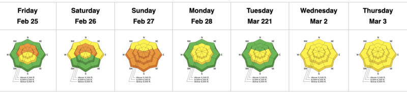
The danger will be on the rise this weekend with rapidly changing conditions.
We start out at MODERATE this morning but I expect we may move toward CONSIDERABLE tonight into tomorrow. With any spike in snowfall rates, shallow new snow avalanches on all aspects will spike as well.
Human triggered avalanches 1-2' deep on a buried persistent weak layer west to north to east facing aspects will become more likely with this additional loading this weekend. Extra caution is warranted for areas that receive the most snow.
Low
Moderate
Considerable
High
Extreme
Learn how to read the forecast here
Special Announcements
Join us on Wednesday, March 9th at the Broadway Theater in SLC for a special screening of the award-winning film “BURIED,” a feature-length documentary based on the events and circumstances surrounding the 1982 avalanche in Alpine Meadows, CA. The show starts at 7 pm. Purchase tickets HERE.


We issued a press release yesterday warning of a rising avalanche danger over the next several days...
Weather and Snow
The first in a series of storm systems brought thunder and wild apparitions of clouds yesterday, producing a trace to an inch of rimed snowflakes and graupel. Breakable crusts, variable patches of soft snow and nearly unsupportable wet snow conditions down low was enough to make philosophers out of the best of us. But throw down the books - we should be powder skiing and riding by tomorrow.
A large and slow moving Pacific storm system will be churning overhead through tomorrow evening, producing widespread snowfall throughout the state. With the center of the closed circulation currently to our west, snowfall is arriving on a light southwest flow. Winds are less than 15mph from the southwest and temperatures, mercifully, are in the low to mid-20s.
As of 5am, snowfall amounts are a 1-3" in the Ogden and Salt Lake mountains. The Provo area mountains have already picked up 6"/0.65"SWE.

A fair bit of uncertainty exists with the details of this storm system, but I expect generally light snowfall throughout the day with higher snowfall rates by early afternoon into the evening. <HINT: WATCH for changing conditions today> 2-5" can be expected just before dinner. Winds will remain generally less than 15mph with higher hourly averages along the skyline. Temperatures will drop to the low 20s by the afternoon.
Snowfall rates should increase into the overnight hours, with snowfall continuing through the day Sunday as the flow shifts northwesterly. Snow densities fall and temperatures drop to the mid/low teens. Winds should remain light to moderate. 8-14" can be expected by Sunday night.

We get a bit of a break early week with another series of storms possibly Tues-Thursday.
Recent Avalanches
None other than gouging into the unsupportable wet glop down low. This should start to lock up over the weekend.

Be sure to check out all the observations HERE.
Greg Gagne's Week in Review is published and can be found HERE.
Ad
Avalanche Problem #1
Persistent Weak Layer
Type
Location
Likelihood
Size
Description
The January/February drought resulted in widespread weak, faceted snow across the northern end of the compass at mid and upper elevations. These weak faceted grains are now covered by roughly 8-16" of new snow, shallow wind drifts, and some variable crusts from the past week. Human triggered avalanches into this layering have not been reported in the Ogden area mountains but they have trickled in on a nearly daily basis in the SLC mountains, particularly in the mid-elevation bands that held some of the weakest snow. Mark demonstrates conditions and the outlook from the Uintas a couple days ago. This generally mirrors much of the central Wasatch.
Avalanche Problem #2
New Snow
Type
Location
Likelihood
Size
Description
New snow instabilities will be most pronounced during periods of high snowfall rates. The highest snowfall rates are expected this afternoon and into the overnight hours but you should always be aware of changing conditions and respond appropriately with more conservative terrain choices. I would anticipate shallow sluffing and soft slabs to be active around the compass by the afternoon.
Additional Information
Wet avalanches in the lower elevation bands have been a concern the past few days with unsupportable isothermal conditions. Cooler temperatures should start to stabilize and lock this up, but have this on your radar if traveling through the lowest elevation bands today.
General Announcements
Who's up for some free avalanche training? Get a refresher, become better prepared for an upcoming avalanche class, or just boost your skills. Go to https://learn.kbyg.org/ and scroll down to Step 2 for a series of interactive online avalanche courses produced by the UAC.
This information does not apply to developed ski areas or highways where avalanche control is normally done. This forecast is from the U.S.D.A. Forest Service, which is solely responsible for its content. This forecast describes general avalanche conditions and local variations always occur.