Forecast for the Ogden Area Mountains

Trent Meisenheimer
Issued by Trent Meisenheimer for
Sunday, March 24, 2019
The avalanche danger is MODERATE on all steep upper elevation slopes, where shallow slabs of new wind drifted snow could fail. The danger is MORE pronounced on mid and upper elevation slopes facing northwest, north and northeast for an avalanche that breaks 1-2' feet deep on a persistent weak layer. At the mid and lower elevations there is a MODERATE danger for wet loose avalanches.
Low
Moderate
Considerable
High
Extreme
Learn how to read the forecast here
Special Announcements
The latest blog-casts are out - Shame and the Social Contract and Stacking the Deck.
Weather and Snow
Overnight we picked up another 2-4" of new snow throughout the Ogden range, bringing 4 day snow totals to roughly 9-15" of new snow. The southerly winds picked up around 7:00 pm last night and are currently blowing 15-20 mph gusting into the 20's and 30's across the high ridge lines. At mid elevations the winds are blowing in the 10-15 mph range. Temperatures are in the mid 20's °F at 9,500' while the lower elevation (5,900') trail heads are hovering in the mid 30's °F.
We should continue to see snow showers and good cloud cover into the early/late afternoon today as a weak system lifts to our north and east. Temperatures will remain on the colder side with 9,500' temps staying in the mid 20's. The southerly winds are forecasted to decrease as the day wears on. The sun may poke through the clouds late in the afternoon as high pressure begins to build in later this evening.
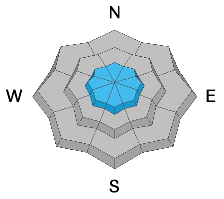
The best riding and turning conditions are on the northerly facing slopes above about 8,000' in elevation, where you can still find dry cold powder snow. Yesterday's warm temperatures from green housing, shrink wrapped the mountain snowpack and made most all other aspects and elevations damp and soggy by mid morning. Today, you can expect all but mid and upper elevation northerly facing terrain to be crusted with 2-4" of dense surfy snow on top.
Recent Avalanches
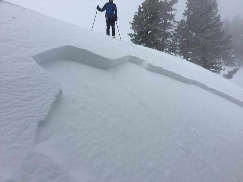
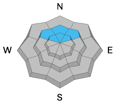
Yesterday, Drew Hardesty and Zinnia Wilson were in the Cutler Ridge area of Ben Lomond where they had multiple collapses within the snowpack as well as propagation in their snowpit tests. They found a thin layer of near surface faceted snow as well as surface hoar that was buried on March 20th. The collapsing and the layer was only discovered on mid and upper elevation northwest, north and northeast facing slopes. It's worth reading their observation HERE.
It was just two days ago when pro observer Bill Brandt was finding very sensitive soft slabs on test slopes from 7,200' to 8,100'. These soft slabs were releasing on near surface facets and surface hoar at the mid elevations, and were 40 to 100' wide. (pic below)
Ad
Avalanche Problem #1
Wind Drifted Snow
Type
Location
Likelihood
Size
Description
The southerly winds picked up last night around 7:00 pm and have continued to blow at speeds of 15-20 mph gusting into the 20's and 30's at the upper elevations. With new snow to move around I am expecting there to be drifts of wind blown snow and shallow sensitive soft slabs scattered around the high elevations.
Keep and eye out and watch for areas that look fat, pillowy, smooth and rounded as they should be avoided. In forgiving terrain (clean run outs) one should be able to tease these drifts with slope cuts. However, in terrain with high consequence (trees, rocks, cliffs, sustained steepness) it's best to ride around these drifts or enter the slope in places that have not been effected by the wind.
The problem could be more complicated on the mid and upper elevation northwest, north and northeast facing slopes where the wind is loading snow onto a buried weak layer (see below). Avalanches 1-2' feet deep and up to 200' feet wide could be possible.
Avalanche Problem #2
Persistent Weak Layer
Type
Location
Likelihood
Size
Description
The weather between March 17th through the 20th in the Ogden area was sunny skies, followed by clear and cold nights each day. This lead to a faceting event that was buried on March 20th. As with the avalanches Bill Brandt triggered on the 22nd along with the many collapses reported yesterday one should take caution today. Anytime, we hear reports of collapsing a huge red flag goes off in my head. My strategy for today would be avoidance and I would let the new snow adjust and settle for another day or two.
The good news: is this problem is isolated to sheltered northwest, north and northeast facing terrain above about 7,500' in elevation. The bad news: this is the terrain that will have the best riding conditions today. Before committing to any steep slope, take your shovel out and dig roughly 18" down and identify if this layer is present or not. Or keep your slope angles down (less than 30°) for the next couple days as we figure out what this layer is up to.
Avalanche Problem #3
Wet Snow
Type
Location
Likelihood
Size
Description
Overnight temperatures remained warm in the Ogden area mountains and elevations below 8,000' did not drop below freezing. For today, I would expect the snow at the Mid and Lower elevations to remain damp and soggy. The more new snow and steeper the terrain where you are, the bigger these wet loose avalanches will be. They will likely run on the old melt freeze ice crusts, they may go much further than expected. If the snow is damp, head to lower angle slopes and avoid travel in and below run out zones, like gullies.
General Announcements
This information does not apply to developed ski areas or highways where avalanche control is normally done. This forecast is from the U.S.D.A. Forest Service, which is solely responsible for its content. This forecast describes general avalanche conditions and local variations always occur.