Forecast for the Ogden Area Mountains

Drew Hardesty
Issued by Drew Hardesty for
Saturday, March 19, 2022
A MODERATE danger exists on steep northwest to north to east facing aspects of all elevations. You can trigger 1-3' deep avalanches and you can trigger from a distance or from below. Collapsing and cracking may not be noted. Pay attention to heating and cloud cover to determine the wet avalanche potential and look for the development of wind drifts by the afternoon.
Low
Moderate
Considerable
High
Extreme
Learn how to read the forecast here
Special Announcements
Please help support avalanche forecasting throughout Utah. Donate to the Spring Campaign to help raise the funds to support the forecasting you rely on.
Weather and Snow
Skies are partly cloudy. Winds are light but they've begun to back to the west ahead of tomorrow's storm. Temperatures are in the upper-20s to low 30s.
Travel is easy with excellent coverage, particularly in the upper elevations. Base depths are 50-60" in the upper elevations with wind and sun crusts in exposed locations.

For today, expect the winds of change. Winds will continue backing to the southwest and I expect to see wind speeds of 30-40mph with gusts to 60 by late afternoon. Temperatures will rise into the mid-30s up high, the mid-40s down low. Mid and upper level clouds will begin to stream in throughout the day. Tomorrow's cold front crashes through mid-morning and while the storm looks like it is splitting apart, we may still pick up 2-5" by Sunday afternoon. We'll see.
Recent Avalanches
None.
Find all the observations HERE.

Greg Gagne's Week in Review is published and can be found HERE.
Ad
Avalanche Problem #1
Persistent Weak Layer
Type
Location
Likelihood
Size
Description
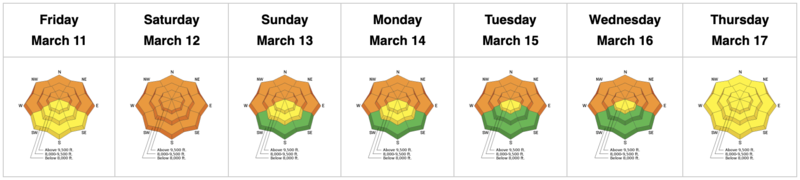
Even though it has been over a week since the last reported significant avalanche in the Ogden area mountains; I would continue to exercise caution wherever the buried facets exist under a slab of more cohesive snow.
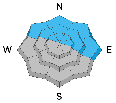
Human triggered avalanches 1-3' deep remain possible on steep northwest to north to east facing slopes of all elevations. You will probably trigger them from a distance.
We estimate the danger by looking at the likelihood, size, spatial distribution, and character, if you will, of the avalanche. For all intents and purposes, the size and locations haven't changed. What has changed is that these avalanches are more stubborn and less sensitive and - lacking immediate signs of instability (ie-cracking/collapsing) - will want to lure you out onto the steep terrain. Don't fall for it.

*Uncertainty. High uncertainty requires a wide margin for error.
  • Know that you don't know. You won't know exactly when and where you will trigger the avalanche, but you will probably trigger it from a distance. These types of avalanches are Unmanageable.
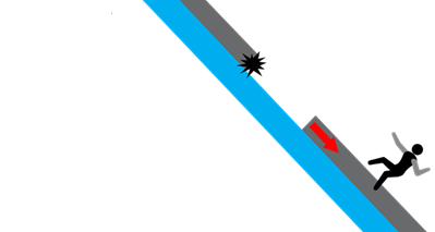
  • If you choose to ride suspect terrain, choose terrain that won't kill you if the snowpack disagrees with your assessment of it. Bashed through the trees, over a cliff and buried deeply in a gulley? No good.
  • Be cognizant of runout zones. How far will the avalanche run if you trigger it from below? Do you know how to estimate runouts?
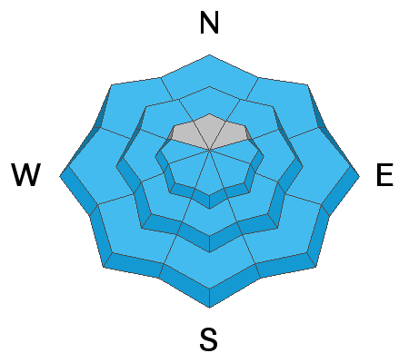
TRAVEL ADVICE - CHOOSE LOWER ANGLE SLOPES WITH NO OVERHEAD HAZARD.
Avalanche Problem #2
Wet Snow
Type
Location
Likelihood
Size
Description
The wet avalanche conditions will depend on the cloud cover and winds. IF there is enough sun, watch for the solar aspects to become wet and unstable with daytime heating. IF the clouds result in greenhousing, the low/mid elevation polar aspects may produce some wet activity as well.

Signs that wet avalanches will start happening include; seeing other small wet slides, seeing snowballs or pinwheels roll downhill with increasing frequency, and seeing upper layers of snow become increasingly wet.
Avalanche Problem #3
Wind Drifted Snow
Type
Location
Likelihood
Size
Description
By afternoon, the winds will be strong from the southwest. Watch for snow transport and fresh, potentially sensitive drifts in steep terrain. Wind drifts are more likely to be found on steep northwest to north to east facing aspects at the mid and upper elevations.
General Announcements
Who's up for some free avalanche training? Get a refresher, become better prepared for an upcoming avalanche class, or just boost your skills. Go to https://learn.kbyg.org/ and scroll down to Step 2 for a series of interactive online avalanche courses produced by the UAC.
This information does not apply to developed ski areas or highways where avalanche control is normally done. This forecast is from the U.S.D.A. Forest Service, which is solely responsible for its content. This forecast describes general avalanche conditions and local variations always occur.