UDOT PLANNED AVALANCHE CLOSURES!!

Forecast for the Ogden Area Mountains

Nikki Champion
Issued by Nikki Champion on
Thursday morning, March 14, 2024
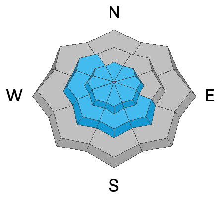
Overall, the avalanche danger is MODERATE at all upper and mid-elevation slopes where periods of heavy snowfall and elevated winds have created heightened avalanche conditions today.
Throughout the day the increasing winds will continue to form unstable slabs of wind-drifted snow. Both loose snow and slab avalanches may be possible within the different layers of new snow from the past few days.
The avalanche danger is LOW at low elevations.

Easterly winds are unusual for the Wasatch, and with unusual weather patterns come unusual loading patterns. Pay attention to rising and changing conditions throughout the day.
Low
Moderate
Considerable
High
Extreme
Learn how to read the forecast here
Special Announcements
Support the UAC website rebuild by donating to our Spring Campaign. Save lives by making a donation today!
Weather and Snow
A strong cold front moved its way through northern Utah over the last 48 hours, bringing heavy snowfall throughout the day yesterday and an additional trace to 1 inch of snow overnight. Storm totals are between 6-10 inches of snow. Temperatures are in the upper teens to low 20s °F, and winds have begun to transition to east-northeasterly, gusting to 30 mph at mid-elevations and near 40 at upper elevations.
Today, the low-pressure system will continue to track south, bringing most of the associated precipitation with it as an easterly flow sets over the area. This will result in mostly cloudy skies, with a chance for light snow throughout the day but no significant precipitation. The easterly winds will continue to increase, with peak wind speeds expected late morning into early afternoon. Expect gusts up to 30 mph along exposed ridges and peaks at the mid elevations, and gusts up to 50 mph at upper elevations. Temperatures will climb into the mid to upper-30s °F.

With all of the fresh snow, travel and riding conditions should be excellent today - But seize the opportunity while you can, as winds have shifted more easterly and will continue to increase later this morning and into the weekend; easterly winds are notorious for wreaking havoc on the Wasatch.
Recent Avalanches
No new avalanches were reported from the Ogden area mountains. Drew reported sluffing on the steepest slopes of Davenport Creek, and ski patrol reported numerous wind slabs at upper elevations to up to D1.5, these wind slabs weren't very sensitive to skis but more sensitive to explosives.
In the Central Wasatch, there were Widespread sensitive soft slabs of both new snow and wind-drifted snow were observed in the backcountry yesterday, including some smaller catch-and-carry occurrences in places like El Rollo. See photos below. Most of these avalanches were D1-1.5 in size, ranging between 15-50 feet wide and running 15-100 feet long. On the solar aspects, most of these avalanches failed 10-18 inches deep on the firm new snow, old snow interface. Outside of the solar aspects, some of these avalanches failed shallower in the snowpack within a density change within the snow, the wind-drifted snow, or on top of the new snow old snow interface. In slightly steeper terrain, there were long-running sluffs that entrained a lot of snow.
There were reports of signs indicating a natural cycle that occurred both the prior night and during periods of higher PI throughout the day.
Ad
Avalanche Problem #1
Wind Drifted Snow
Type
Location
Likelihood
Size
Description
The bump in overnight easterly winds, plus soft snow available for transport, will continue to form soft slabs of wind-drifted snow up to 1-2 feet deep. With the winds slated to continue rising throughout the day, these slabs will only grow and become more cohesive. They will be most pronounced on lee-ward-facing slopes, but such high winds can load any aspect because winds swirl and change direction as they pass through the mountains.
With the recent new snow, slopes with any signs of wind-drifted snow, such as texture and pillow-shaped features, may be more challenging to identify. For that reason, I would approach steep terrain features that could allow drifting snow to accumulate as if triggering a fresh soft slab is possible.

Easterly wind patterns are unusual for Northern Utah and have a habit of causing issues both by impacting our riding conditions and by creating generally tricky avalanche conditions. Last year, during a more easterly weather pattern, forecaster Drew Hardesty said, "Nothing good comes from an east wind." Heads up and pay attention to changing conditions while traveling in the backcountry today.
CORNICES are not to be messed with. Limit your exposure to ridgelines near cornices and slopes below cornices. A cornice fall could trigger a larger slab of wind-drifted snow below.
Avalanche Problem #2
New Snow
Type
Location
Likelihood
Size
Description
Across the range, the new snow has a variety of excellent bed surfaces and new snow/old snow interfaces to slide on from the last weekend. And while instabilities within the storm snow should begin to settle out today, out of the wind zone, you can still expect to find sensitive soft slabs of new snow and fast, long-running sluffs on all aspects.
Any type of avalanche today could entrain a lot more snow than expected; watch for terrain traps where a smaller avalanche could bury a person.
General Announcements
This information does not apply to developed ski areas or highways where avalanche control is normally done. This forecast is from the U.S.D.A. Forest Service, which is solely responsible for its content. This forecast describes general avalanche conditions and local variations always occur.