Forecast for the Ogden Area Mountains

Dave Kelly
Issued by Dave Kelly for
Saturday, March 11, 2023
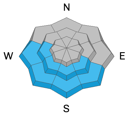
There is a CONSIDERABLE avalanche hazard in mid and upper elevation terrain for wind-drifted snow avalanches that may be 1-3' deep and up to 200' wide. There is a CONSIDERABLE avalanche hazard in mid and lower elevation southerly facing terrain for wet snow avalanches and a MODERATE avalanche hazard on low elevation north facing terrain.

Yesterday's winds created stiff slabs of wind-drifted snow on the leeward side of ridgelines and cross-loaded slopes at mid and upper elevations. Avoid smooth rounded deposits of new snow, and stay off of steep slopes if you experience any cracking or collapsing. Any solar warmed slope has the potential to release wet loose avalanches.
Low
Moderate
Considerable
High
Extreme
Learn how to read the forecast here
Special Announcements
The UAC is sad to report that two skiers were caught and buried in a large avalanche in Upper Weber Canyon on Thursday March 9 in the Uinta's. One skier was successfully rescued and survived. Sadly, the other skier was buried deeper and did not survive. A preliminary report is available HERE.

Please consider donating to the spring campaign to help our team implement innovative tools and better provide you with the information you rely on.
Weather and Snow
Under clear skies trailhead temperatures are in the mid-20's ˚F while the highest ridgeline temperatures are in the mid-teens ˚F. Winds are blowing from the west in the teens gusting to the 20's at the 9,000' ridgelines and blowing from the southwest in the single digits gusting to the teen's MPH at the 8,000' ridgelines. Overnight there was a period of thunder and lightning with the frontal passage and in the last twelve hours mountain locations received 1-3" of high-density snow with rain up to 8,000' feet.

Today, winds will blow from the west-southwest 15 to 25 MPH at the 8,000' ridgelines and 30 gusting to 45 MPH at the 9,000' ridgelines. Temperatures will be 31-35 ˚F. Skies will be clear this morning with increasing clouds this afternoon and a chance of up to 1" of snow. The freezing level will rise from 4,000'-5,000' during the day.

Storm Totals
  • Ogden Area Mountains 4-6" snow (.80-1" water)
Recent Avalanches
Yesterday we had reports of strong winds in the Ogden Area Mountains which limited the avalanche observations we received. Get all observations HERE.
Ad
Avalanche Problem #1
Wind Drifted Snow
Type
Location
Likelihood
Size
Description
Yesterday, there were reports of hollow wind-drifts on top of lower density snow in terrain above tree line. These drifts may now be covered over by 3-6" of new snow. Look for signs of wind-drifting such as snowdrifts, smooth and rounded pillows of snow, and shooting cracks or whoomphing. Avoid these slopes.
Cornices are currently large and growing. Give cornices, and the edges of cornices a wide berth as they often break farther back than expected. Limit your exposure to slopes below cornices.
Avalanche Problem #2
Wet Snow
Type
Location
Likelihood
Size
Description
Any steep slope or rocky cliff band will shed new snow with the first hint of warm March sun. Yesterday there were reports of rain to 8,000' which may lead to a mushy layer of wet snow underneath last night's higher density snow that could avalanche on steep terrain. These wet loose avalanches that may step down and trigger wet slab avalanches in isolated gully features particularly if there are sun-warmed rocks nearby.
Avalanche Problem #3
New Snow
Type
Location
Likelihood
Size
Description
Today both slab and loose snow avalanches may break 1-3' deep within layers of new snow from yesterdays' storm, and the last two weeks of new snow.

We have had a lot of snow over the last few weeks and there are areas where we are finding decomposing stellar crystals, buried ice crusts, rime crusts, and isolated areas of faceted snow buried 1-3' from the surface and it's a good reminder that strange weather (like above average snowfall) leads to strange avalanches. The solar aspects, particularly southeasterly facing slopes are acting more like a northerly aspect. Typically, spring is the time to send bigger objectives. With all the snow this season it's not quite sending time yet. Give it time and if things keep up, we'll be skiing big lines into June.
Additional Information
While not directly avalanche problems, tree wells, "snow immersion suffocation" is a backcountry danger worth noting. Read more HERE.
With so much snow on rooftops in mountain communities, roof avalanches will be a significant hazard as the sun warms roofs in mountain neighborhoods. Children playing and adults shoveling solo are especially vulnerable to this hazard.
General Announcements
This information does not apply to developed ski areas or highways where avalanche control is normally done. This forecast is from the U.S.D.A. Forest Service, which is solely responsible for its content. This forecast describes general avalanche conditions and local variations always occur.