Forecast for the Ogden Area Mountains

Nikki Champion
Issued by Nikki Champion for
Friday, March 11, 2022
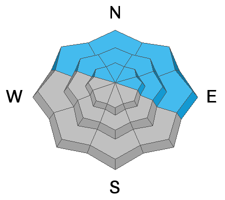
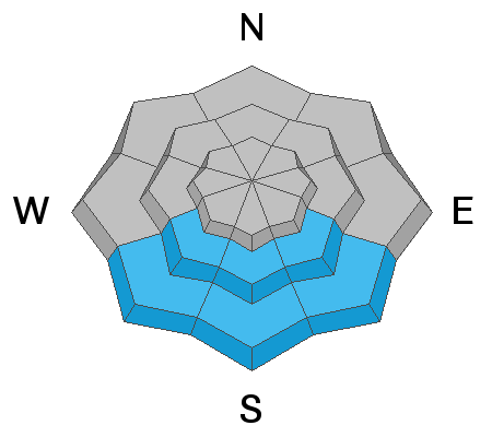
There is CONSIDERABLE avalanche danger on steep northwest-to north to east-facing aspects. You are likely to trigger an avalanche 1-3' deep failing on a buried persistent weak layer faceted snow. Conservative decision-making will be essential today.
There is a MODERATE danger on steep slopes facing west to the south to southeast. This primarily involves soft slab avalanches failing within fresh drifts of wind-blown snow. The cooler temperatures and elevated winds should help keep the snow from heating up too much, but some wet loose avalanches could begin to happen on the southern end of the compass at lower and mid-elevations.
Low
Moderate
Considerable
High
Extreme
Learn how to read the forecast here
Special Avalanche Bulletin
Unusually late winter avalanche conditions exist and avalanche danger remains elevated.
Deep, dangerous, and potentially deadly slides breaking several feet deep and hundreds of feet wide can be triggered from a distance and low on the slope.
Avoid being on, near, or below all steep slopes on the northern end of the compass.
Weather and Snow
This morning, the skies are clear. Mountain temperatures range in the single digits and low teens. Winds increased again overnight now blowing from the northwest at speeds of 10-20 mph, gusting into the upper 20s across mid-elevations and gusting near 40 mph across upper elevation ridgelines. A few areas reported a final dusting of snowfall through the morning before high pressure began to build after that impressive and much-needed storm.
Final Storm Totals
Ogden Area Mountains: 17-20" (1.35-1.73 H2O)
Today, we should see sunny skies and warming temperatures. Mountain temperatures will top out in the upper 20s and low 30s °F. Winds will remain from the northwest and blow 10-20 mph with gusts into the mid-'30s at mid-elevations.
The next system is expected to move through the area beginning Sunday. However, this will be a much more fast-moving system in nature, which means it could lack mositure.
Recent Avalanches
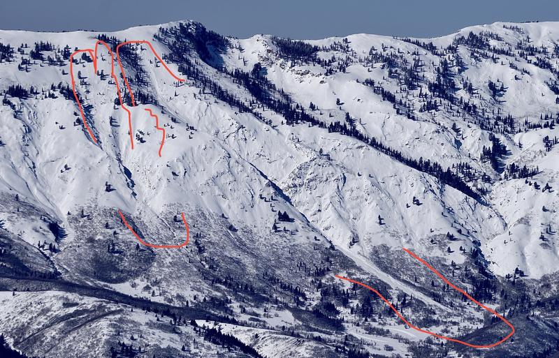
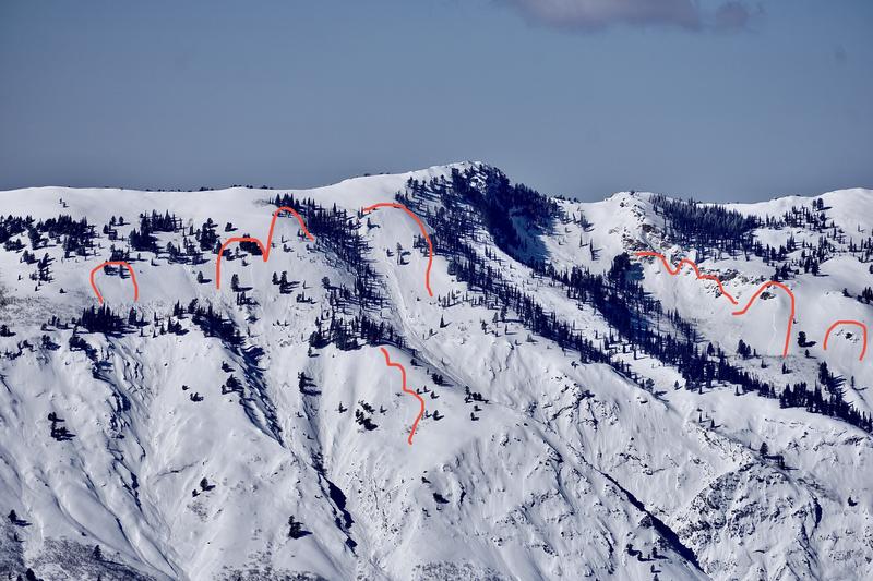
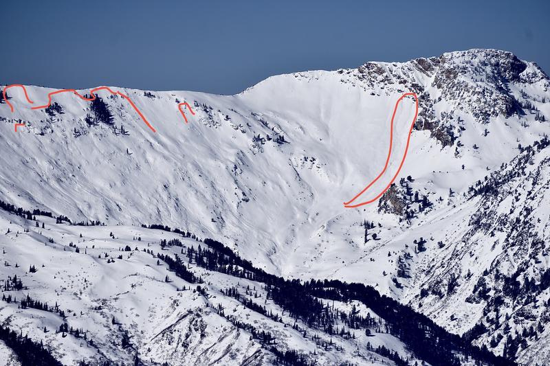
In the past 24hrs, no new avalanches were reported in the Ogden backcountry, but we did receive updated photos from avalanches that occurred naturally on the 9th.
Photos below show a widespread natural avalanche cycle that occurred on the east side of Chilly Peak, the Chilly Peak slabs, and Zero G Chute. (D. Wewer)
Photos below show natural avalanche cycle from Culter Basin (D. Wewer)
Find all of the updated observations and avalanches HERE.
Ad
Avalanche Problem #1
Persistent Weak Layer
Type
Location
Likelihood
Size
Description
Dangerous avalanche conditions exist on all slopes facing Northwest through North through East where 1-3' of new storm snow, and wind-blown snow has overloaded the weak, faceted snow from January and February. Our PWL locator rose continues to expand, as we have now seen multiple human triggered and natural avalanches occurring on facets within those lower elevation bands (below 7000').
We have already begun seeing widespread avalanche activity within this layer, with every bump of wind and new snowfall event these avalanches are only becoming larger, more destructive, and more deadly. Avalanches may break down 1-3' deep, possibly deeper, and propagate up to 100' wide. Either way, these avalanches are likely to be unsurvivable.
A few words of caution:
  • Signs of instability may not always be present: you may or may not see or experience shooting cracks or audible whumping.
  • Tracks on the slope offer zero signs of stability. Avalanches will take out multiple existing tracks.
  • You can trigger these avalanches from a distance or below.
  • Still continue to look for signs of new snow instabilities such as cracking, and collapsing. Triggering an avalanche that initially fails in any lingering storm snow or stubborn wind drifted snow could easily step down more deeply into the weak faceted snow.
Bottom Line: There is no outsmarting this problem - avoidance is the answer. If you're traveling on the shady side of the compass, be sure to stick to terrain that's under 30° degrees in slope steepness with nothing steep above or adjacent to you.
Avalanche Problem #2
Wind Drifted Snow
Type
Location
Likelihood
Size
Description
Winds picked up again overnight, currently gusting near 40 mph. With so much new snow available for transport, even a small bump in winds will begin drifting snow. Sustained high winds can deposit snow around terrain features on almost any aspect, called cross-loading. For this reason, I would expect to find slabs of wind drifted snow at all upper and mid-elevation slopes, especially along with terrain features such as ridgelines, sub ridges, and gullies.
These wind drifts will be particularly touchy at upper elevation aspects facing west through north through east, where the wind drifted snow will be sitting on top of the weak faceted snow. Any wind drifted snow or new snow avalanche triggered can step down into deeper weaker layers creating a much larger avalanche.
Today look for slopes with any signs of wind drifted snow, such as cracking, hollow noises, and pillow-shaped snow, and avoiding those slopes.
Avalanche Problem #3
Wet Snow
Type
Location
Likelihood
Size
Description
Winds today should help keep the snow from heating up too much, but with clear skies, and direct sunlight it wouldn't take much for the new snow to warm quickly, become wet, and begin producing wet loose avalanches.
The balance between sunshine, air temperatures, radiation, and wind all determine how warm and wet the snow becomes, and it is hard to know exactly how all those meteorological inputs will add up. The main point is to always expect some wet loose avalanches as the day heats up and to look for clues of a rising danger. Signs that wet avalanches will start happening include; seeing other small wet slides, seeing snowballs or pinwheels roll downhill with increasing frequency, and seeing upper layers of snow become increasingly wet.
Additional Information
Since it's so dangerous and the roads and traffic will be a mess. Please take a minute and check out Drew Hardesty's new blog on "Our Jan/Feb Drought Layer and PWL Summary of Avalanche Activity on This Layering for the Central Wasatch Range." HERE.
General Announcements
Who's up for some free avalanche training? Get a refresher, become better prepared for an upcoming avalanche class, or just boost your skills. Go to https://learn.kbyg.org/ and scroll down to Step 2 for a series of interactive online avalanche courses produced by the UAC.
This information does not apply to developed ski areas or highways where avalanche control is normally done. This forecast is from the U.S.D.A. Forest Service, which is solely responsible for its content. This forecast describes general avalanche conditions and local variations always occur.