Forecast for the Ogden Area Mountains

Mark Staples
Issued by Mark Staples for
Tuesday, February 6, 2024
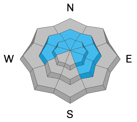
Today the avalanche danger is CONSIDERABLE above 8500 feet. Heavy snowfall and strong south winds since yesterday will make human triggered avalanches likely on any wind loaded slope.
At mid and low elevations, the avalanche danger is MODERATE. Watch for any slope with wind drifted snow, but also the new snow could make some soft slab avalanches.
Low
Moderate
Considerable
High
Extreme
Learn how to read the forecast here
Weather and Snow
Since yesterday morning, snowfall amounts in the Ogden area mountains are 8-12 inches of dense snow containing 1-1.4 inches of water. Winds from the south were blowing 30-44 mph gusting to 55 mph above 9000 ft last night. They were gusting to 25 mph at lower elevations.
This morning temperatures are hovering just under freezing in most areas and in the mid 20s F at upper elevation ridgelines. Winds eased a little and are blowing about 20 mph gusting to 30 mph from the south.
Today, winds should increase and blow 30 mph from the south. Temperatures will rise into the low to mid 30s F but some cooler air will move overhead and keep upper elevation temps in the mid 20s F. This afternoon a trace to an inch of snow should fall with another few inches tonight. The NWS has issued a Winter Weather Advisory for the Wasatch Mountains north of I-80 with 5-10 inches of snow expected by Thursday morning. Scroll to the bottom to see a map of expected snowfall.
Recent Avalanches
One ski patrol yesterday reported a surprising avalanche intentionally triggered that was 3 feet deep and 300 feet wide failing on a density change above a melt freeze crust on an ENE facing slope at 8900 ft. When ski patrollers who work in the same terrain every day get surprised, we should take note before heading into backcountry terrain.
Ad
Avalanche Problem #1
Wind Drifted Snow
Type
Location
Likelihood
Size
Description
Dense slabs of wind drifted snow are the main concern especially as winds from the south are expected to increase again today. It's a game of tug-of-war: these wind slabs are trying to stabilize and bond, but loading from continued strong winds will keep them on edge. I've been fooled many times by unreactive wind slabs on test slopes only to find other wind slabs that I have triggered.
I'd avoid any wind loaded slope today and give these dense slabs of wind drifted snow time to bond.
Avalanche Problem #2
New Snow
Type
Location
Likelihood
Size
Description
I suspect the warm dense snow is well bonded and avoiding any wind loaded slopes will be the key to avoiding avalanches. However, it's worth assessing the new snow. With up to 1.4 inches of water in the new snow, it could make a meaty soft slab avalanche. Check small, steep, test slopes; step or ride above the track from another person; and do a few snowpack tests to see how the new snow has bonded to itself and underlying layers. Look for a melt freeze crust maybe 2-3 feet deep that formed during recent warm, sunny weather and assess how the snow is bonding to that crust.
Avalanche Problem #3
Persistent Weak Layer
Type
Location
Likelihood
Size
Description
There haven't been any slab avalanches failing on a persistent weak layer in the Ogden area mountains but they continue to pop up further south (like this one or this one), mostly on steep, rocky slopes with a thinner snowpack. I bet you could find similar spots mostly in upper elevation areas. With dense, heavy new snow today containing over an inch of water, it will add a decent amount of stress to any deeply buried faceted layers. Not enough stress to cause widespread problems, but certainly enough to causes a few surprises.
Additional Information
General Announcements
This information does not apply to developed ski areas or highways where avalanche control is normally done. This forecast is from the U.S.D.A. Forest Service, which is solely responsible for its content. This forecast describes general avalanche conditions and local variations always occur.