Forecast for the Ogden Area Mountains

Greg Gagne
Issued by Greg Gagne for
Monday, February 5, 2024
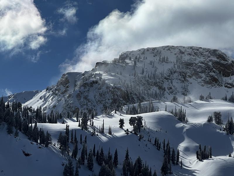
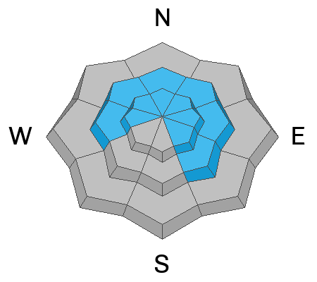
The avalanche danger is CONSIDERABLE at the upper-elevation and MODERATE at the mid-elevations where triggering slabs of wind-drifted or storm snow are likely. Watch for cracking as a sign of instability. Avalanches may run fast and far on slick crusts underneath.
There is also a possibility of triggering a large and dangerous avalanche, particularly on steep mid and upper-elevation slopes facing west through north and southeast, due to a buried persistent weak layer. If one of these avalanches is triggered, it will break 3-5 feet deep and well over a hundred feet wide.
There is a LOW danger at low elevations.
Low
Moderate
Considerable
High
Extreme
Learn how to read the forecast here
Weather and Snow
This morning, Temperatures are in the mid to upper 20's F with strong winds from the south, gusting into the 40's mph along exposed, upper elevation ridgelines. With stronger gusts in the 50's and 60's mph along the Ogden Skyline. Up to an inch or two of new snow has shown up on some automated weather stations, but I'm suspicious some of that may be attributed to blowing snow.
For today, temperatures will rise into the 30's and winds from the south will remain strong, gusting into the 40's and 50' mph along exposed ridges, with 3-5" of new snow by late afternoon.
A stormy week is ahead with a brief break overnight into Tuesday, followed by more winds and snow for much of the upcoming week.
Recent Avalanches
No backcountry avalanches were reported from the Ogden mountains on Sunday, but to our south in the Salt Lake mountains, two avalanches failing in the persistent weak layer (PWL) were reported in Hidden Canyon in the Brighton backcountry and in Days Fork.
Ad
Avalanche Problem #1
Wind Drifted Snow
Type
Location
Likelihood
Size
Description
Winds from the south began to increase Sunday afternoon and have grown stronger overnight. Expect sensitive wind slabs at the mid and upper elevations, and although these will likely be found on the lee aspects facing north and east, strong winds can work around terrain features and cross-load onto slopes on all aspects. Fresh slabs of wind-drifted snow may run fast and far as they will be on top of slick crusts that formed on all aspects last week. The photo below is from my field day Sunday around Ben Lomond and Mount Willard showing wind-drifting along exposed ridgelines.
Avalanche Problem #2
Persistent Weak Layer
Type
Location
Likelihood
Size
Description
Two avalanches failing in the PWL in the Salt Lake mountains on Sunday continue to remind us the PWL remains a concern. The avalanches in the Salt Lake mountains have been triggered in thinner snowpack areas (thinner - perhaps - because they avalanched in January) and propagating to portions of the slope where the slab is 3-5' deep. Although we haven't seen the activity in the PWL from the Salt Lake mountains here in the Ogden mountains, I believe there are isolated areas where an avalanche failing in the PWL exist, especially in steep, thin, rocky terrain.

Overall, the likelihood or possibility of triggering an avalanche on this layer has decreased over the past few weeks, but the consequences of triggering an avalanche on this layer remain the same. With the upcoming storm bringing additional snow and water weight and strong southerly winds, the likelihood of triggering an avalanche on this layer will begin rising today through this week.
General Announcements
This information does not apply to developed ski areas or highways where avalanche control is normally done. This forecast is from the U.S.D.A. Forest Service, which is solely responsible for its content. This forecast describes general avalanche conditions and local variations always occur.