UDOT PLANNED AVALANCHE CLOSURES!!

Forecast for the Ogden Area Mountains

Evelyn Lees
Issued by Evelyn Lees for
Saturday, December 8, 2018
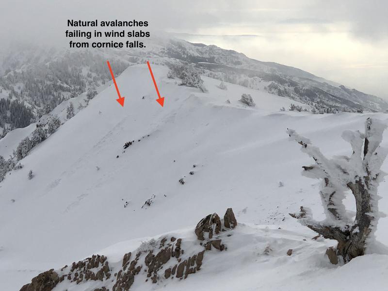
The Ogden area mountains have a mostly LOW avalanche danger, but a low danger does not mean no danger. The cornices along the high ridge lines are very large, and could break beneath the weight of a person. Avoid any new small wind drifts that form as the southwesterly winds increase. While pockets of faceted snow exist near the ground on steep, upper elevations slopes, none have produced avalanches in the Ogden area mountains yet. Still, if you travel in steep terrain, only expose one person at a time, especially on steep, shady slopes.
Low
Moderate
Considerable
High
Extreme
Learn how to read the forecast here
Weather and Snow
Mountain temperatures are in the 20s this morning, and southwesterly winds very light, averaging 5 to 10 mph, with Mount Ogden averaging 15 mph, gusting to 20. Skies will remain mostly cloudy for the day, with a dusting of fresh snow possible as a weak disturbance moves by to the north. Winds across the highest ridge lines will increase, averaging around 25 mph. The high pressure ridge moves in on Sunday, and by Monday, 9000’ temperatures will warm to near 40. The next chance for a shot of snow is around Wednesday.
Snow depths in the Ogden area mountains average 2 to 3 feet, with as much as 4 feet at the upper elevations. Though the sunny slopes are sun crusted, decent dense powder remains on the shady slopes.
Recent Avalanches
Recent wind drifts that were active Wednesday have settled out. But cornices are unusually large for this time of year, and yesterday Greg Gagne and Doug Wewer saw evidence of natural avalanches on leeward easterly aspects from recent westerly winds. These were from natural cornice falls which triggered small, fresh wind slabs. Check out their full observation.
Ad
Avalanche Problem #1
Normal Caution
Type
Location
Likelihood
Size
Description
Cornices in the Ogden area mountains are unusually large for this time of year, and could surprise you by breaking back further than expected. Stay way back from the edge, and avoid travel beneath them. Also avoid any other new wind drifts that may form as the southwesterly winds increase slightly today.
Otherwise, the Ogden mountains may have some of the strongest, most stable snow across the state because had almost no snow on the ground prior to Thanksgiving. There are a few upper elevation, shady slopes that have a little bit of this old snow. It is a very thin layer, but could produce an avalanche. Fortunately this layer has not produced avalanches in the Ogden area. Just in case, make sure to only expose one person at a time to avalanche terrain and to watch them from a safe location. Doug and Greg found a thin layer of facets yesterday in one spot - see the video below.
General Announcements
This information does not apply to developed ski areas or highways where avalanche control is normally done. This forecast is from the U.S.D.A. Forest Service, which is solely responsible for its content. This forecast describes general avalanche conditions and local variations always occur.