Forecast for the Ogden Area Mountains

Trent Meisenheimer
Issued by Trent Meisenheimer for
Sunday, December 31, 2023
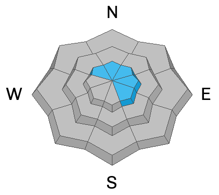
The avalanche danger is MODERATE on steep slopes that face northwest, north, northeast, east, and southeast for shallow soft or hard slabs of wind-drifted snow. Human-triggered avalanches are possible.
You will find a LOW avalanche danger out of the wind-effected snow where human-triggered avalanches are unlikely.
Low
Moderate
Considerable
High
Extreme
Learn how to read the forecast here
Special Announcements
To fulfill our mission, the UAC relies on our amazing backcountry community. Your support helps pay for the daily avalanche forecast, free awareness presentations across the state, and new tools like the new Avalanche and Observation Explorer. As the end of the year approaches, please consider donating to the UAC.
Weather and Snow
Under clear skies, the mountain temperatures range from 29-32 °F. Winds have finally relaxed across the range and blow from the west and southwest at 5-10 mph with the occasional gust to 20.
We will have plenty of sunshine today with temperatures warming up into the mid to upper 30s °F. Winds from the southwest will be calm for the day, only blowing 5-15 mph across most upper-elevation terrain. The riding and turning conditions are still good, with soft recycled powder on sheltered slopes. The sunny aspect will be crusted this morning but will soften with daytime heating.
Recent Avalanches
No new avalanches were reported in the Ogden area. We did get one observation from Willard Peak.
Yesterday in the Wasatch Range, a skier in Cardiff Fork on Powerline ended up getting caught in their sluff. They said it was surprising and caught them off guard. The sluff was roughly 2 feet deep and ran 100 feet downhill.
On Argenta in Big Cottonwood Canyon, a reported natural avalanche ran for 30-40 seconds off the cliffs on the NW side at 10,100' (picture below).
Ad
Avalanche Problem #1
Wind Drifted Snow
Type
Location
Likelihood
Size
Description
In the past 36 hours winds from the southwest picked up and blew 15-30 mph across the upper elevations. This morning the winds have relaxed. However, it's hard to ignore these winds, as I would imagine they were able to move some snow across the exposed terrain. Therefore, I would be on the lookout for fresh, soft or hard slabs of wind-drifted snow. These slabs will likely be less than a foot deep, but they could be sensitive to the weight of riders as our snow surface is plagued with weak faceted snow.
If you find yourself on firm, hard snow or snow that is stiff, punchy, or upside down, you've likely found a wind slab, and it's possible it could avalanche. Remember, shooting cracks or whumpfs (collapsing) are signs of unstable snow.
My advice would be to avoid the slopes affected by the wind and stay in the soft, re-crystalized snow that offers up nice riding and turning conditions. On these slopes, you will find a LOW avalanche danger where you only need to worry about your sluff (dry loose avalanche).
General Announcements
This information does not apply to developed ski areas or highways where avalanche control is normally done. This forecast is from the U.S.D.A. Forest Service, which is solely responsible for its content. This forecast describes general avalanche conditions and local variations always occur.