Forecast for the Ogden Area Mountains

Trent Meisenheimer
Issued by Trent Meisenheimer for
Saturday, December 3, 2022
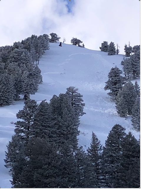
Today we have a CONSIDERABLE avalanche danger on all mid and upper-elevation steep slopes where avalanches can break 1-3' deep and hundreds of feet wide, failing on a persistent weak layer of faceted snow.
Today is NOT the day to mess with steep avalanche-prone terrain. Meaning any slope steeper than 30° degrees in slope steepness. Avalanches can be triggered remotely (from a distance) and travel long distances into the flats.

Great riding conditions will be found in low-angled, wind-sheltered terrain with nothing steep above or adjacent to you.
Low
Moderate
Considerable
High
Extreme
Learn how to read the forecast here
Special Announcements
Join the Utah Avalanche Center and the Utah Division of Outdoor Recreation to celebrate the Fourth Annual Avalanche Awareness week from December 4 - December 11. Click HERE to view the full list of events for the week.
Weather and Snow
Current mountain temperatures are 15-25 °F across most upper-elevation stations. Overnight the winds backed to the southwest and increased in speeds, and are currently blowing 10-15 mph with gusts into the low 20's. Some upper elevation stations read higher wind speeds blowing 15-25 mph.
Today as the southerly winds build, it will usher in warmer temperatures climbing into the 25-30 degree Fahrenheit range. Southwest winds will blow 10-20 mph with gusts reaching into the mid 20's across most of the upper elevation terrain. Clouds will quickly build, and if we are lucky enough, we will see a trace to a couple of inches of new snow later today into tonight.
Over the past few days, relentless south and west winds have truly changed the landscape, with some slopes stripped to the dirt and others having drifts of wind-blown snow 1-3' deep (or deeper). Thursday's 6-12" storm snow was a welcome site and generally helped the riding conditions.
Recent Avalanches
Snow safety teams triggered many avalanches with explosives that were large enough to catch, carry, bury, and or kill a person. There were three observations submitted from the Ogden area yesterday, and be sure to check them out HERE.
Photo: Explosive work, Ogden Mountains.
Ad
Avalanche Problem #1
Persistent Weak Layer
Type
Location
Likelihood
Size
Description
We had roughly 16 days of clear and cold weather in November, where our snowpack became weaker each day/night, creating a layer of weak faceted snow called a Persistent Weak Layer. This weak layer was buried on the 27th of November on almost all aspects and elevations throughout the mountains. Strong southerly winds and new snowfall over the past few days have overloaded this persistent weak layer, and we are seeing deep and dangerous avalanches now.
These avalanches are not to be taken lightly as they will break 1-3' feet deep and up to 300' wide (perhaps wider). These thick hard slabs of snow will instantly grab hold of you, and if you're caught, it will likely be a season-ender or worse. These are usually the days when we see most accidents and fatalities.
I cannot be more clear. BACK OFF the steep terrain and ride slopes less than 30° in steepness with nothing steep above or adjacent to you. Avalanches can be triggered from a distance (remotely) and can travel long distances downhill into the flats. Spread the word, help others make good choices today, and let the snowpack adjust.
Avalanche Problem #2
Wind Drifted Snow
Type
Location
Likelihood
Size
Description
Strong southerly winds over the past few days have changed the landscape where some slopes were stripped to dirt and others are drifted, with 1-3' deep (or deeper) hard slabs of snow sitting above a persistent weak layer of faceted snow. This has complicated the mountains as there is now a huge amount of variability across the terrain.
The places where the wind has drifted the snow into dense, hard slabs will be the most dangerous as the avalanche will likely break wider and deeper into the snowpack, creating a much larger and more dangerous avalanche (read above).
Today, the southerly winds are picking up once again this morning and are currently blowing 10-20 mph across the upper elevation terrain. With 6-12" of new low-density snow to work with, I would expect the winds to continue drifting and loading snow onto leeward slopes, continuing to make avalanches very sensitive to the weight of a human. Cracking and collapsing are bullseye clues to unstable snow.
General Announcements

This information does not apply to developed ski areas or highways where avalanche control is normally done. This forecast is from the U.S.D.A. Forest Service, which is solely responsible for its content. This forecast describes general avalanche conditions and local variations always occur.