Sign Up for the Utah Snow and Avalanche Workshop (USAW) on December 7th!

Forecast for the Ogden Area Mountains

Mark Staples
Issued by Mark Staples on
Tuesday morning, December 10, 2019
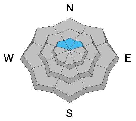
Areas of MODERATE avalanche danger still exist on upper elevation northerly facing slopes for triggering an avalanche that breaks into old faceted snow. Recent warm weather has strengthened the snowpack, but triggering an avalanche on old weak snow near the ground remains possible. Other upper elevation slopes have a MODERATE danger due to wind drifted snow.
Low and mid elevations have generally safe avalanche conditions and a LOW danger.
Low
Moderate
Considerable
High
Extreme
Learn how to read the forecast here
Special Announcements
Thanks to the generous support of our Utah ski resorts and Ski Utah, we have discount lift tickets available. All proceeds support the UAC. Get your tickets HERE.

Get one of these cool t-shirts to support the UAC and other avalanche centers across the U.S. INFO
Weather and Snow
This morning under clear skies, temperatures dropped into mid 20s F and into the teens F above 9000 feet. Winds were generally calm yesterday but increased this morning at the highest elevations blowing from the southwest 10-15 mph and gusting 20-25 mph. Despite some sunshine yesterday the snow on south aspects remained dry.
Sunday's snowfall totaled 2-8 inches of snow (0.4-0.72 inches of water).
Today a ridge of high pressure will slowly move eastward over Utah bringing warm temperatures in the upper 20s and low 30s F. Westerly winds should decrease today and blow about 10 mph. Skies will have some clouds this morning but generally plenty of sunshine. Looking ahead, a small disturbance comes tomorrow but shouldn't produce much snow. Later this week and into the weekend, a steady westerly & northwesterly flow with embedded disturbances will bring more snow through the weekend. This weekend should have fairly cold temperatures.
Recent Avalanches
Some shallow wind slabs were triggered by ski patrols yesterday.

In the Bear River Range just north of the border into Idaho, two snowmobilers on Saturday were caught and carried with one partial burial in an avalanche but ended up ok. INFO.
Ad
Avalanche Problem #1
Persistent Weak Layer
Type
Location
Likelihood
Size
Description
Old faceted snow does exists at the highest elevations. In many places you have to near 9000 feet to find it near the ground. This layer has been found near Snowbasin, near Powder Mountain, on Ben Lomond, and in the Monte Cristo area. No avalanches or cracking/collasping have been reported on this layer. For now we are watching this layer. Many people are digging to the ground (which is easy to do) to look for it and performing stability tests on it.

I was near Powder Mountain on Sunday and this layer propagated a crack just as it does in the video below from Doug Wewer on Ben Lomond Peak. For now, its a waiting game to see if additional loading and snowfall coming this weekend will activate this layer and cause avalanches. The long term prospects are good that this layer may heal and go away.
Avalanche Problem #2
Wind Drifted Snow
Type
Location
Likelihood
Size
Description
Sunday's new snow was transported by northerly winds early Monday morning and by westerly winds this morning. Local ski patrols triggered a few shallow wind slabs yesterday. Simply look for signs of wind drifted snow which looks rounded and smooth at upper elevations. Also, look for slopes that were scoured or eroded and consider where that snow was transported. The simple strategy is to look for and avoid these slabs of freshly wind drifted snow at mid and upper elevations.
General Announcements
This information does not apply to developed ski areas or highways where avalanche control is normally done. This forecast is from the U.S.D.A. Forest Service, which is solely responsible for its content. This forecast describes general avalanche conditions and local variations always occur.