Join us at our 2nd Annual Blizzard Ball

Forecast for the Ogden Area Mountains

Evelyn Lees
Issued by Evelyn Lees on
Sunday morning, November 26, 2017

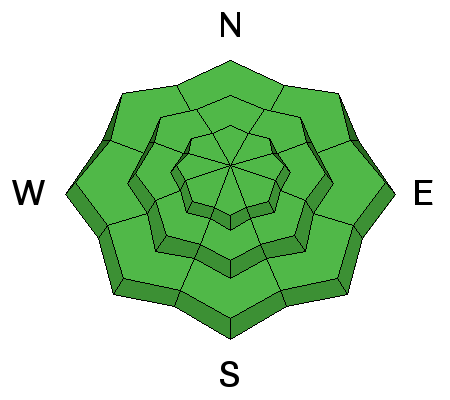
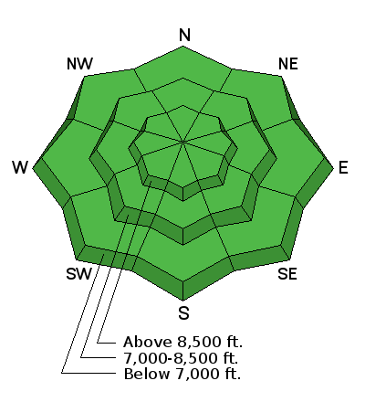
The avalanche hazard is LOW. With a couple of possible small storms early this coming week, the hazard may elevate due to fresh storm snow as well as possible wind drifting. On the highest upper elevation northwest through northeast aspects in the Ogden area mountains, there could be lingering weak faceted snow in isolated places near the ground, which could create a persistent slab hazard. Remember - a low avalanche hazard doesn't mean no avalanches.

We will continue with intermittent advisories until we begin to receive more snow.
Low
Moderate
Considerable
High
Extreme
Learn how to read the forecast here
Special Announcements

Unopened ski area terrain has a backcountry snowpack, as avalanche mitigation work has not been done. Each resort has different uphill travel policies - please abide by signage and closures and check in with the local ski patrol.

Weather and Snow

Conditions as of 3 pm Sunday afternoon feature very mild temperatures with increasingly strong south and southwest winds. Temperatures along the high ridge lines are in the mid 40's F, and winds are averaging in the 30s and 40s, with gusts over 50 mph from the south.

A rain event to the tops of the ridge lines early last week, along with very warm temperatures over the Thanksgiving holiday, have crusted most snow surfaces. Southerly through westerly aspects have melted off, with patches of snow clinging to northerly aspects above about 8500' - about 12" of snow or a bit more.

At the bottom of this observation are a few photos of snow coverage I took today.

Recent Avalanches

There has been no reported recent avalanche activity in the Ogden area mountains.

Ad
Avalanche Problem #1
Normal Caution
Type
Location
Likelihood
Size
Description

The snowpack is currently stable and avalanches are unlikely. However, with a couple of possible weather systems early this week, the avalanche hazard may elevate:

  • 3-6" of snow are expected Monday afternoon creating possible shallow storm slab avalanches.
  • Moderate to strong winds first from the south/southwest, and then shifting to the northwest on Monday afternoon may create fresh, sensitive wind drifts at the mid and upper elevations.
  • Currently, any remaining faceted snow would be only at the highest elevations, probably above about 9,000'. These weaknesses are dormant. But persistent weaknesses could show their hand with new loading such as storm snow and/or wind deposited snow.

Although any storm slabs or wind drifts will be quite shallow, they may pack a bit more punch than expected due to the slick, icy bed surface. Remember, even a short ride on our thin snowpack will mean a ride over rocks and stumps surface.

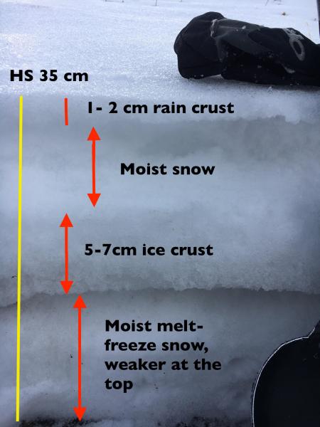
Here is a look at the "snowpack" on a northerly facing slope, 8800'. Lots of variability over short distances in the shallow, Ogden area snowpack.


Additional Information

Cloudy, windy, and mild through early Monday afternoon when we can expect a quick-hitting storm that may bring 3-6" on a northwest flow. Clearing Monday night followed by cool high pressure on Tuesday. Another quick-hitter is possible for Wednesday, with a few more inches of additional snowfall. Models are hinting at something more promising for late this coming weekend.

General Announcements

Remember your information can save lives. If you see anything we should know about, please help us out by submitting snow and avalanche conditions. You can also call us at 801-524-5304, email by clicking HERE, or include #utavy in your tweet or Instagram.

To get help in an emergency (to request a rescue) in the Wasatch, call 911.

If you trigger an avalanche in the backcountry, but no one is hurt and you do not need assistance, please notify the nearest ski area dispatch to avoid a needless response by rescue teams. Thanks.

Utah Avalanche Center mobile app - Get your advisory on your iPhone along with great navigation and rescue tools.

To those skinning uphill at resorts: it is critical to know the resort policy on uphill travel. You can see the uphill travel policy for each resort here.

Benefit the Utah Avalanche Center when you shop from Backcountry.com or REI: Click this link for Backcountry.com or this link to REI, shop, and they will donate a percent of your purchase price to the UAC. Both offer free shipping (with some conditions) so this costs you nothing!

Benefit the Utah Avalanche Center when you buy or sell on ebay - set the Utah Avalanche Center as a favorite non-profit in your ebay account here and click on ebay gives when you buy or sell. You can choose to have your seller fees donated to the UAC, which doesn't cost you a penny.

This information does not apply to developed ski areas or highways where avalanche control is normally done. This advisory is from the U.S.D.A. Forest Service, which is solely responsible for its content. This advisory describes general avalanche conditions and local variations always occur.