Forecast for the Ogden Area Mountains

Drew Hardesty
Issued by Drew Hardesty for
Monday, January 8, 2024
A CONSIDERABLE avalanche danger exists on nearly all steep slopes, even at the low elevations. You will be able to trigger avalanches 1-2' deep at a distance, even from below. THESE ARE DANGEROUS AVALANCHE CONDITIONS. Be careful out there, folks. Remember, if you area headed out of bounds at a ski area, you are heading into very dangerous terrain!
Low
Moderate
Considerable
High
Extreme
Learn how to read the forecast here
Special Announcements
New UAC Product! Sign up HERE for forecast region-specific text message alerts. You will receive messages about changing avalanche conditions, watches, and warnings.

Weather and Snow
Skies are partly cloudy.
Winds are generally light from the north, blowing 10-15mph with gusts to 25. Along the highest elevations, the winds are blowing 20-25mph with gusts to 35.
The Ogden mountains got walloped with heavy snowfall Saturday night into early Sunday with 15" (0.75"SWE) consistently along the Ogden skyline with up to a foot in the low elevations. Mountains east of Eden picked up 8-12".
For today, we'll have partly cloudy skies, light winds from the northwest, and temps in the single digits. Increasing clouds tonight.
For tomorrow and through the end of time, I'll only remind you, Be careful what you wish for. We have a very active weather pattern on deck with a series of storms starting tomorrow afternoon. Temperatures warm to the upper teens to low 20s tomorrow as the westerly winds (from the west) amp up and become strong Tuesday afternoon. Light snowfall should begin midday. By the end of the weekend, we'll be measuring the snowfall in terms of feet, not inches.
Recent Avalanches
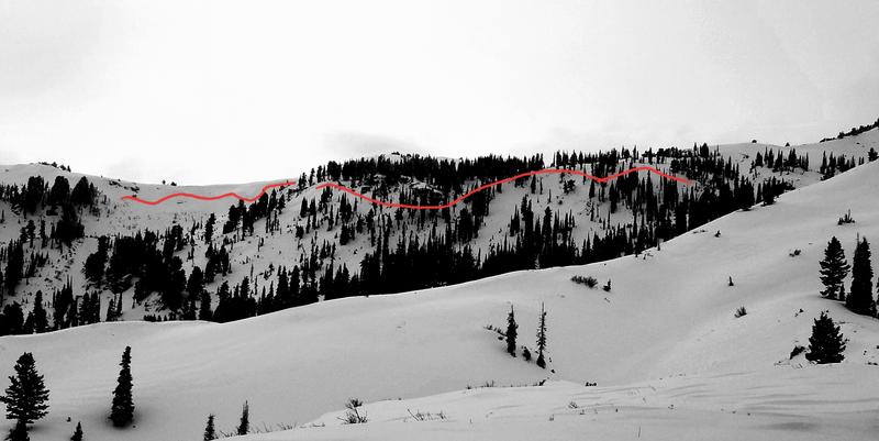
Wow! Heavy snowfall and moderate to strong winds led to very active avalanche conditions yesterday along the Ogden skyline. A large natural slab avalanche released wall to wall along the Bailey Spring area just south of the Ben Lomond headwall. Observer Derek DeBruin estimated it as almost 2' deep and 2500' wide. This was on a steep northeast facing slope at 8600'. (pic below) Derek and snow safety teams from Nordic Valley remotely triggered soft slabs up to a foot deep as low as 5700'! We also received a report that an avalanche had run onto road along the North Ogden Divide. All elevations were active. Many aspects were active. And dangerous.
See all the reports HERE.
Ad
Avalanche Problem #1
Persistent Weak Layer
Type
Location
Likelihood
Size
Description
You will still be able to trigger avalanches 1-2' deep on our December drought layer of facets PWL (persistent weak layer) at all elevations. We finally have enough of a slab (snow and/or wind) to over load these very weak weak layers on many aspects and you'll be able to trigger them - even at a distance - today. Collapsing and cracking are key indicators of instability but for now you should know that we have dangerous avalanche conditions.
Avalanche Problem #2
Wind Drifted Snow
Type
Location
Likelihood
Size
Description
You'll find sensitive soft slabs of wind drifted snow on a variety of aspects and primarily (but not exclusively) in the upper elevations. Winds blew moderate to strong from the southwest prior to frontal passage Saturday night and then shifted to the northwest yesterday. They have been blowing in the moderate category from this direction ever since with more than enough snow to transport into cohesive slabs. Avoid these rounded rippled whales of wind blown snow. Shooting cracks are a tell-tale sign of instability. ⚠️ They may also break out above you on a slope.
General Announcements
This information does not apply to developed ski areas or highways where avalanche control is normally done. This forecast is from the U.S.D.A. Forest Service, which is solely responsible for its content. This forecast describes general avalanche conditions and local variations always occur.