31st Annual Backcountry Benefit - September 12th - Tickets Available Here!

Forecast for the Ogden Area Mountains

Trent Meisenheimer
Issued by Trent Meisenheimer on
Sunday morning, January 7, 2024
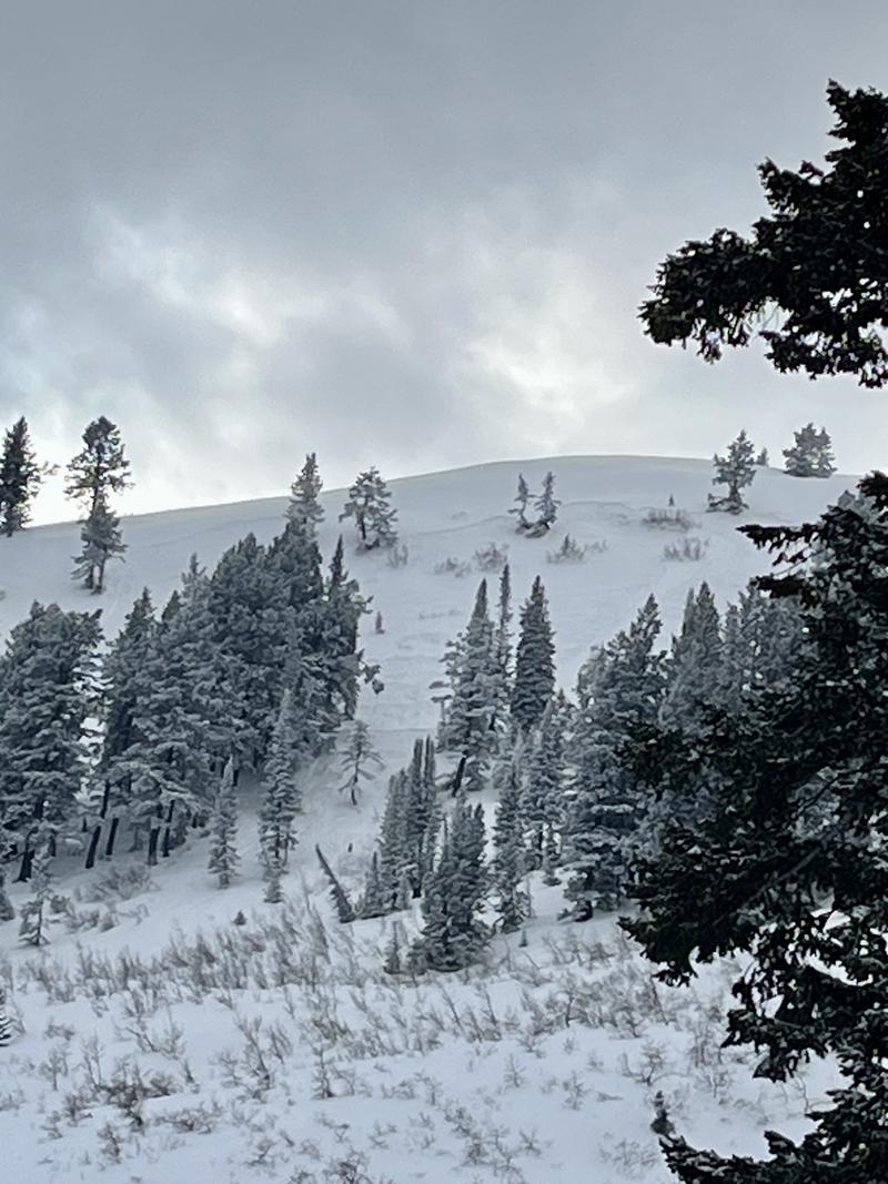
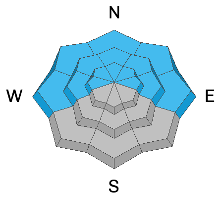
Update: 9:32 AM: The avalanche danger is HIGH across the upper elevation northerly facing terrain. There is also a CONSIDERABLE danger on low to mid-elevation slopes facing west to north and east. On these aspects and elevations, you'll want to avoid slopes where the wind has drifted the snow, forming either hard or soft slabs over our very weak and faceted snow. Avalanches can easily break 1-2 feet deep and over 100 feet wide.

Traveling in avalanche terrain is NOT recommended. Dangerous avalanche conditions exist. Careful snowpack evaluation, cautious route-finding, and conservative decision-making will be essential today. Natural avalanches are possible; human avalanches are likely.
Low
Moderate
Considerable
High
Extreme
Learn how to read the forecast here
Special Announcements
New UAC Product! Sign up HERE for forecast region-specific text message alerts. You will receive messages about changing avalanche conditions, watches, and warnings.
Weather and Snow
The next storm has arrived. It's snowing in the mountains, and in the last 12 hours, we've picked up 9-14 inches of new snow (0.37-0.80" water). This brings our storm totals to roughly 12-20 inches of new snow since Thursday (0.57-1.1" water). The storms have favored the Ogden Skyline, where they have received the lion's share of snowfall.
Current mountain temperatures remain cold and range from single digits to the upper teens Fahrenheit. Winds overnight blew out of the southwest at elevated speeds of 20-30 mph with gusts into the 40s across the upper elevation ridgelines. This morning, the winds slowed and veered to the northwest as the cold front moved overhead. Winds now blow 5-15 mph, gusting into the 20s.
Today's heaviest snowfall is expected this morning with the frontal passage, where we could see the heaviest snowfall rates. Mountain temperatures will climb into the 14-17 °F range. Winds will be from the west-north-west and are forecast to blow 10-20 mph with gusts into the 20s.
The storm will diminish overnight tonight, with lingering snow showers into Monday. When all is said and done, we could see an additional 5-10 inches of new snow.
Recent Avalanches
Avalanche activity yesterday was confined to shallow, soft, and hard slabs of wind-drifted snow that failed on faceted snow. There were three avalanche observations from yesterday and the one that stood out to me was a natural avalanche off Chili Peak (photo below)
Ad
Avalanche Problem #1
Wind Drifted Snow
Type
Location
Likelihood
Size
Description
Yesterday's southwest winds changed the game. Overnight, these winds blew for roughly 12 hours at elevated speeds in the 20-35 mph range. We now have a slab over fragile, faceted snow (bad setup). The avalanche on Chili Peak is the perfect example of this. Today, we are adding more snow (weight) and wind (northwest winds) to our snowpack. It's only a matter of time before everything avalanches.
These soft or hard slabs of wind-drifted snow could be 1-2' deep and over 100' wide. Cracking and collapsing are bulls-eye clues to unstable snow. Basically, if you find a place where the snow has a little slab structure, it will be electric, and very surprising how fast it can avalanche. It's a gamble, SLAB or NO SLAB. And the bet, broken bones, or worse. I would play it safe and stick to slopes under 30 degrees with nothing steep above or adjacent to me. You can trigger avalanches from a distance today.
Avalanche Problem #2
New Snow
Type
Location
Likelihood
Size
Description
As the low-density snowfall continues to stack up, there are two concerns here:
  1. Soft Slab Avalanche: This avalanche can fail within the new storm snow (density changes), or if you're on northerly facing terrain, it can fail at our old snow surface that is made up of weak and faceted snow. With 14 inches of new snow at 6,000 feet, I would also be very cautious of the lower elevations today. Here avalanches can fail on very weak faceted snow.
  2. Dry-Loose Avalanches (sluffs): These can be surprisingly fast and can run long distances. Right now, they also gouge into the underlying weak snow making them a bit more pushy.
Avalanche Problem #3
Persistent Weak Layer
Type
Location
Likelihood
Size
Description
Over the past month, we've seen very little snowfall, mainly clear skies and cold temperatures. This has created very weak and faceted snow across Utah. Unfortunately, this weak snow is now buried and preserved. With more snowfall and wind loading (weight) added to our snowpack, it will only be a matter of time before avalanches start breaking deeper into the snowpack creating a much larger and more dangerous avalanche.
Video: Trent Meisenheimer talking about the current snow structure and what we can expect.
General Announcements
This information does not apply to developed ski areas or highways where avalanche control is normally done. This forecast is from the U.S.D.A. Forest Service, which is solely responsible for its content. This forecast describes general avalanche conditions and local variations always occur.