Join us for the 33rd Backcountry Benefit - Get Your Tickets Now!

Forecast for the Ogden Area Mountains

Nikki Champion
Issued by Nikki Champion on
Wednesday morning, January 7, 2026

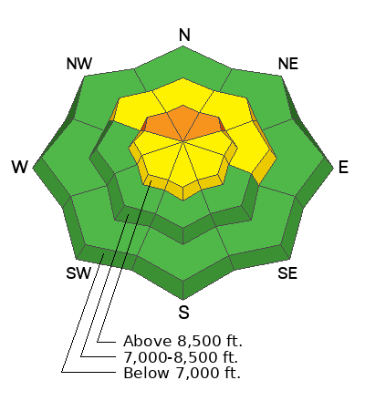
The avalanche danger is CONSIDERABLE on upper-elevation aspects facing NW‑N‑NE, where human-triggered avalanches are likely and natural avalanches are possible. Avalanches may fail one to three feet deep in new or wind-drifted snow, but can also step down to weak layers buried deeply on northerly slopes.

The remaining upper-elevation aspects, and mid-elevation aspects facing NW-N-E, have a MODERATE danger, where human-triggered avalanches remain possible. Clear skies and soft snow may tempt riders, but the snowpack remains dangerous. Avalanche terrain can be avoided, and excellent riding exists on lower-angle slopes (under 30°).

People venturing out of bounds at ski areas face the same dangerous conditions.
Low
Moderate
Considerable
High
Extreme
Learn how to read the forecast here
Special Announcements

Be mindful of avalanche workers - IF YOU TRIGGER an avalanche near a ski area, please report it to the ski patrol dispatch or Alta Central (801-742-2033). Rescue personnel don’t want to be subjected to dangerous conditions if the scene is clear. More on this in Backcountry Emergency Protocols

Weather and Snow

This morning, skies are partly cloudy with temperatures in the upper 20s to low 30s °F. Winds are out of the southwest, averaging in the 20s to 30s mph, with gusts reaching up to 40 to 60 mph along exposed mid and upper elevation ridgelines.

Today, skies will stay partly cloudy and deteriorate slightly ahead of the incoming storm. Temperatures will hover in the low 30s °F. Winds shift more west southwesterly this afternoon, with wind speeds averaging 10–15 mph along exposed mid and upper elevation ridgelines, with gusts up to 40 mph. Snow could begin as early as this afternoon, but remain light, with possible accumulation up to 1-4 inches by 5 PM. The main push of the storm arrives this evening.

This system looks more traditional, bringing colder temperatures and lower-density snowfall. Confidence is high for snow along and just behind the cold front, though uncertainty in storm timing and density still impacts final snowfall and SWE totals. Current projections range from 8-14 inches of snow, with up to 0.80 inches of water.

Recent Avalanches

No new avalanches were reported for the Ogden area. Ski resorts reported less sensitive snow than the day prior.

South of Ogden in the Salt Lake Area mountains it was a busy day for avalanche observations. Since Sunday, most avalanches have been soft slabs of new or wind-drifted snow failing on or within the Christmas Eve rain crust, a pattern mirrored by ski resorts through reactive control. Occasionally, avalanches step deeper into weak snow near the ground.

Yesterday, a hard slab near Oingo Boingo (10,200’ north-facing) was 70 feet wide, 2.5 feet deep, and ran roughly 400 feet vertical, stepping immediately into facets—similar to Sunday’s Two Dogs avalanche.

On Tuesday, a snowmobiler triggered a very large hard slab at First Cornice, averaging 4 feet deep and up to 7 feet near the cornice. Brooke and Trent confirmed it failed on small-grain facets above the Christmas Eve rain crust, without stepping deeper into older snow.

Read all backcountry observations here.

Avalanche Problem #1
Wind Drifted Snow
Type
Location
Likelihood
Size
Description

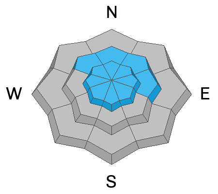
Overnight, winds have been gusting up to 60 mph at the highest peaks. These moderate to strong west-southwest winds will continue to drift snow primarily onto leeward north and east-facing aspects, although with such strong winds, cross-loading is likely today. This means snow could drift onto all aspects. Watch for cracking as an indication of sensitive, fresh wind drifts.

With multiple days of elevated winds, these drifts will continue to become more stout and supportable, potentially allowing riders to travel farther onto slopes before seeing obvious red flags.

Recent slabs of wind-drifted or new snow may step down 1-2'+ feet into the Christmas Eve rain crust (CERC), and could also step deeper into older facets near the ground, with avalanches exceeding 3+ feet possible.

See Greg's video below showing some drifting along the Ben Lomond Ridgeline, and talking about the snowpack and depth he found on his tour yesterday.

Avalanche Problem #2
Persistent Weak Layer
Type
Location
Likelihood
Size
Description

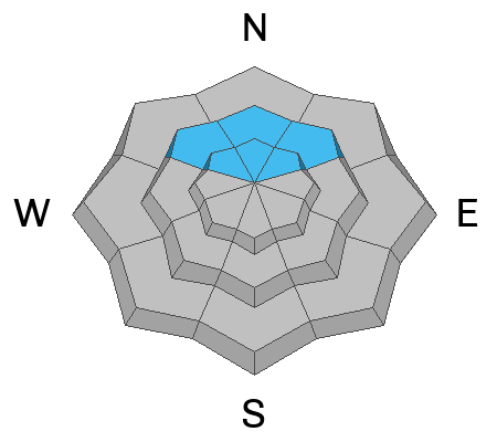
Yesterday, Greg was traveling Culter Ridge and found an overall strong snowpack structure, though uncertainty still exists around the PWL above 8,500’ and the potential for facets forming around the Christmas Eve and New Year’s rain crust. While we haven’t seen activity on these layers recently in the Ogden area mountains, we have observed activity on both the facets above the crust and the facets at the ground in the Salt Lake area, and we know a similar structure exists at the upper reaches of Ogden.

These slides may be a warning that on many slopes with a persistent weak layer (PWL), the added weight of new and wind-driven snow could be enough to trigger larger avalanches in the Ogden area. The uncertainty of the pattern and locations should give pause.

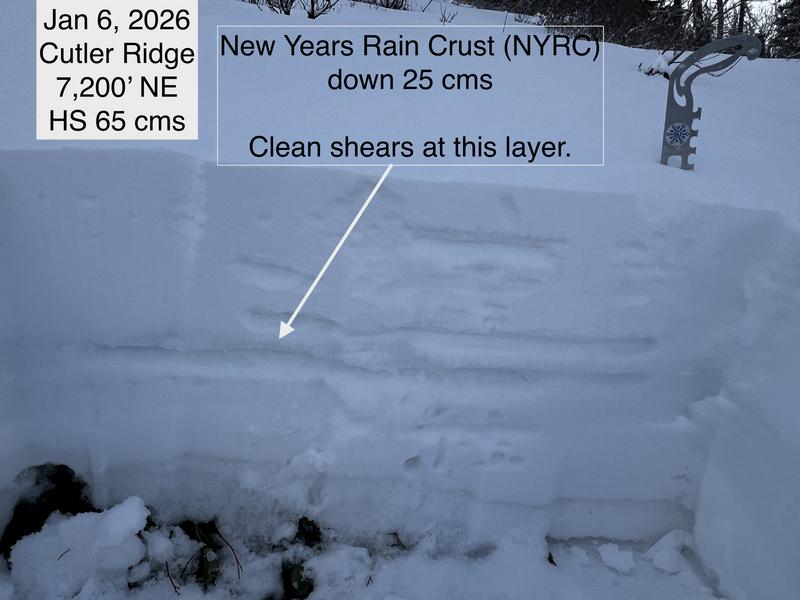
Between 7,500 and 8,500’, the New Year’s Rain Crust (NYRC) has a layer of graupel. Greg was able to get some clean shears just above the NYRC, but also observed evidence of weaker crystals. Continue to watch for possible faceting above this crust.

For today, I’d continue to avoid traveling on, underneath, or adjacent to any slope approaching 30° or steeper on northwest, north, or northeast-facing aspects at upper elevations, where we’ve seen the most activity on this weak, faceted snow.

Additional Information

There have been four significant close calls in the Brighton backcountry this past week. Utah has the highest number of fatalities among skiers and riders who leave ski area boundaries. UAC Forecaster Drew Hardesty analyzed Utah accident data in a 2016 article for The Avalanche Review. These numbers predate the post-COVID surge in backcountry traffic.

General Announcements

This information does not apply to developed ski areas or highways where avalanche control is normally done. This forecast is from the U.S.D.A. Forest Service, which is solely responsible for its content. This forecast describes general avalanche conditions and local variations always occur.