Forecast for the Ogden Area Mountains

Drew Hardesty
Issued by Drew Hardesty for
Friday, January 4, 2019
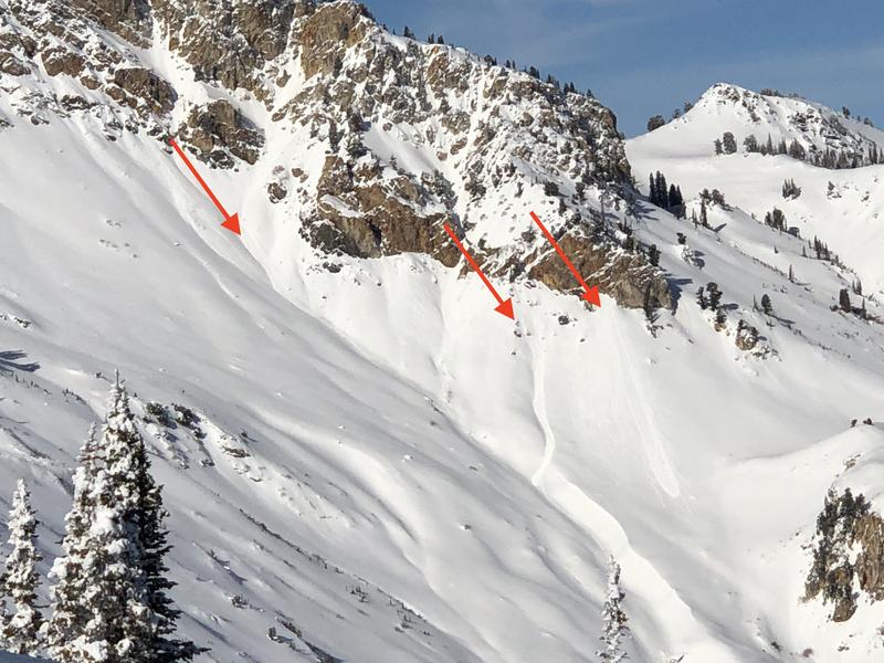
Today's avalanche danger is generally LOW. Minor wet and dry sluffs are possible on steep slopes. Remember that risk is inherent in mountain travel - even a small sluff can be significant in radical, no-fall terrain.
Low
Moderate
Considerable
High
Extreme
Learn how to read the forecast here
Weather and Snow
Skies are clear.
Mountain temperatures are in the upper 20s to low 30s with basins and trailheads in the teens.
West to southwest winds blow 10-15mph with gusts to 20.
It's easy to avoid the wind and sun damage by heading to the sheltered shady slopes. There, skiing and riding conditions remain excellent where surface faceting and the glittery diamonds of surface hoar abound. (pc Kory Davis)
As they say, "Today's snow surface is tomorrow's buried weak layer." Let's see how well this loose and weak surface snow is preserved prior to Saturday night's storm system. If well preserved, there's gonna be trouble. Stay tuned.
Recent Avalanches
Minor wet loose avalanche activity was reported in the off Willard Peak and the sun-drenched aspects above Cutler Creek. (pc: Greg Gagne)
Ad
Avalanche Problem #1
Normal Caution
Type
Location
Likelihood
Size
Description
Normal caution is warranted if in steep sun-drenched terrain well after the snow surface has thawed and become unconsolidated. Minor loose wet and - on the northerly aspects - loose dry sluffs may be expected.
Many of our forecasters and pro observers have found mostly stable conditions in the Ogden area mountains. There are plenty of excellent reports to sift through here.
Additional Information
The forecasts have a decent storm system slated for Saturday night into Monday. At this stage of the game, I'd count on at least 6-10" of snow with moderate to strong westerly winds. The avalanche danger will rise accordingly.
For today, we'll have mostly sunny skies, light to moderate southwest winds, and mountain temps into the mid-30s to low 40s. Enjoy -
General Announcements
This information does not apply to developed ski areas or highways where avalanche control is normally done. This forecast is from the U.S.D.A. Forest Service, which is solely responsible for its content. This forecast describes general avalanche conditions and local variations always occur.