Forecast for the Ogden Area Mountains

Greg Gagne
Issued by Greg Gagne for
Tuesday, January 22, 2019
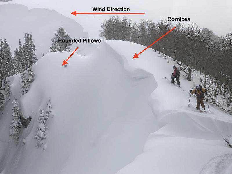
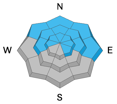
The avalanche hazard is CONSIDERABLE at the upper elevations, as well as mid and lower elevations facing northwest through east. Low and mid elevations facing west through southeast have a MODERATE hazard. The primary avalanche hazard for today is fresh wind drifts, especially along upper elevation ridgelines. At low and mid elevations there remains the isolated possibility of triggering an avalanche on a buried layer of weaker snow, especially on steep, shady aspects.
Low
Moderate
Considerable
High
Extreme
Learn how to read the forecast here
Special Announcements
On Friday, a skier was killed in an avalanche near Electric Lake on the Manti/Skyline Plateau. Their body was recovered Saturday morning. You can read the updated report - including photos and video from the accident site - by clicking here. The UAC extends our deepest condolences to their family and friends.
Weather and Snow
Mountain temperatures are in the upper single digits and winds are out of the north/northeast, gusting in the 20's and 30's mph at the mid and upper elevations.
Storm totals in the Ogden mountains range from 4-8", with 0.5" to 0.75" of water.
For today you can expect partly cloudy skies and temperatures in the mid teens F. Winds will be northerly, gusting in the 20's and 30's at the upper elevations, although diminishing as the day progresses.
A weak system later Wednesday may deliver a few inches of snow.
Recent Avalanches
No backcountry observations were received for the Ogden mountains from Monday. Mitigation and control work from snow safety teams reported shallow storm slabs during the day.
You can find all observations - including recent avalanche activity - for the Ogden mountains by clicking here.
Ad
Avalanche Problem #1
Wind Drifted Snow
Type
Location
Likelihood
Size
Description
Northerly winds have persisted for the past 24 hours in the Ogden mountains, creating pockets of wind drifted snow primarily at the upper elevations, but also some exposed mid elevation locations. Yesterday's storm snow will provide loose snow available for transport as moderate winds continue to blow today.
Avoid recent and fresh wind drifts by watching for evidence of wind drifted slopes such as rounded pillows of snow. Also avoid fresh cornices along ridgelines, especially on aspects facing north through south.
The photo below illustrates the windward direction (from right to left) which creates fresh cornices along the ridgeline, as well as rounded pillows of snow on the lee side of the windward ridges.
Avalanche Problem #2
New Snow
Type
Location
Likelihood
Size
Description
Although the Ogden mountains recorded only 4-8" of snow from Monday's storm, you may find sensitive storm slabs, especially at the upper elevations that received the most snow, as well as dry, loose sluffs.
Finally, clouds, cool temperatures, and winds should keep the snow surface cool, but watch for any evidence of warming on solar aspects including rollerballs and wet, loose sluffs.
Avalanche Problem #3
Persistent Weak Layer
Type
Location
Likelihood
Size
Description
While the faceted weak layers in our snowpack continue to gain strength and adjust to the recent loading of storm and wind-driven snow, they still cannot be completed trusted. Several observations from the Ogden mountains have indicated preserved near-surface facets and surface hoar (such as the recent avalanche activity on Cutler Ridge), and these weaknesses may be reactive to this new load of storm snow. The rime crust that formed on Saturday complicates this picture, with a possible weak layer on top of the crust. Pay careful attention to being below steep slopes, especially in shady low-elevation terrain. Photo below is recent avalanche failing on layer of faceted snow on northeast aspect at 7000'
General Announcements
This information does not apply to developed ski areas or highways where avalanche control is normally done. This forecast is from the U.S.D.A. Forest Service, which is solely responsible for its content. This forecast describes general avalanche conditions and local variations always occur.