UDOT PLANNED AVALANCHE CLOSURES!!

Forecast for the Ogden Area Mountains

Greg Gagne
Issued by Greg Gagne for
Friday, January 20, 2023
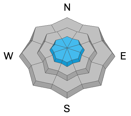
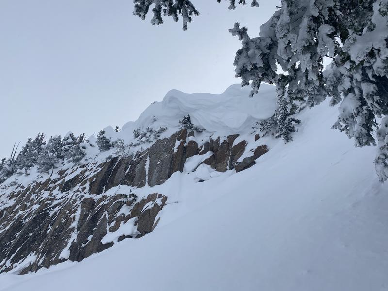
The avalanche danger is MODERATE at the upper elevations where you may find pockets of sensitive wind-drifted snow. Avoid traveling underneath or along the edge of corniced ridgelines as large cornices may easily break off. Long-running sluffs are also possible in steep terrain.
There is a LOW danger at mid and low elevations.

Before kicking a cornice, performing a ski cut, or dropping onto a steeper slope, watch for others below you.
Low
Moderate
Considerable
High
Extreme
Learn how to read the forecast here
Weather and Snow
This Morning: Skies are partly cloudy and temperatures range through the teens. Winds are out of the east (an odd direction for us) and generally light, less than 10 mph, although a few locations are reporting gusts in the 20's mph. Many locations picked up an inch or two of snow Thursday afternoon.
Today: One to savior. Partly cloudy skies with temperatures rising into the teens and low 20's F. Winds will be out of the east/northeast and remain light, with gusts near 20 mph at the upper elevations.
This Weekend: Mostly sunny on Saturday with temperatures in the 20's F. There is a decent chance of picking up a few inches of low-density snow on Sunday afternoon.
Looking ahead, we can expect perfect powder-preserving weather as northern Utah will remain under a cold northerly flow for much of this coming week with a few chances of light snowfall.

Snowfall and total snow depths for the last two weeks
  • Ogden Area Mountains- 75-78" snow (snow depth 90-110")
  • Park City Ridgeline 75-113" snow (snow depth 90-105")
  • Upper Cottonwoods- 100-115" snow (snow depth 125-160")
  • Provo Area Mountains 90-92" snow ( snow depth 80-115")
Recent Avalanches
Dereke DeBruin has a good observation from the Ogden Divide on Thursday. The only avalanche activity from Thursday involved minor sluffing in the cold, dry snow on steep slopes and small, shallow wind slabs in the upper elevations.
Ad
Avalanche Problem #1
Wind Drifted Snow
Type
Location
Likelihood
Size
Description
Watch for isolated wind drifts on all aspects in the upper elevations. Although light winds are forecast, there is an abundance of cold, dry powder that can easily be drifted into sensitive soft slabs of wind-drifted snow. Winds will also be from an easterly direction and this is unusual for us; I always raise my guard a notch when the winds are from the east as this can create some unexpected loading patterns.
I think the current greatest wind-related hazard is the large cornices that adorn many upper-elevation ridgelines, such as shown in the photo below on Sunset Peak (photo: Funk) in the Salt Lake mountains. Avoid traveling underneath these cornices as they may brake off naturally or from a human traveling above. Also avoid traveling close to corniced ridgelines as they may break back further than expected.
Forecaster Comments: This is a great time to get after the bigger objectives you've been waiting for: generally stable avalanche conditions, great coverage, and brilliant riding. If you do choose to pursue these bigger objectives, evaluate the slopes for recent wind drifts and watch for large cornices that guard the entrances to many slopes. Before kicking a cornice, performing a ski cut, or dropping onto a steeper slope, watch for others below you.
Additional Information
What happened to the persistent weak layer problem? Nikki Champion and Dave Kelly talk about the team's decision to drop the Persistent Weak Layer as a listed problem.
Be in the Know - follow our partners @UDOTavy for backcountry and road closure information on Twitter and Instagram.
General Announcements
This information does not apply to developed ski areas or highways where avalanche control is normally done. This forecast is from the U.S.D.A. Forest Service, which is solely responsible for its content. This forecast describes general avalanche conditions and local variations always occur.