Join us at our 2nd Annual Blizzard Ball

Forecast for the Ogden Area Mountains

Dave Kelly
Issued by Dave Kelly on
Tuesday morning, January 14, 2025
The avalanche danger is MODERATE at mid and upper elevations and LOW in the lowest elevation terrain. It will be possible for humans to trigger avalanches 1'-3' deep and up to 200' wide in thin rocky zones or in areas where avalanches have already occurred this season.
With a buried Persistent Weak Layer as the primary avalanche problem, cautious route finding and conservative decision making are essential.
Low
Moderate
Considerable
High
Extreme
Learn how to read the forecast here
Special Announcements
Receive forecast region text message alerts about changing avalanche conditions, watches, and warnings. Sign up HERE.
Weather and Snow
Under partly cloudy skies, temperatures are in the teens °F. Winds are blowing 10 gusting to 20 MPH from the north at the lower ridgelines and from the north in the mid 20's gusting to the 30's MPH at the highest ridgelines. It is COLD again this morning and the wind chill in many locations is well below 0 °F. 24-hour snowfall numbers added another 1"-2" of snow and .10" of water. Snow depths throughout the region vary from 40"-60".
For today, look for partly sunny skies. Temperatures will be between 22-26 °F with light winds from the north 5 gusting to 10 MPH at the lower ridgelines and 25 gusting to 35 MPH at the highest ridgelines.
You can find soft surface snow on all aspects to make turns, which makes it easy to stay away from the steeper aspects that are holding weaker faceted snow near the ground.
Recent Avalanches
Yesterday, there were no backcountry avalanches reported to the UAC from the Ogden Region. Ski area operations reported shallow wind drifts during the day.
Check out all observations and avalanches HERE.
Ad
Avalanche Problem #1
Persistent Weak Layer
Type
Location
Likelihood
Size
Description
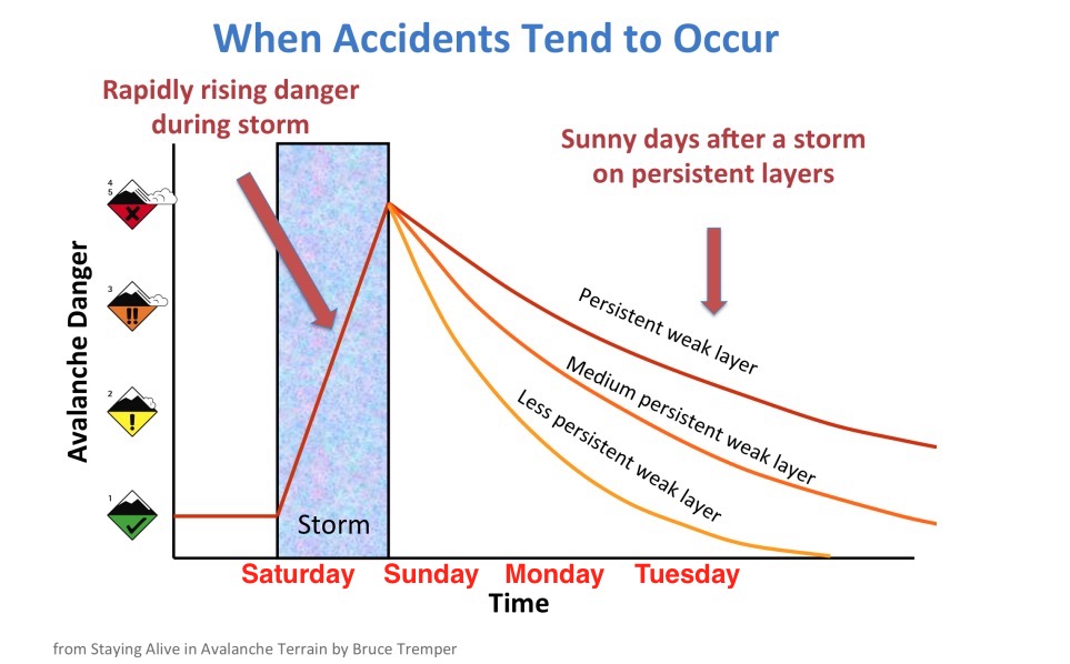
The buried weak layer of faceted snow (PWL) is still intact on many aspects facing northwest-north-east. Locations where you are more likely to trigger an avalanche failing into these dry loose facets are thin rocky terrain, and on slopes that have already avalanched this season (repeaters).
Avalanche Problem #2
Wind Drifted Snow
Type
Location
Likelihood
Size
Description
In the Ogden Area Mountains, there is new snow available for transport. With shifting winds throughout the storm and increased wind speeds overnight and this morning expect to see shallow drifts on all aspects in upper and mid elevation terrain. Look for and avoid pillowy rounded areas of new snow and steep wind loaded slopes underneath newly formed cornices. Fresh wind drifts can also activate the buried persistent weak layer on slopes still harboring weak dry snow near the ground.
Additional Information
The avalanche danger scale is not linear, which means that the avalanche danger doesn't jump quickly between levels. It is a much more gradual change, and right now we are on the highest end of the MODERATE danger scale, which means that you may see travel advice that more closely matches what we would see during periods of CONSIDERABLE avalanche danger. The snowpack is solid MODERATE right now, but the human factor is always an unknown. Read more about the non-linear nature of the avalanche scale HERE.

Longtime avalanche forecaster Eric Trenbeath writes more about MODERATE danger with a buried persistent weak layer HERE.
General Announcements
This information does not apply to developed ski areas or highways where avalanche control is normally done. This forecast is from the U.S.D.A. Forest Service, which is solely responsible for its content. This forecast describes general avalanche conditions and local variations always occur.