Join us for the 33rd Backcountry Benefit - Get Your Tickets Now!

Forecast for the Ogden Area Mountains

Bo Torrey
Issued by Bo Torrey on
Tuesday morning, January 13, 2026

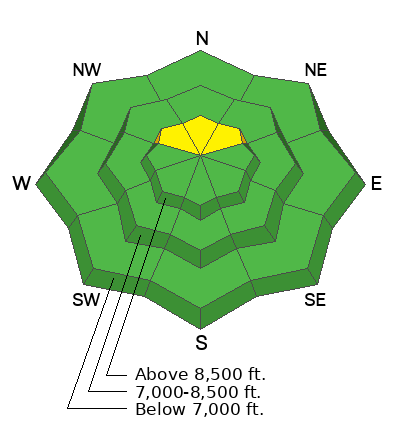
A MODERATE avalanche danger exists on upper elevation slopes facing NW-N-NE, where potential for human-triggered avalanches in isolated areas remains. Steep, rocky, or extreme terrain at upper elevations, where the snowpack depth is variable, is the most suspect.

Avalanche danger is LOW elsewhere. Small but predictable wet loose avalanches may release on sunny slopes with daytime warming. Avoid traveling in tight spaces or above features where being caught in a small avalanche would have outsized consequences.
Low
Moderate
Considerable
High
Extreme
Learn how to read the forecast here
Weather and Snow

Yesterday, skies were clear and daytime temperatures warmed into the upper 30s ˚ F. Wind blowing from the NW was light, 5-15mph with gusts in the 20s.

Today, temperatures warm into the low 40s ˚ F. Winds remain out of the NW and pick up slightly, 10-20 mph with gusts along exposed ridges into the 30s.

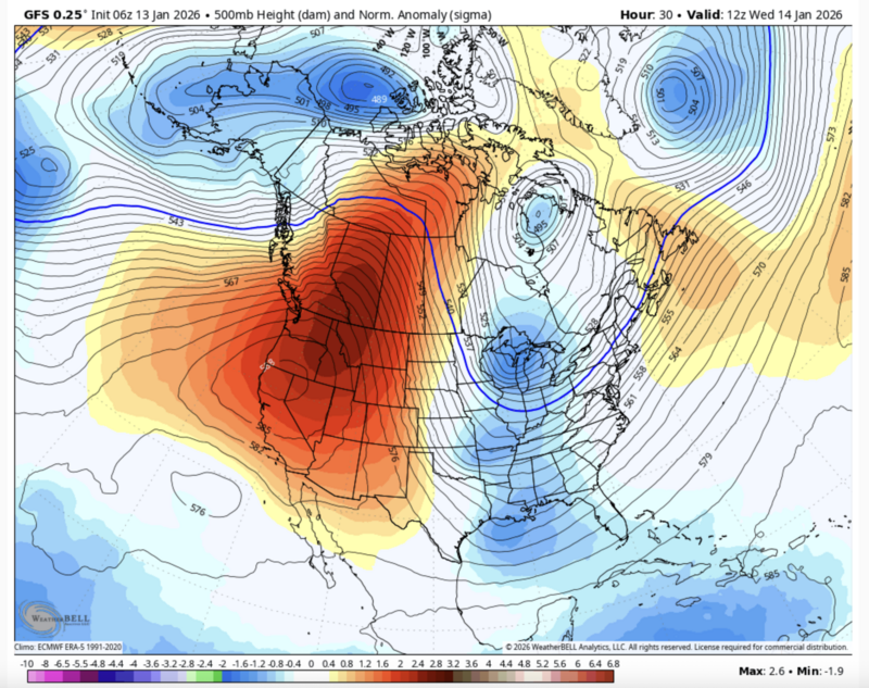
A ferocious mid-winter ridge stretching from Mexico to Northern Canada sits over the Western US and blocks our chance of precipitation for the next 7+ days. Rejoice in being in the mountains and out of valley inversion.

Recent Avalanches

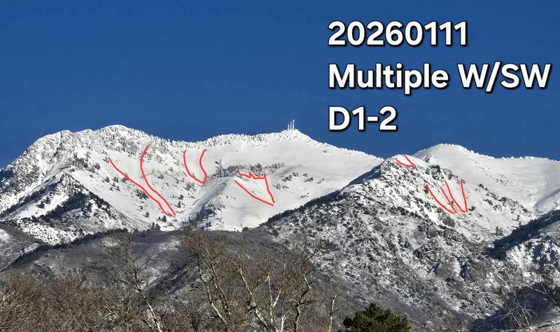
There were no new avalanches reported from Ogden on Monday. Wet-loose avalanche activity was reported from Sunday, including Derek DeBruin's observation from Mt.Ogden with large, wet-loose avalanches on aspects facing west through southwest.

We continue to receive many excellent, high-quality observations.

Avalanche Problem #1
Persistent Weak Layer
Type
Location
Likelihood
Size
Description

Recent field observations and reports from the Ogden area resorts indicate that, although there are facets at the base of the snowpack on upper-elevation northerly-facing slopes, the problem is going dormant. The most suspect terrain is steep, north-facing slopes at the upper elevations that have been recently wind-loaded.

Additional Information

Recent observations have highlighted some concerning travel trends in our zones. These comments aren't about judgment; they come from a place of shared concern for our community and everyone's safety.

It is a good time to refresh on the basics. Safe travel habits aren't just for 'high danger' days; they are the baseline techniques that reduce vulnerability for you and the groups around you.

The goal is margin. We treat safe travel as a strict, daily habit to build a margin for error. This ensures that even if the actual conditions turn out to be different than your assessment, your exposure to the consequences remains low.

  • Pick safe up tracks that utilize ridges and slopes less than 30 degrees.
  • One at a time- never expose more than one person at a time to avalanche-prone slopes
  • Travel with a partner- you can't dig yourself out. A good partner can help you make decisions and is essential if things go wrong.
  • Communicate- communication with your partners is the key to good decision-making.
  • Stay out of the way- Avalanches commonly flow into gentle, open terrain. Regroup in places where you're not exposed.
General Announcements

This information does not apply to developed ski areas or highways where avalanche control is normally done. This forecast is from the U.S.D.A. Forest Service, which is solely responsible for its content. This forecast describes general avalanche conditions and local variations always occur.