Forecast for the Moab Area Mountains

Eric Trenbeath
Issued by Eric Trenbeath for
Saturday, April 16, 2022
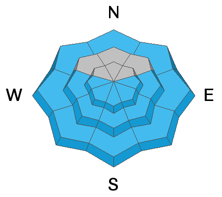
Most terrain has generally low danger. An isolated or MODERATE danger exists for human triggered avalanches involving wind drifted snow. Unstable slabs of wind drifted snow are most likely to be found on steep, upper elevation slopes facing NW through NE through SE. Recognizable by their smooth, rounded appearance, they may sound hollow underneath. Look for them on the leeward sides of ridge crests and terrain features such as gully walls and sub ridges.
As temperatures warm today be alert to signs of loose, wet instability such as rollerballs and pinwheels, and stay off of steep slopes if they become wet and sloppy.
Low
Moderate
Considerable
High
Extreme
Learn how to read the forecast here
Special Announcements
This weekend will see the end of regular avalanche forecasts.
Road Conditions: Bare dirt down low, mud and a few inches of rutted snow on the upper end.
Grooming: Done for the season.
Weather and Snow
7:00 a.m. weather data:
24 Hour Snow 0" 72 Hour Snow 0" Base Depth at Gold Basin 49" Wind SW 15-25 G30 Temp 36F
High and mid-level clouds have spread over the region ahead of a shortwave trough tracking across the Great Basin. A tight pressure gradient will produce strong SW winds in excess of 30-40 mph by this afternoon. High temps will be in the mid to upper 40's at 10,000'. The trough will pass over the region this evening producing light snow for mountain areas north of 1-70. Sunday will be sunny, warm, and breezy as high pressure builds to the west.
Snowpack
Wind and warm temperatures have created variable, springtime conditions and it may be difficult to find remnants of Tuesday's 8" out there. Most surfaces today will be sun and or wind crusted with the effects of the sun even creeping up into the higher north faces. Winds this week have blown and drifted snow on to leeward slopes though there has been less available for transport the past couple of days. Remain on the lookout for isolated wind slabs in the high country where even a small avalanche could be dangerous in consequential terrain. Clouds and wind today should slow down surface heating, but as things warm up you'll need to be alert to signs of loose wet instability such as rollerballs and pinwheels, and sloppy wet snow.
Gold Basin SNOTEL site (10,000')
Storm Totals in Gold Basin
Wind Station on Pre Laurel Peak (11,700')
Recent Avalanches
In our travels Wednesday we observed a natural wind slab release on a NE aspect above treeline. About a foot deep and isolated to the ridge crest, it was about 50' wide but it did manage to entrain loose snow and run nearly full track. We also observed evidence of numerous, loose, dry avalanches that ran during the height of the storm on Tuesday in very steep terrain.
Ad
Avalanche Problem #1
Wind Drifted Snow
Type
Location
Likelihood
Size
Description
Isolated, unstable slabs of wind drifted snow may still exist in the high country. Look for them on the leeward sides of ridge crests and terrain features such as gully walls and sub ridges. Drifts are recognizable by their smooth, rounded appearance, and cracking is a sign of instability. Even a small wind slab can be dangerous if triggered in consequential terrain.
Avalanche Problem #2
Wet Snow
Type
Location
Likelihood
Size
Description
As temperatures warm today, be on the lookout for signs of wet stability such as rollerballs, pinwheels, and sloppy wet snow. Get off of and out from under steep slopes if they become wet and sloppy.
General Announcements
Who's up for some free avalanche training? Get a refresher, become better prepared for an upcoming avalanche class, or just boost your skills. Go to https://learn.kbyg.org/ and scroll down to Step 2 for a series of interactive online avalanche courses produced by the UAC.
This forecast is from the U.S.D.A. Forest Service, which is solely responsible for its content. This forecast describes general avalanche conditions and local variations always occur.