Forecast for the Moab Area Mountains

Eric Trenbeath
Issued by Eric Trenbeath for
Thursday, April 13, 2023
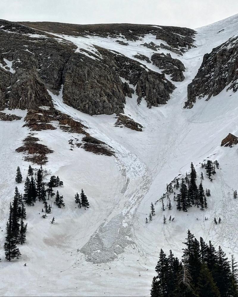
A MODERATE avalanche danger exists for loose wet avalanches on all aspects and elevations. Due to prolonged above-freezing temperatures and liquid water moving through the snowpack, there is also a possibility for larger, more destructive wet slab avalanches. Without a strong sun today, we are unlikely to see classic, red flag warnings such as roller balls and pinwheels, but punchy, wet, unconsolidated snow indicate potential instability.

Cornices are massive and with such warm temperatures, natural cornice fall is a real possibility. Give cornices, and slopes below, a wide berth.
Low
Moderate
Considerable
High
Extreme
Learn how to read the forecast here
Special Announcements
Sunday will be our last regularly scheduled daily forecast.
Geyser Pass Road: The road is mostly dry dirt with a few muddy patches.
Grooming: There are currently no more plans for grooming.
Weather and Snow
6:00 a.m. Snow and Weather Data
24 Hour Snow 0" 72 Hour Snow 0" Season Total Snow 315" Base Depth at Gold Basin 94"
Temp 37 F Winds on Pre-Laurel Peak: SW 30-35 G 40

Weather
Gusty SW winds are on the increase ahead of a low pressure system moving into the region. Look for increasing clouds and breezy SW winds blowing in the 25-35 mph range along ridge tops. High temps at 10,000' will be in the mid 40's. A chance for snow showers develops by late afternoon with 2"-4" possible by Friday morning. Overnight temps will drop to around 20°F. The system moves on Friday leaving partly cloudy skies and continued breezy conditions. A transient ridge builds over the weekend.
General Conditions
Conditions have taken quite a turn and it's hard to believe we were skiing powder a week ago. The recent heat wave has made a bit of a mess out of things. Hot powder conditions were reported on upper elevation, northerly aspects yesterday, while everywhere else has the consistency of a thick Slurpee. Without a strong sun today, the threat of wet avalanche activity will be tempered somewhat, but three consecutive nights without a re-freeze have left the snowpack in a volatile, and somewhat unpredictable state. If the threat of avalanches isn't enough to keep you off of steep slopes, then maybe generally poor conditions will. Personally, I'm going to wait until the weekend when a couple nights with a solid re-freeze, and favorable weather brings a chance for improved conditions.
Snowpack and Weather Data
Gold Basin Storm Stake (10,000')
Gold Basin SNOTEL site (10,000')
SNOTEL site near Geyser Pass Winter Trailhead (9600')
Wind Station on Pre-Laurel Peak (11,400')
NWS forecast for the La Sal Mountains.
Recent Avalanches
Mark White sent in this photo yesterday of a loose wet avalanche in Talking Mountain Cirque that likely ran on Wednesday afternoon. He noticed a couple others as well.
See the La Sal avalanche database here.
Ad
Avalanche Problem #1
Wet Snow
Type
Location
Likelihood
Size
Description
While most of the avalanche activity will be wet-loose type avalanches, with prolonged periods of above-freezing temperatures, there becomes a possibility that you can trigger a wet slab avalanche deeper into the snowpack that fails on old crusts or softer (colder) layers deeper down. The longer the temperatures remain above freezing, the higher the likelihood of a large slab avalanche occurring becomes.

Cornices: We have gotten a few reports of natural cornice fall. Cornices are currently large and only continue to grow in the backcountry. With today's warm temperatures, we will continue to see more cornices breaking naturally. Give cornices, and the edges of cornices a wide berth as they often break farther back than expected. Limit your exposure to slopes below cornices.
Additional Information
The window for skiing the north side of Mount Tukuhnikivatz or "Tuk" (pronounced tuque, like the hat) in dry, stable snow was short this year but people sure took advantage of it!
Tim Mathews photo.
General Announcements
This forecast is from the U.S.D.A. Forest Service, which is solely responsible for its content. This forecast describes general avalanche conditions and local variations always occur. This forecast will be updated by 7:30 tomorrow morning.