Forecast for the Moab Area Mountains

Eric Trenbeath
Issued by Eric Trenbeath for
Friday, April 14, 2023
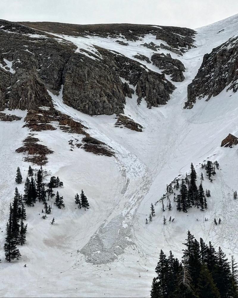
An isolated or MODERATE danger exists for human triggered avalanches involving shallow slabs of wind drifted snow on slopes facing N-NE-E-SE above treeline. Shallow sluffs may also occur in very steep terrain on all aspects.

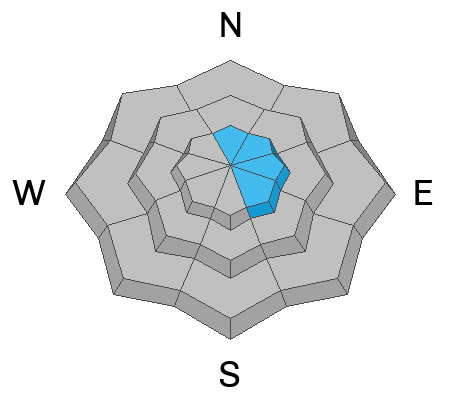
Below treeline, a remote possibility remains for triggering a wet slab avalanche. If the underlying crust is not supportable, and you are punching through into wet snow, that's your cue to avoid steep terrain in these areas.

Cornices are massive, give them a wide berth.
Low
Moderate
Considerable
High
Extreme
Learn how to read the forecast here
Special Announcements
Sunday will be our last regularly scheduled daily forecast.
Geyser Pass Road: The road is mostly dry dirt with a few muddy patches.
Grooming: Gavin may get up today for one more round of grooming to set things up for the weekend.
Weather and Snow
6:00 a.m. Snow and Weather Data
24 Hour Snow 4" 72 Hour Snow 4" Season Total Snow 319" Base Depth at Gold Basin 94"
Temp 29°F Winds on Pre-Laurel Peak: SW 15-20 G 28

Weather
A low pressure system is currently working its way through Eastern Utah and into Western Colorado. Snowfall began around midnight which coincided with a slight decrease in winds. Snow showers should continue through the morning with another 2"- 4" possible. Winds will shift to more westerly blowing in the 10-20 mph range, and high temps at 10,000' will be near 30°F. Skies will begin to clear tonight as the storm moves on. Temps will plummet to near 10°F and winds will shift to the NW. The weekend looks sunny and nice with high temps in the mid 30's on Saturday, and getting up into the mid 40's on Sunday.

General Conditions
It won't be deep powder skiing out there today, but the the new snow will help freshen up the old surface. At mid and upper elevations you will definitely feel the hard, old snow surface, courtesy of last night's freeze. At lower elevations, the freeze wasn't as solid, and the new snow may actually insulate the old wet snow surface further reducing the quality of the freeze. In these areas, a remote possibility remains for triggering a wet slab avalanche. Be mindful of steep, lower elevation terrain if you are punching through the crust into wet snow. New snow avalanche problems should be mostly minimal, but be on the lookout for shallow wind drifts on upper elevation, north through southeasterly aspects. There may also be some shallow, loose snow sluffing off the hard surface on very steep slopes on all aspects. Corn snow conditions are officially on hold.
Snowpack and Weather Data
Gold Basin Storm Stake (10,000')
Gold Basin SNOTEL site (10,000')
SNOTEL site near Geyser Pass Winter Trailhead (9600')
Wind Station on Pre-Laurel Peak (11,400')
NWS forecast for the La Sal Mountains.
Recent Avalanches
Mark White sent in this photo of a loose wet avalanche in Talking Mountain Cirque that likely ran on Wednesday afternoon. He noticed a couple others as well.
See the La Sal avalanche database here.
Ad
Avalanche Problem #1
Wind Drifted Snow
Type
Location
Likelihood
Size
Description
Be on the lookout for shallow, fresh deposits of wind drifted snow on steep slopes above treeline that face primarily north through southeast. Even a small triggered wind slab could carry you over a cliff, or take you for a long ride in areas of more extreme terrain.
Avalanche Problem #2
Wet Snow
Type
Location
Likelihood
Size
Description
Overnight freezing temperatures have largely put a lid on wet avalanche activity. That said, we just went about four days without a freeze, and low elevation temperatures only dipped below freezing for a few hours last night. Additionally, the new snow can actually insulate the old wet snow, keeping the heat in. In these areas, the possibility exists for triggering a wet slab avalanche. If the underlying crust is not supportable, and you are punching through into wet snow, that's your cue to avoid steep terrain in these areas.
Additional Information
The window for skiing the north side of Mount Tukuhnikivatz or "Tuk" (pronounced tuque, like the hat) in dry, stable snow was short this year but people sure took advantage of it!
Tim Mathews photo.
General Announcements
This forecast is from the U.S.D.A. Forest Service, which is solely responsible for its content. This forecast describes general avalanche conditions and local variations always occur. This forecast will be updated by 7:30 tomorrow morning.