Forecast for the Moab Area Mountains

Dave Garcia
Issued by Dave Garcia for
Wednesday, April 10, 2024
The avalanche danger is generally LOW. Small avalanches remain possible on isolated terrain features or in areas of extreme terrain. Be on the lookout for stiff, shallow deposits of wind drifted snow.
There are some slick, hard surfaces out there and slide for life conditions may exist. Stay situationally aware and consider carrying tools for self arrest if venturing into larger, steeper terrain.
As temperatures increase throughout the week, so will the likelihood for loose wet activity.
Low
Moderate
Considerable
High
Extreme
Learn how to read the forecast here
Special Announcements
Road Conditions: The Geyser Pass road is melted out down to the dirt.
Grooming: Grooming is done for the season.
Weather and Snow
6:00 a.m. Snow and Weather Data
24 Hour Snow 0" 72 Hour Snow 0" Season Total Snow 192" Depth at Gold Basin 59"
Winds on Pre-Laurel Peak: NNW 16 - 20 Temp 24° F Percent of Normal: 140%

Weather
A weak shortwave over the Northern plains will keep temperatures cool over our region, and highs should be similar to yesterday, around 33 degrees. We will see sunny skies and NW winds blowing 15-20 MPH. Tomorrow the ridge of high pressure builds in from the West, allowing temperatures to warm up by 5-10 degrees. The winds should back off a bit tomorrow before they start to ramp up again on Friday and the weekend. We will see continued sunshine, highs in the low 40's, and breezy conditions through Sunday.
General Conditions
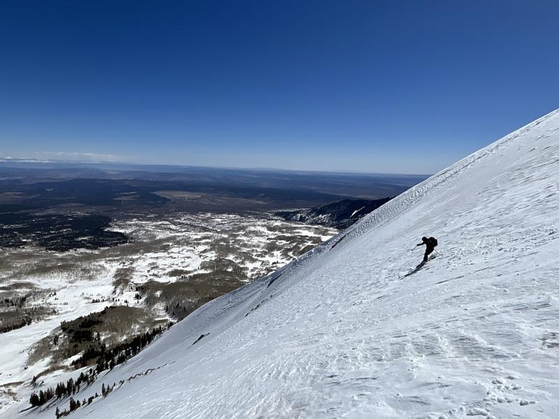
The strong April sun is doing its thing, and conditions are starting to improve out there. I spoke with one party yesterday that reported soft, spring-like conditions on South and West aspects and dry winter-like snow on a due East aspect. Nate and I checked out upper elevation SE and it wasn't quite corn, but it's on the way. The mountains got a solid overnight refreeze and solar aspects will be firm early this morning. If you are corn hunting, South and West aspects will be your best bet today. I think by tomorrow we could see some legit corn skiing. Solar aspects offer the best chance for fun spring skiing, and during April you should always have wet avalanche activity on your mind. If these slopes start to become wet and saturated, it's time to change aspects or head home.
Not quite corn. This SE-facing slope above the tree line hasn't fully transitioned to spring skiing yet. Nate Ament makes the best of it. West and South will be your best bet for soft turns today.
Conditions on Mount Tukuhnikivatz or Tuk (pronounced touque). Many folks this time of year set their sites on this iconic mountain. If you are set on going up, be prepared for challenging conditions including firm snow, breakable crusts, and possibly some isolated, shallow, stiff wind slabs. Ski crampons will be helpful on the skin up, and carrying a tool for self arrest is recommended.
Snowpack and Weather Data
Gold Basin Storm Stake (10,000')
Gold Basin SNOTEL site (10,000')
SNOTEL site near Geyser Pass Winter Trailhead (9600')
Wind Station on Pre-Laurel Peak (11,400')
NWS forecast for the La Sal Mountains.
Recent Avalanches
Click here to see the La Sal avalanche database. Prudent backcountry travelers will want to know what slopes have previously avalanched, as some of these slopes hold shallow, weak snow.
Ad
Avalanche Problem #1
Normal Caution
Type
Location
Likelihood
Size
Description
Most terrain has LOW danger. LOW doesn't mean NO however. Here are a few things to be aware of:
  • It's April, and the best skiing is going to be on solar aspects. This time of year, you should always be considering the potential for avalanches involving wet snow. Be on the lookout for the usual signs of wet activity including pin-wheels, roller balls, saturated snow, and sinking in deep with your skis or boots. If you see these signs, it is time to change aspects.
  • Isolated, shallow stiff slabs of wind drifted snow are lurking about. They aren't going to bury you, but they could be problematic, especially in areas of extreme terrain where a shallow slab release could sweep you off your feet and carry you over a cliff. If you find the snow breaking up into blocks like this, you've found a wind slab. Most are pretty well stuck into place but it's something to keep an eye out for.
  • Slick, hard snow surfaces exist and slides for life are possible. Stay aware of your situation and your exposure. Consider carrying tools for self-arrest if you plan to venture into larger, steeper terrain.
  • Areas with poor snowpack structure, or in other words, weak faceted snow under old wind slabs can still be found out there. More the exception than the rule, you can nevertheless find this structure in repeat running slide paths, along wind swept ridges, and along wind scoured slope margins near rocky outcrops. If you are getting into higher, more extreme terrain, it's worth poking around and looking for this weak structure, and maybe reconsidering your line if you find it.
Additional Information
Want some more insight into the La Sal Mountains as well as the communal impacts of a tragic avalanche? Check out the latest UAC podcast with forecaster Eric Trenbeath where he discusses the range, it's often treacherous snowpack, and how the devastating avalanche in February, 1992, affected the Moab community.
Our avalanche beacon checker sign and beacon training park are up and running. A huge thanks to Talking Mountain Yurts for sponsoring those this season!
Sign up for forecast region-specific text message alerts. You will receive messages about changing avalanche conditions, watches, warnings and road plowing closures.
Follow us on Instagram @utavy_moab
General Announcements
This forecast is from the U.S.D.A. Forest Service, which is solely responsible for its content. This forecast describes general avalanche conditions and local variations always occur.