Forecast for the Moab Area Mountains

Mark Staples
Issued by Mark Staples for
Saturday, March 9, 2024
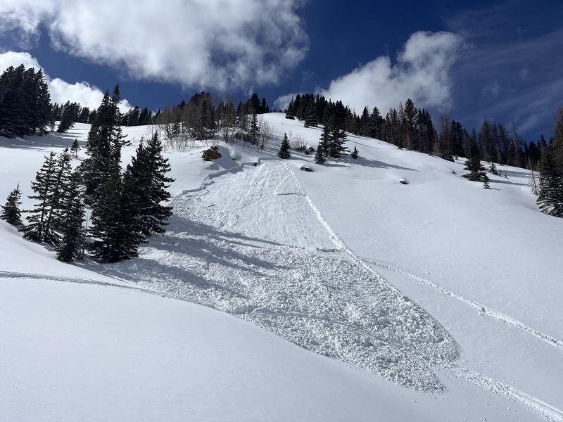
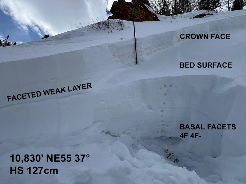
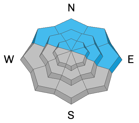
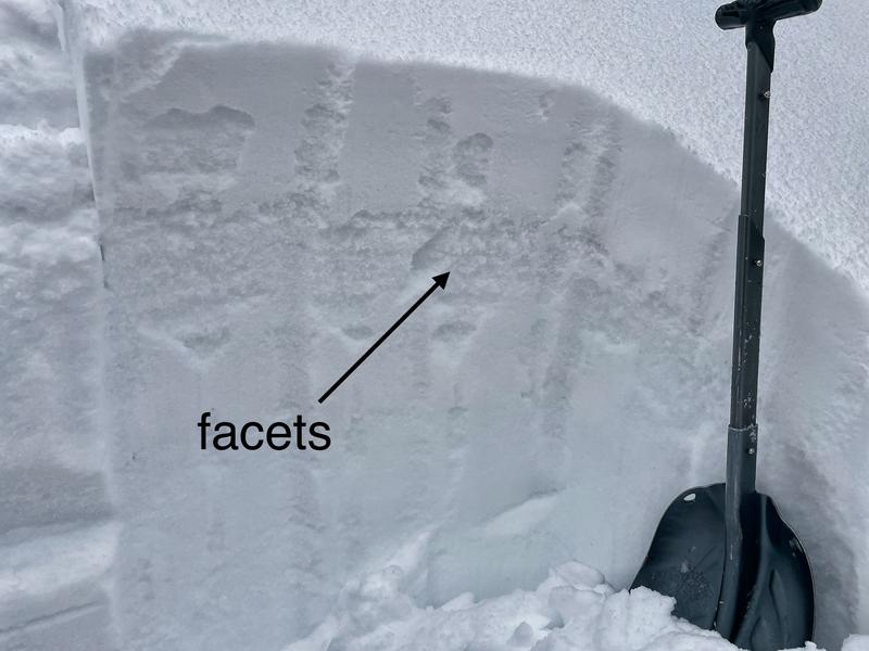
Today the main concern are slopes near and above treeline facing NW, N, NE, & E where winds drifted just enough snow to make a weak layer near the top of the snowpack able to produce soft slab avalanches about a foot deep. Look for subtle signs of minor drifting where the avalanche danger is MODERATE.
Low
Moderate
Considerable
High
Extreme
Learn how to read the forecast here
Special Announcements
We are seeking a passionate individual to join us as Executive Director of the nonprofit Utah Avalanche Center. Click here for more information.
Road Conditions: The Geyser Pass Road to the winter trailhead is plowed with a mix of dirt and mud and snow.
Grooming: Trails were supposedly groomed yesterday.
Weather and Snow
6:00 a.m. Snow and Weather Data
24 Hour Snow 0" 72 Hour Snow 3" Season Total Snow 146" Depth at Gold Basin 54"
Winds on Pre-Laurel Peak: E 12 mph Temp 11° Percent of Normal: 96%

Weather
There may be a few low clouds lingering this morning, but it will be a clear, sunny day with light winds swirling from a few different directions. With a cool airmass overhead, today's strong sunshine will raise temperatures at 10,000' to near 30 degrees F. Sunday appears to be more of the same with slightly warmer temperatures. The weather becomes a little more interesting at the start of the week, and the best chance for snow will be late Tuesday into Wednesday when a storm tracks across the Utah/Arizona border.
General Conditions
It's amazing how just a few inches of new snow really improves conditions and the skiing yesterday on northerly facing terrain was fantastic. Despite afternoon clouds and flurries, it doesn't take much sunshine this time of year to turn the snow wet on sunny aspects which had a pretty stout crust under the new snow.
This season has been plagued by old snow from November and December that formed a persistent weak layer near the bottom of the snowpack. Most avalanche activity on this PWL was just over a month ago in the first week of February. Since then over the last month, the total water weight added to the snowpack from snowfall has been just over 2" of SWE over about 5 storms combined with a major wind event last weekend. Eric wrote a recent blog about this PWL, and now it seems to be mostly dormant.
The weakest layer in the snowpack that caught my attention in Corkscrew Glades is a layer of obvious facets near the surface that Dave and I easily found yesterday. We suspect it formed after last weekend's wind event and may be on most northerly facing slopes now capped by recent snow. A similar layer (or maybe the same layer) caused a slide on Wednesday, see below.
Snowpack and Weather Data
Gold Basin Storm Stake (10,000')
Gold Basin SNOTEL site (10,000')
SNOTEL site near Geyser Pass Winter Trailhead (9600')
Wind Station on Pre-Laurel Peak (11,400')
NWS forecast for the La Sal Mountains.
Recent Avalanches
Eric discovered this slide on Wednesday triggered by a snowbike which highlights a weak layer near the top of the snowpack near Colorado Bowl on the east side of Geyser Pass (NE, 10,800') . This slope had a soft slab of wind drifted snow on top of a faceted layer.
Ad
Avalanche Problem #1
Persistent Weak Layer
Type
Location
Likelihood
Size
Description
There are two distinctly different persistent weak layers we're watching. One is the old PWL of November/December snow that last caused avalanches about a month ago. It is dormant for now and could stay that way for the rest of the season.
The second PWL possibly formed early in the week. Dave, Sam, and I easily found it yesterday in Corkscrew glades, but it only has about 6" of snow on top of it and was stubborn in our stability test. However, it did produce one collapse with a shooting crack as we crossed a subtle ridge feature where localized winds had drifted a little bit of snow. We confidently skied steep terrain where the powder was soft and winds had not moved any snow. The slide Eric found on Wednesday shows that we can't let our guard down.
Now it's tricky. With the old PWL near the ground going dormant, I would be stepping out into bigger terrain. However, I'd be checking the top foot of the snowpack looking for this most recently PWL. We suspect that it may exists even in alpine terrain because winds have been mostly light since it formed and was buried. If I were to find this weak layer, I would only be worried about it where winds drifted some snow - which may not be totally obvious.
Additional Information
Want some more insight into the La Sal Mountains as well as the communal impacts of a tragic avalanche? Check out the latest UAC podcast with forecaster Eric Trenbeath where he discusses the range, it's often treacherous snowpack, and how the devastating avalanche in February, 1992, affected the Moab community.
Our avalanche beacon checker sign and beacon training park are up and running. A huge thanks to Talking Mountain Yurts for sponsoring those this season!
Sign up for forecast region-specific text message alerts. You will receive messages about changing avalanche conditions, watches, warnings and road plowing closures.
Follow us on Instagram @utavy_moab
General Announcements
This forecast is from the U.S.D.A. Forest Service, which is solely responsible for its content. This forecast describes general avalanche conditions and local variations always occur.