Forecast for the Moab Area Mountains

Eric Trenbeath
Issued by Eric Trenbeath for
Friday, March 8, 2024
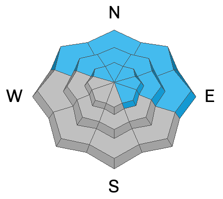
The avalanche danger is MODERATE. You may still be able to trigger an avalanche 1'-2' deep where slabs of wind drifted snow exist over weak layers high up in the snowpack, primarily on slopes facing NW-N-NE-E.
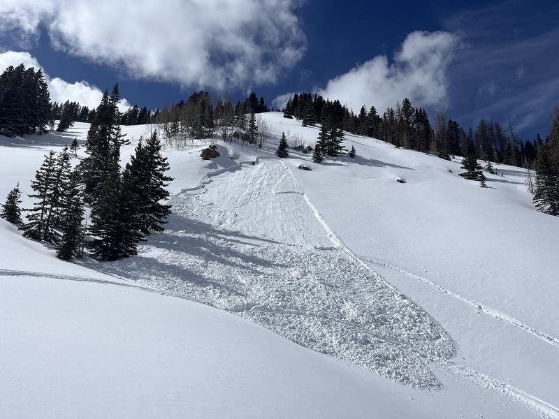
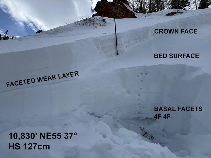
In these same areas, there remains a low likelihood - high consequence scenario for human triggered avalanches failing on a persistent weak layer at the base of the snowpack. Minimize your risk by avoiding steep, rocky, thinner snowpack areas and slopes with complex terrain features.
Low
Moderate
Considerable
High
Extreme
Learn how to read the forecast here
Special Announcements
We are seeking a passionate individual to join us as Executive Director of the nonprofit Utah Avalanche Center. Click here for more information.
Road Conditions: The Geyser Pass Road to the winter trailhead is plowed. The surface is a mix of dirt and mud and sections of packed snow.
Grooming: Trails will be covered in a few inches of fresh snow this morning. LUNA has plans to groom later today.
Weather and Snow
6:00 a.m. Snow and Weather Data
24 Hour Snow 3" 72 Hour Snow 3" Season Total Snow 146" Depth at Gold Basin 54"
Winds on Pre-Laurel Peak: N 5-10 Temp 16° Percent of Normal: 96%

Weather
We should see a little bit of everything today. Look for lingering clouds this morning as the southern trough tracks eastward. Skies should clear and become mostly sunny by mid-morning. By afternoon, a weak shortwave dropping down from the northwest should bring more clouds, winds from the north increasing to 15-20 mph, and a slight chance for some flurries. High temps at 10,000' will be in the upper 20's. The weekend looks dry and sunny with a return to an unsettled pattern next week.
General Conditions
We've had to learn to be happy with a little this season, and 3" of new snow will freshen things up a bit, especially on sheltered, northerly aspects where conditions were already pretty good. Winds over the past few days have been generally calm, and slabs of drifted snow that formed that formed during the Sunday-Monday period are largely stuck in place. The exception will be areas where drifted slabs exist over collapsible weak layers higher up in the snowpack. You are most likely to find this problem on northerly aspects, and the only way to know if a weak layer exists is to dig down a foot or two.
And finally, deep drifts formed over the weekend have added stress to a persistent weak layer (PWL) of faceted snow near the base of the snowpack. We are uncertain to what degree this load has affected the PWL, and we've been wrestling with how to quantify the likelihood of triggering a deep avalanche for some time now. For more details on that see my recent blog post. The bottom line is that Dave and I are continuing to avoid big, steep, northerly facing slopes.
Snowpack and Weather Data
Gold Basin Storm Stake (10,000')
Gold Basin SNOTEL site (10,000')
SNOTEL site near Geyser Pass Winter Trailhead (9600')
Wind Station on Pre-Laurel Peak (11,400')
NWS forecast for the La Sal Mountains.
Recent Avalanches
In our travels on Wednesday, ranger Ben Chicken and I came across this recent moto-triggered avalanche near Colorado Bowl on the east side of Geyser Pass (NE, 10,800'). The culprit was a soft slab of wind drifted snow over top of a faceted weak layer about a foot deep. Although the snowpack was quite thin, the avalanche did not step down to the persistent weak layer at the base of the snowpack. That's the good news. The bad news is, we don't know how widely distributed the weak layer is that it ran on. Not a huge avalanche, it could still certainly boss you around.
Ad
Avalanche Problem #1
Persistent Weak Layer
Type
Location
Likelihood
Size
Description
Slabs of wind drifted snow formed earlier in the week have largely stabilized, but in some cases they are resting on top of faceted weak layers that were buried near the surface as the human triggered avalanche detailed above demonstrates. I don't think this problem is widespread, but the only way to make sure it's not there is to dig down a foot or two and make sure before you commit to a slope.
A lower likelihood, but much higher consequence scenario remains for avalanches failing down to the persistent weak layer (PWL) at the base of the snowpack. Deep wind-drifts have added more stress to this buried weak layer, particularly on northerly aspects right around treeline and above. I have not observed any natural activity as a result of this load, but it may have increased the likelihood for a human trigger. Again, this is a hard call to make. If you chose to venture into this terrain, minimize your risk by avoiding steep, rocky, thinner snowpack areas and slopes with complex terrain features.
Additional Information
Want some more insight into the La Sal Mountains as well as the communal impacts of a tragic avalanche? Check out the latest UAC podcast with forecaster Eric Trenbeath where he discusses the range, it's often treacherous snowpack, and how the devastating avalanche in February, 1992, affected the Moab community.
Our avalanche beacon checker sign and beacon training park are up and running. A huge thanks to Talking Mountain Yurts for sponsoring those this season!
Sign up for forecast region-specific text message alerts. You will receive messages about changing avalanche conditions, watches, warnings and road plowing closures.
Follow us on Instagram @utavy_moab
General Announcements
This forecast is from the U.S.D.A. Forest Service, which is solely responsible for its content. This forecast describes general avalanche conditions and local variations always occur.