UDOT PLANNED AVALANCHE CLOSURES!!

Forecast for the Moab Area Mountains

Eric Trenbeath
Issued by Eric Trenbeath on
Thursday morning, March 6, 2025
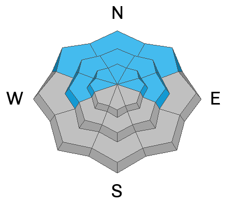
The avalanche danger is MODERATE this morning but will likely reach CONSIDERABLE this afternoon as new and wind drifted snow begin to accumulate. The danger will be greatest on steep, wind drifted slopes facing NW-N-NE-E near and above treeline. In these areas, you are likely to encounter fresh wind slabs and an increased likelihood for dangerous, human triggered avalanches failing on a buried persistent weak layer. This type of terrain should be avoided today.

Once we get more than about 6 inches of snow, expect a MODERATE danger on all other aspects for avalanches involving the recent storm snow. Be alert to changing conditions and look for signs of instability such as cracking in the snow surface. Avoid slopes steeper than 30 degrees if these signs are present.
Low
Moderate
Considerable
High
Extreme
Learn how to read the forecast here
Special Announcements
The La Sal Loop Road will be closed for construction above Pack Creek between 8:30-5:30 today. They aren't currently planning to work on Friday.
The Utah Avalanche Center is excited to host Mountainfilm on Tour in Moab at Star Hall on 3/21 and 3/22. Click here for tickets and information.
We are happy to announce the launch of our new mobile application available on both Android and IOS. Get all the information you need to plan your backcountry adventure and keep the information at the tip of your fingers while you are out. Install the Android version here and the IOS version here.
Geyser Pass Road: Four inches of new snow fell on the Geyser Pass Road on Monday. 4x4 recommended.
Grooming Conditions: Trails have not been recently groomed and have 4 inches of new snow.
Weather and Snow
6 A.M. Snow and Weather Data
24 Hour Snow: 0" 72 Hour Snow: 4" Season Total Snow: 86" Depth at Gold Basin: 39"
Winds on Pre-Laurel Peak: N/A Temp: 31° F Percent of Normal (SWE): 69%
Weather
Pre Laurel Peak wind station and the Gold Basin storm stake are down as we install upgrades including a web cam to the site.
A warm, wet, and windy storm is on our door step. Snow has not yet begun to fall but southerly winds have been cranking up. Today look for periods of heavy snowfall with strong south southwest winds blowing 30-35 mph with gusts as high as 50 mph along ridgetops. Snowfall should kick in late morning with up to 6 inches possible during the day. The storm continues through tomorrow with another 6 inches possible.
General Conditions
It's going to be wild and wooly out there today and it's going to take some time for accumulating snow to improve conditions. The 4 inches that fell on Monday will be the best preserved on sheltered, northerly aspects. As new snow accumulates, these areas will improve the quickest, it's also where you are most likely to find the greatest danger. Most other areas will start out either sun crusted or wind scoured this morning. The snowpack has undergone quite a transition after last week's warm spell with lower elevation slopes having more of a spring-like, isothermal snowpack. Higher up, especially on northerly aspects, the snowpack remains cold, weak, and faceted with a well connected slab on top. I'm uncertain how much the new snow will affect these buried weak layers, so I'm going to adopt a wait and see approach while assuming the likleihood for deep and dangerous avalanches will increase. Be alert to changing conditions. Look for red flag signs of instability such as cracking, collapsing, heavy snowfall, and wind drifted snow, all indicators that it's time to avoid avalanche terrain.
Snowpack and Weather Data
Gold Basin SNOTEL site (10,000')
SNOTEL site near Geyser Pass Winter Trailhead (9600')
Wind Station on Pre-Laurel Peak (11,400')
NWS forecast for the La Sal Mountains.
Recent Avalanches
Ad
Avalanche Problem #1
Persistent Weak Layer
Type
Location
Likelihood
Size
Description
I'm uncertain how the new snow is going to affect our persistent weak layer problem but I'm going to assume it's going to get worse before it gets better. A week of very warm temperatures has helped to strengthen our snowpack, but there is still a possibility for large avalanches failing on faceted layers buried deeply in the pack. The threat is greatest on steep northerly aspects near treeline, but below treeline slopes also have poor snowpack structure. Conservative travelers will continue to avoid slopes steeper than 30 degrees where this structure exists. The incoming storm with heavy snowfall and strong winds will be a good test for these weak layers, and we will be paying close attention to how they respond to the load.
Avalanche Problem #2
Wind Drifted Snow
Type
Location
Likelihood
Size
Description
Heavy snowfall and strong winds will form fresh slabs of wind drifted snow on steep slopes near and above treeline facing NW-N-NE-E. These fresh difts will add more stress to buried persistent weak layers, and this is reason enough to avoid this kind of terrain. Let's see how this new load plays out before we jump into anything.
Avalanche Problem #3
New Snow
Type
Location
Likelihood
Size
Description
We will want to pay attention to how the new snow is behaving today. It is high density and could be inverted on top of colder lower density snow from earlier this week. This can produce an unstable situation. It should be fairly easy to figure out if the new snow is sensitive:
  • Look for any fresh avalanches that have fracture lines about 6 to 10 inches deep.
  • Use small steep test slopes (not large enough to have serious consequences!) to cut across and see if the new snow cracks or moves.
  • Dig quick hand pits and pull on the new snow to see how easy it shears.
It looks like we're going to see a period of stronger wind later this afternoon and this is always a big contributor to unstable conditions. Watch for drifting and avoid the fresh drifts and pillows on steep slopes.
Additional Information
Check out the latest UAC podcast with forecaster Brett "Kowboy" Kobernick where he discusses faceted persistent weak layers and how "nobody is immune from getting killed in an avalanche."
Sign up for text alerts to get the most up to date information about changing conditions, road plowing, special avalanche announcements.
Follow us on Instagram @utavy_moab
General Announcements
This forecast is from the U.S.D.A. Forest Service, which is solely responsible for its content. This forecast describes general avalanche conditions and local variations always occur.