AVALANCHE WARNING!! Tap for info

Forecast for the Moab Area Mountains

Dave Garcia
Issued by Dave Garcia on
Monday morning, March 4, 2024
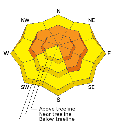
Recent snowfall and strong winds blowing from the WSW have created dangerous avalanche conditions. The danger is CONSIDERABLE, and skiers and riders are LIKELY to trigger avalanches in recent deposits of wind-drifted snow. The danger is most pronounced near treeline and above on slopes that face NW-N-E. Strong winds have reached below treeline, and the remaining slopes have a MODERATE danger. It is POSSIBLE to trigger slabs of wind-drifted snow on all aspects and at all elevations.
Persistent weak layers of faceted snow exist at the base of the pack on slopes that face W-N-E-SE. These layers will be stressed and potentially overloaded by blowing and drifting snow and the danger on these slopes is CONSIDERABLE.
Careful snowpack evaluation, cautious route-finding, and conservative decision-making are essential for backcountry travel today.
Low
Moderate
Considerable
High
Extreme
Learn how to read the forecast here
Special Announcements
We are seeking a passionate individual to join us as Executive Director of the nonprofit Utah Avalanche Center. Click here for more information.
Road Conditions: Geyser Pass Road will close for plowing today. Try to get through the gate by 9 AM if you want to beat the plows. The road is snow-covered, and deep drifts exist in many places.
Grooming: LUNA groomed Gold Basin through Geyser Pass on Friday, expect trails to be snow-covered.
Weather and Snow
6:00 a.m. Snow and Weather Data
24 Hour Snow 0" 72 Hour Snow 8" Season Total Snow 143" Depth at Gold Basin 54"
Winds on Pre-Laurel Peak: SSW 21 G 29 Temp 21° Percent of Normal: 101%

Weather
Today will be cloudy with light snow showers. No additional accumulation is expected. The mercury will hover right around 21 degrees, and it appears we have already hit our high for the day. Winds will continue to blow out of the WSW at 20-30 MPH. Overnight temperatures will drop to 12 degrees, winds will shift to the West and back off to 15-20 MPH. A series of weak waves will move through Tuesday night through Thursday bringing increased cloudiness and very light snow showers to the mountains. I don't see any major producers this week. Sunshine returns this weekend.
General Conditions
Riding conditions were greatly improved on Sunday by the 8 inches of new snow. The new snow is dense, coming in at about 1.0" of SWE, and it has a slight upside down feeling to it. Nevertheless, it produced fun surfy conditions keeping riders on top of the old wind-hammered surface. We found the best skiing and riding in sheltered Northerly facing terrain. Windward slopes are mostly likely scoured by several days of strong SW winds, and you will probably still feel the hard wind crusts on these aspects. Your primary avalanche concern today is wind-drifted snow. Strong winds from the South and West have reached below treeline and fresh drifts of wind-blown snow exist at all elevations. As you gain elevation, slabs of wind-drifted snow will become deeper and more widespread. Northerly aspects near treeline and above will have sensitive slabs of wind-drifted snow up to 18" deep.
The new snow came in with very strong Southerly winds, blowing and drifting snow onto Northerly aspects. These are the exact slopes that continue to harbor deeply buried persistent weak layers of faceted snow. These very strong winds have added a substantial load to these slopes, increasing the odds for triggering a very deep and dangerous avalanche. The best strategy for now is to avoid these slopes, giving them time to adjust to the new load.
Snowpack and Weather Data
Gold Basin Storm Stake (10,000')
Gold Basin SNOTEL site (10,000')
SNOTEL site near Geyser Pass Winter Trailhead (9600')
Wind Station on Pre-Laurel Peak (11,400')
NWS forecast for the La Sal Mountains.
Ad
Avalanche Problem #1
Wind Drifted Snow
Type
Location
Likelihood
Size
Description
Strong winds from the South and West continue to blow and drift snow at all elevations. Skiers and riders will likely trigger avalanches in recently deposited soft and hard slabs of wind-drifted snow. This problem will be most pronounced on leeward-facing slopes near treeline and above where fresh drifts will be 12-18 inches deep. Slopes that face NW-N-E are the bulls-eye location for this problem. Fresh wind slabs will be very sensitive to your weight. Cracking, collapsing, and hollow sounds are obvious clues that you have stepped onto an unstable drift. Hard slabs will be more stubborn to trigger. Hard slabs will allow you to get further out onto them before breaking above you.
It is possible to encounter recent drifts on windward aspects as well. Strong winds often swirl and change direction in the mountains and can deposit snow on any aspect. On slopes that face W-S-SE, this problem will be more isolated. Many Southerly facing slopes may be scoured, but look for fresh drifts around terrain features that facilitate loading such as gully walls, under cliff bands, along sub-ridges, beneath convexities, and in scoops, saddles, and sinks.
Avalanche Problem #2
Persistent Weak Layer
Type
Location
Likelihood
Size
Description
For some time, we have remained in a low likelihood, high consequence scenario for avalanches failing down to the persistent weak layer (PWL). Deep wind-drifts have formed overnight on the same slopes that harbor weak layers of faceted snow, adding stress to the layer and increasing the likelihood of triggering a deep and very dangerous avalanche. Triggering an avalanche in wind-drifted snow remains your primary concern, and any avalanche triggered in wind-drifted snow has the potential to step down to the deeply buried persistent weak layer. The strategy is simple today, to avoid this problem, avoid slopes that harbor this PWL. Give the buried weak layer some time to adjust to the new load Look for safe and fun riding in sheltered, low-angle terrain.
If you have been following our forecast, you have no doubt noticed that we have had a long-lasting persistent weak layer problem. Eric wrote a great blog about this problem, and why it has remained in our forecast for most of the season. It is worth your time to read the blog here.
Additional Information
Want some more insight into the La Sal Mountains as well as the communal impacts of a tragic avalanche? Check out the latest UAC podcast with forecaster Eric Trenbeath where he discusses the range, it's often treacherous snowpack, and how the devastating avalanche in February, 1992, affected the Moab community.
Our avalanche beacon checker sign and beacon training park are up and running. A huge thanks to Talking Mountain Yurts for sponsoring those this season!
Sign up for forecast region-specific text message alerts. You will receive messages about changing avalanche conditions, watches, warnings and road plowing closures.
Follow us on Instagram @utavy_moab
General Announcements
This forecast is from the U.S.D.A. Forest Service, which is solely responsible for its content. This forecast describes general avalanche conditions and local variations always occur.