Forecast for the Moab Area Mountains

Dave Garcia
Issued by Dave Garcia for
Sunday, March 3, 2024
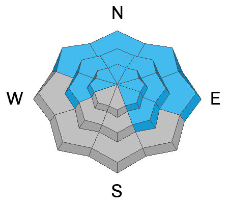
A fast-moving cold front has delivered 8 inches of new snow, strong winds, and an increase in avalanche danger. The danger is CONSIDERABLE. Skiers and riders are LIKELY to trigger avalanches in recent deposits of wind-drifted snow. This problem is most pronounced on leeward slopes that face W-N-E where you can find drifts 12-18 inches deep. Swirling winds deposit fresh drifts around the compass and the remaining slopes have a MODERATE danger. It is POSSIBLE to trigger slabs of wind-drifted snow at all aspects and elevations.
Persistent weak layers of faceted snow exist at the base of the pack on slopes that face W-N-E-SE. These layers will be stressed and potentially overloaded by blowing and drifting snow and the danger on these slopes is CONSIDERABLE.
Careful snowpack evaluation, cautious route-finding, and conservative decision-making are essential for backcountry travel today.
Low
Moderate
Considerable
High
Extreme
Learn how to read the forecast here
Special Announcements
Road Update: A tree has blown across the road above the Trans-La Sal Tailhead and access to the Geyser Pass Winter TH is blocked. Plan at parking at the lower Trans La Sal lot.
We are seeking a passionate individual to join us as Executive Director of the nonprofit Utah Avalanche Center. Click here for more information.
Road Conditions: The Geyser Pass Road is not plowed. AWD with good tires recommended.
Grooming: LUNA groomed Gold Basin through Geyser Pass on Friday, expect trails to be snow covered.
Weather and Snow
6:00 a.m. Snow and Weather Data
24 Hour Snow 8" 72 Hour Snow 8" Season Total Snow 143" Depth at Gold Basin 55"
Winds on Pre-Laurel Peak: WSW 26 G 37 Temp 19° Percent of Normal: 99%

Weather
A cold front pushed its way through our region just before midnight bringing a quick burst of snow and a rapid drop in temperature. Light snowfall will continue in the post-frontal airmass, but I don't see much more accumulation for the La Sals and it should be mostly over by 11 AM. Gusty winds will continue this morning in the 20-30 MPH range out of the SW and should decrease to 10-20 MPH by this evening. High temps will remain right around 20 degrees and will drop to 10 degrees overnight. Monday should be partly sunny with a high of 21 and continued breezy conditions. An unsettled pattern remains through the week bringing more chances for snow.
General Conditions
Yesterday was a rough one out there, as the mountains were completely wind-hammered. 8 inches of new snow will greatly improve skiing and riding conditions. The new snow fell with strong winds out the WSW and is easily blown and drifted into fresh slabs that will be sensitive to the weight of skiers and riders. These slabs could potentially be 12-18" deep on leeward slopes. The widespread formation of wind-drifted snow causes a considerable bump in the avalanche danger. If you have been getting into bigger terrain lately, it is time to reel it back in. Look for the best and safest riding conditions on low-angle sheltered slopes today.
The new snow and widespread blowing and drifting snow will also increase the danger of avalanches failing on the deeply buried early season persistent weak layer. Deep drifts will add stress to this layer increasing the chances of triggering an avalanche. Any avalanche triggered in a slab of wind-drifted snow has the potential to step down to the persistent weak layer, causing a very deep and dangerous avalanche. You can keep it simple today by avoiding slopes that harbor this weak layer giving the snowpack a little time to adjust to this new load.
To read a report of my travels yesterday click here, or check out this video:
Snowpack and Weather Data
Gold Basin Storm Stake (10,000')
Gold Basin SNOTEL site (10,000')
SNOTEL site near Geyser Pass Winter Trailhead (9600')
Wind Station on Pre-Laurel Peak (11,400')
NWS forecast for the La Sal Mountains.
Ad
Avalanche Problem #1
Wind Drifted Snow
Type
Location
Likelihood
Size
Description
Skiers and riders are likely to trigger avalanches in recently deposited slabs of wind-drifted snow. This problem will be most pronounced on leeward-facing slopes near treeline and above where fresh drifts will be 12-18 inches deep, and very sensitive to your weight. Cracking, collapsing, and hollow sounds are red flag signs that you have stepped onto a fresh drift. Slopes that face W-N-E are the bulls-eye location for this problem today, however strong winds often swirl and change direction in the mountains and can deposit snow on any aspect. On slopes that face SW-S-SE this problem will be more isolated. Many Southerly facing slopes may be scoured, but look for fresh drifts around any terrain features that facilitate loading such as gully walls, under cliff bands, along sub-ridges, beneath convexities, and in scoops, saddles, and sinks
Avalanche Problem #2
Persistent Weak Layer
Type
Location
Likelihood
Size
Description
For some time, we have remained in a low likelihood, high consequence scenario for avalanches failing down to the persistent weak layer (PWL). Deep wind-drifts have formed overnight on the same slopes that harbor weak layers of faceted snow, adding stress to the layer and increasing the likelihood of triggering a deep and very dangerous avalanche. Triggering an avalanche in wind-drifted snow remains your primary concern, and any avalanche triggered in wind-drifted snow has the potential to step down to the deeply buried persistent weak layer. The strategy is simple today, to avoid this problem, avoid slopes that harbor this PWL. Look for safe and fun riding in sheltered, low-angle terrain.
If you have been following our forecast, you have no doubt noticed that we have had a long-lasting persistent weak layer problem. Eric wrote a great blog about this problem, and why it has remained in our forecast for most of the season. It is worth your time to read the blog here.
Additional Information
Want some more insight into the La Sal Mountains as well as the communal impacts of a tragic avalanche? Check out the latest UAC podcast with forecaster Eric Trenbeath where he discusses the range, it's often treacherous snowpack, and how the devastating avalanche in February, 1992, affected the Moab community.
Our avalanche beacon checker sign and beacon training park are up and running. A huge thanks to Talking Mountain Yurts for sponsoring those this season!
Sign up for forecast region-specific text message alerts. You will receive messages about changing avalanche conditions, watches, warnings and road plowing closures.
Follow us on Instagram @utavy_moab
General Announcements
This forecast is from the U.S.D.A. Forest Service, which is solely responsible for its content. This forecast describes general avalanche conditions and local variations always occur.