31st Annual Backcountry Benefit - September 12th - Tickets Available Here!

Forecast for the Moab Area Mountains

Eric Trenbeath
Issued by Eric Trenbeath on
Saturday morning, March 30, 2024
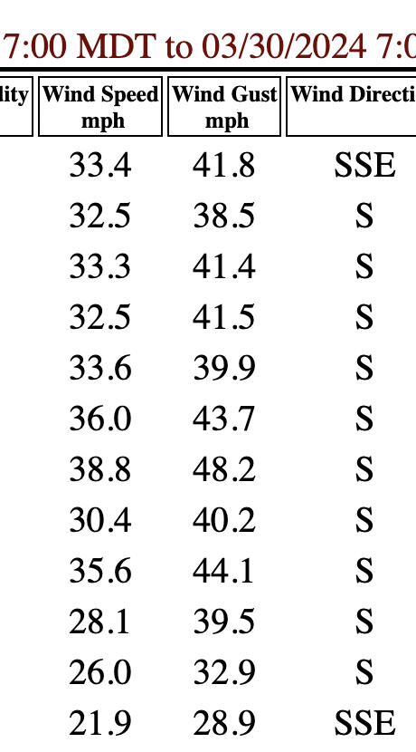
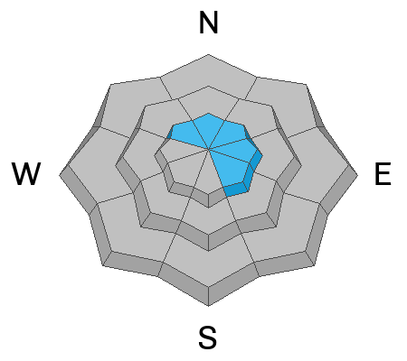
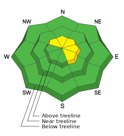
Most terrain has LOW danger. An isolated or MODERATE danger exists for human triggered avalanches involving slabs of wind drifted snow, primarily on steep, upper elevation slopes that face NW-NE-SE. The danger includes both deeper drifts that formed earlier in the week, as well as shallow, recent deposits of wind drifted snow.
Low
Moderate
Considerable
High
Extreme
Learn how to read the forecast here
Special Announcements
Road Conditions: The Geyser Pass Road is plowed and is mostly down to the dirt. It gets muddy and sloppy later in the day.
Grooming: Trails were packed into Gold Basin Wednesday.

Support the UAC website backend platform rebuild to ensure the ongoing security of the website and the data stored on the site rebuild by donating to our spring campaign. Save lives by making a donation today! HERE
Weather and Snow
6:00 a.m. Snow and Weather Data
24 Hour Snow 1" 72 Hour Snow 1" Season Total Snow 183" Depth at Gold Basin 65"
Winds on Pre-Laurel Peak: S 30-40 G 48 Temp 31° F Percent of Normal: 135%

Weather
Same story, different day. Winds from the S continue to crank but with an increase in speed of about 10 mph over yesterday. Today, look for mostly cloudy skies, warm temps climbing into the upper 30's, and strong SSW winds blowing in the 30-40 mph range with gusts to 50 along ridge tops. The low pressure system moving down the Pacific coast is losing strength as it heads toward Baja. We should see some snow start to fall on Sunday morning, but I'm afraid this storm is looking like a blowout with continued strong southerly winds and only a few inches of snow.
General Conditions
Understandably, I haven't received any reports from the backcountry over the past couple of days. I'll be out braving the wind ahead of the "storm" today, but I'm expecting to find some pretty rugged conditions with only the most sheltered northerly aspects holding soft snow. If you get out and about, remain on the lookout for slabs of wind drifted snow, primarily on upper elevation, northerly aspects, but with these wind speeds, you may also find some isolated, shallow slabs down low.
Overnight hourly wind speeds:
Snowpack and Weather Data
Gold Basin Storm Stake (10,000')
Gold Basin SNOTEL site (10,000')
SNOTEL site near Geyser Pass Winter Trailhead (9600')
Wind Station on Pre-Laurel Peak (11,400')
NWS forecast for the La Sal Mountains.
Recent Avalanches
Click here to see the La Sal avalanche database.
Ad
Avalanche Problem #1
Wind Drifted Snow
Type
Location
Likelihood
Size
Description
Slabs of wind drifted snow, both old and new, remain the concern out there. Deeper wind drifts that formed earlier in the week have largely stabilized, but there may be some isolated slabs that remain sensitive to the weight of a skier or rider. Approach steep slopes that have a smooth, rounded, or pillowy appearance with caution, especially in areas of consequential terrain.
With south facing surfaces crusted over, there isn't a lot of snow available for transport, but the strong winds we've seen are capable of eroding these crusts, stripping snow from southerly aspects, and depositing it on to northerly facing slopes. Look for fresh deposits of wind drifted snow on the leeward sides of ridge crests and terrain features such as gully walls and sub-ridges. Stiff slabs may sound or feel hollow underneath, and cracking is a sign of instability.
Additional Information
Want some more insight into the La Sal Mountains as well as the communal impacts of a tragic avalanche? Check out the latest UAC podcast with forecaster Eric Trenbeath where he discusses the range, it's often treacherous snowpack, and how the devastating avalanche in February, 1992, affected the Moab community.
Our avalanche beacon checker sign and beacon training park are up and running. A huge thanks to Talking Mountain Yurts for sponsoring those this season!
Sign up for forecast region-specific text message alerts. You will receive messages about changing avalanche conditions, watches, warnings and road plowing closures.
Follow us on Instagram @utavy_moab
General Announcements
This forecast is from the U.S.D.A. Forest Service, which is solely responsible for its content. This forecast describes general avalanche conditions and local variations always occur.