Forecast for the Moab Area Mountains

Eric Trenbeath
Issued by Eric Trenbeath for
Sunday, March 31, 2024
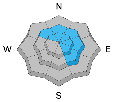
A MODERATE danger exists for human triggered avalanches involving slabs of wind drifted snow, primarily on steep slopes near and above treeline that face NW-NE-SE. Anticipate a rising danger throughout the day if we see accumulating snowfall. Wind slabs may form in unusual places or be located further down slope than you expect. Seek sheltered, low angle terrain for the safest and best skiing and riding today.
Low
Moderate
Considerable
High
Extreme
Learn how to read the forecast here
Special Announcements
Road Conditions: The Geyser Pass Road is plowed and is mostly down to the dirt. It's a little muddy and sloppy with snow on the upper end.
Grooming: All trails were rolled yesterday.

Support the UAC website backend platform rebuild to ensure the ongoing security of the website and the data stored on the site rebuild by donating to our spring campaign. Save lives by making a donation today! HERE
Weather and Snow
6:00 a.m. Snow and Weather Data
24 Hour Snow T" 72 Hour Snow 1" Season Total Snow 183" Depth at Gold Basin 63"
Winds on Pre-Laurel Peak: S 35-40 G 56 Temp 29° F Percent of Normal: 135%

Weather
Trace amounts of snow fell overnight while southerly winds have yet again been on the increase. They'll continue to howl today, blowing in the 30-40 mph range with gusts to 50 along ridge tops. Snowfall should start sometime this morning and continue throughout the day but I'm not expecting much. 3"-5" are possible but it could be a total bust. Winds will finally start to back off tonight. Look for partly sunny skies on Monday with a slight chance for snow showers in the afternoon. High pressure builds mid-week.
General Conditions
In my travels yesterday I was surprised to find how calm it could be in sheltered areas near treeline and below, and there is still some soft snow to be found out there. Winds were definitely blowing and drifting snow however. In spite of the lack of loose snow available for transport, plumes were streaming off the peaks, and N and E facing slopes were being actively loaded. Open slopes near treeline were also getting in on the action and if we pick up any snow today the problem will become more widepread. Exposed terrain has a variety of wind and sun crusts, and you'll want to stick to sheltered, low angle, northerly aspects for the best and safest turning and riding today.
Blustery out there yesterday with active wind loading. Expect more of the same today.
Snowpack and Weather Data
Gold Basin Storm Stake (10,000')
Gold Basin SNOTEL site (10,000')
SNOTEL site near Geyser Pass Winter Trailhead (9600')
Wind Station on Pre-Laurel Peak (11,400')
NWS forecast for the La Sal Mountains.
Recent Avalanches
Click here to see the La Sal avalanche database.
Ad
Avalanche Problem #1
Wind Drifted Snow
Type
Location
Likelihood
Size
Description
Slabs of wind drifted snow have been continuously building over the last several days. Approach steep slopes that have a smooth, rounded, or pillowy appearance with caution, especially in areas of consequential terrain.
With south facing surfaces crusted over, there hasn't been a lot of snow available for transport, but the strong winds we've seen have been eroding these crusts, stripping snow from south and westerly aspects, and depositing it on to northerly facing slopes. Look for fresh deposits of wind drifted snow on the leeward sides of ridge crests and terrain features such as gully walls and sub-ridges. Stiff slabs may sound or feel hollow underneath, and cracking is a sign of instability.
Note the scoured, windward facing, westerly aspect on the shoulder of Mount Mellenthin. The leeward slope opposite to the left is wind loaded. You can also see plumes of blowing snow off the summit of Mount Tukuhniklivatz in the distance.
Additional Information
Want some more insight into the La Sal Mountains as well as the communal impacts of a tragic avalanche? Check out the latest UAC podcast with forecaster Eric Trenbeath where he discusses the range, it's often treacherous snowpack, and how the devastating avalanche in February, 1992, affected the Moab community.
Our avalanche beacon checker sign and beacon training park are up and running. A huge thanks to Talking Mountain Yurts for sponsoring those this season!
Sign up for forecast region-specific text message alerts. You will receive messages about changing avalanche conditions, watches, warnings and road plowing closures.
Follow us on Instagram @utavy_moab
General Announcements
This forecast is from the U.S.D.A. Forest Service, which is solely responsible for its content. This forecast describes general avalanche conditions and local variations always occur.