Forecast for the Moab Area Mountains

Eric Trenbeath
Issued by Eric Trenbeath for
Monday, April 1, 2024
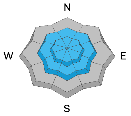
The avalanche danger is CONSIDERABLE on steep, wind loaded, upper elevation NW-N-NE-E aspects. Human triggered avalanches 12"-18" deep are likely in these areas.
The avalanche danger is MODERATE on all other aspects near treeline and above with the greatest danger continuing to be concentrated on northerly facing slopes. On slopes facing the south side of the compass, the danger is not as widespread. In these areas, isolated wind drifts exist next to scoured surfaces, with terrain features making all the difference.
Travel advice for the day: avoid steep slopes on the north side of the compass, especially above treeline. On all other aspects, avoid steep slopes that have recent deposits of wind drifted snow. The safest, and best turning and riding will be found on sheltered, low angle, northerly aspects.
Low
Moderate
Considerable
High
Extreme
Learn how to read the forecast here
Special Announcements
Road Conditions: A few inches of new snow has fallen on the upper end of the Geyser Pass road with some minor drifting. Most vehicles with AWD should make it okay.
Grooming: Trails are covered in fresh snow.

Support the UAC website backend platform rebuild to ensure the ongoing security of the website and the data stored on the site rebuild by donating to our spring campaign. Save lives by making a donation today! HERE
Weather and Snow
6:00 a.m. Snow and Weather Data
24 Hour Snow 7" 72 Hour Snow 8" Season Total Snow 190" Depth at Gold Basin 66"
Winds on Pre-Laurel Peak: SW 15-20 Temp 22° F Percent of Normal: 134%

Weather
Unsettled weather remains over the region today as the southern low pressure system responsible for yesterday's snowfall begins to slowly move eastward from Southern California. Today we should see partly sunny skies with a slight chance for afternoon snow showers. SW winds will average 15-20 mph along ridge tops and high temps at 10,000' will be near 30 degrees. By tonight, winds shift to the NW bumping up into the 20-25 mph range. Tuesday should be sunny with continued breezy NW winds. High pressure lasts through Thursday with another storm lining up for next weekend.
General Conditions
It pays to be pessimistic! Yesterday's snow totals exceeded my expectations with rates of an inch an hour or more between 9:00 a.m. and 2:00 p.m. Needless to say, I got caught with my pants down on yesterday's forecast prompting me to send out a text alert for CONSIDERABLE danger around 1:00 p.m. (sign up for text alerts here). 6" of new snow by then, accompanied by strong SW winds, gusting to 60 mph, were blowing and drifting snow above treeline creating dangerous avalanche conditions right before our eyes. We hightailed it into the woods as quickly as possible and found excellent, creamy, turning and riding conditions. Although peak instability occurred during the height of the storm yesterday, slabs of wind drifted snow will remain ripe for human triggers today. With a round of sunny skies, and high pressure coming up, let's let things settle and have a look around before we push into steeper terrain.
Things got downright western up there yesterday!
Snowpack and Weather Data
Gold Basin Storm Stake (10,000')
Gold Basin SNOTEL site (10,000')
SNOTEL site near Geyser Pass Winter Trailhead (9600')
Wind Station on Pre-Laurel Peak (11,400')
NWS forecast for the La Sal Mountains.
Recent Avalanches
Click here to see the La Sal avalanche database.
Ad
Avalanche Problem #1
Wind Drifted Snow
Type
Location
Likelihood
Size
Description
Strong SW winds blew and drifted snow with a vengeance yesterday. Slabs of wind drifted snow 1'-2' deep are the most widespread on slopes facing NW-N-NE-E above treeline, and these slopes should unequivocally be avoided today. With the strength of the winds, slabs have also developed far down slope, and it's splitting hairs trying to determine where " near treeline" ends and "above treeline" begins. Personally, I'd avoid all steep, mid and upper elevation, northerly facing slopes today. On all other aspects, remain on the lookout for recent deposits of wind drifted snow where terrain features can make all the difference. Look for fresh deposits on the leeward sides of gully walls, sub-ridges, and rocky outcrops. Look for signs of instability such as cracking in the snow surface and avoid steep slopes with recent deposits of wind drifted snow.
Additional Information
Want some more insight into the La Sal Mountains as well as the communal impacts of a tragic avalanche? Check out the latest UAC podcast with forecaster Eric Trenbeath where he discusses the range, it's often treacherous snowpack, and how the devastating avalanche in February, 1992, affected the Moab community.
Our avalanche beacon checker sign and beacon training park are up and running. A huge thanks to Talking Mountain Yurts for sponsoring those this season!
Sign up for forecast region-specific text message alerts. You will receive messages about changing avalanche conditions, watches, warnings and road plowing closures.
Follow us on Instagram @utavy_moab
General Announcements
This forecast is from the U.S.D.A. Forest Service, which is solely responsible for its content. This forecast describes general avalanche conditions and local variations always occur.