Donate to Our Spring Campaign or Bid on our Spring Auction to Support Forecasting

Forecast for the Moab Area Mountains

Eric Trenbeath
Issued by Eric Trenbeath on
Monday morning, March 24, 2025
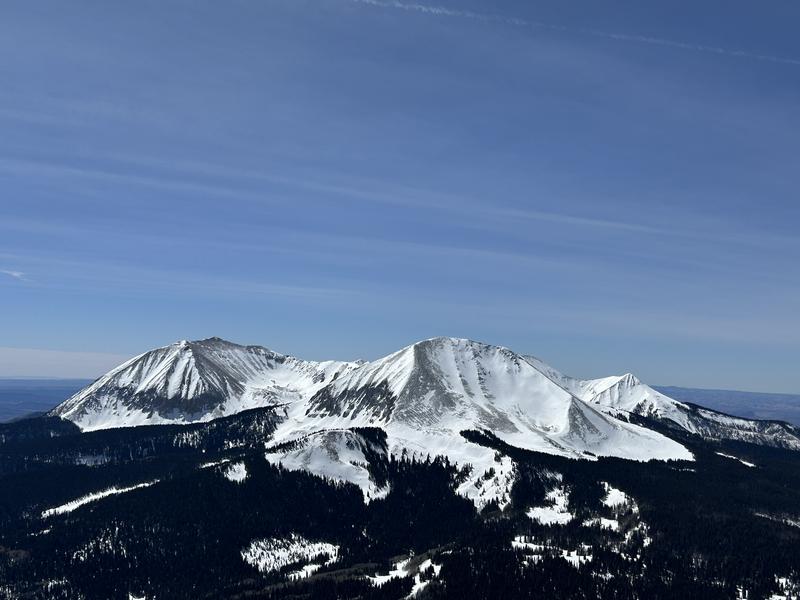
The danger is MODERATE on steep slopes facing W-N-E near and above treeline, and on northerly aspects below. In these areas deep and dangerous, human triggered avalanches failing on a buried persistent weak layer are possible. The danger is greatest on steep slopes near treeline that face N-NE.
As the day heats up the danger will rise to MODERATE for loose wet avalanches on sun exposed slopes. Signs of instability include rollerballs, pinwheels, and sloppy wet snow. Stay off of and out from under steep slopes when these signs are present.
Isolated slabs of wind drifted snow that may be sensitive to a skier or rider still exist above treeline. Avoid steep slopes that have smooth, rounded deposits of wind drifted snow.
Low
Moderate
Considerable
High
Extreme
Learn how to read the forecast here
Special Announcements
Our Spring Campaign is in full swing, and there are two great ways to support forecasting, awareness, and education across Utah: Donate to our Spring Campaign, or Bid on items in our Spring Auction. Every dollar donated helps keep the backcountry community on top.
Construction will resume on the Loop Road today. It will be closed near Pack Creek from 8:30-5:30.
Geyser Pass Road: The road is plowed and is melting out down to the dirt.
Grooming Conditions: Trails were last groomed on Thursday.
Weather and Snow
6 A.M. Snow and Weather Data
24 Hour Snow: 0" 72 Hour Snow: 0" Season Total Snow: 121" Depth at Gold Basin: 49"
Winds on Pre-Laurel Peak: NW 15-18 G 20 Temp: 25° F
Weather
High pressure will dominate the upcoming week with progressively warmer temperatures each day. Today look for sunny skies, light to moderate northwest winds, and high temperatures in the mid to upper 40's at 10,000'. Tuesday through Thursday temperatures rise into the mid 50's. We should see freezing temperatures tonight but it looks marginal after that. A minor storm system should cool things down a little by the weekend.
General Conditions
Spring conditions are in full effect with a mixed bag of sun and wind affected surfaces, and areas of soft, settled powder on sheltered northerly aspects. Corn conditions have not fully developed on sunny slopes but should soon if we get clear skies and at least near freezing temperatures overnight. Dave Garcia and Chris Benson were both up yesterday sampling conditions on south aspects. See their observations here. Dave was over on Mount Tomasaki while Chris made the season's first known ascent of Mount Tukuhinikivatz via the south side from La Sal Pass. North side access to Tuk remains inadvisable due to the continued potential for avalanches. Persistent weak layers of faceted snow remain a problem on slopes facing W-N-E. The most dangerous areas are on steep northerly aspects where wind drifted snow has added stress to these buried weak layers. On these slopes, triggered wind slabs have the potential to step down deeper into the snowpack causing larger and more dangerous avalanches.
High peaks and north faces of the middle group. From left to right: Mounts Peale, Mellenthin, Tukuhinikivatz, Tukno. Dave Garcia photo.
Snowpack and Weather Data
Gold Basin SNOTEL site (10,000')
SNOTEL site near Geyser Pass Winter Trailhead (9600')
Wind Station on Pre-Laurel Peak (11,400')
NWS forecast for the La Sal Mountains.
Recent Avalanches
Riders over on the Manti Skyline are having close calls with deep avalanches and full burials. They have a similar snowpack and it's a strong reminder of what can happen.
See the complete avalanche database here.
Ad
Avalanche Problem #1
Persistent Weak Layer
Type
Location
Likelihood
Size
Description
If you've been following along, you're tired of hearing about persistent weak layers of faceted snow. So are we. This is the time of year when we are usually able to put this problem to bed but with such a dry season prior to Valentine's Day, the entire snowpack had become loose, weak, and faceted, especially near treeline and below on W-N-E aspects. Since February 14, several storms have built a well connected cohesive slab 2-3 feet thick on top of these faceted weak layers. These layers are very slow to heal but the likelihood of triggering an avalanche is decreasing. This is largely due to the strength of the over-riding slab, and how deeply buried the weak layers are. Shallower snowpack areas are the most dangerous, and likely trigger points are steep convexities, shallow rocky areas, and thin slab margins.
Dave dug a pit on a north aspect below treeline yesterday and found a similar structure to what I found last week. In the photos below you can clearly see the weak, faceted snow underneath the over-riding slab. For the first time since Valentine's Day my extended column test produced no results, or ECTX. This indicates that avalanches are becoming more difficult to trigger but this is just one sample in one location. Knowing what's underneath, it's still a gamble, and I'm going to continue to hold my cards close.
The above photo illustrates a dense 4-1 finger hard slab over top of a fist hard, weak layer. The entire snowpack from the fist layer down is faceted. It's not a good looking set up.
For the first time since Valentine's Day, an extended column test produced no results (ECTX).
Avalanche Problem #2
Wet Snow
Type
Location
Likelihood
Size
Description
As the day heats up expect a rising danger for loose wet avalanches. The danger follows the sun with east facing slopes heating up first, then south, and then west. Signs of instability include rollerballs, pinwheels, and sloppy wet snow. Stay off of, and out from under steep slopes when these signs are present.
Additional Information
Check out the latest UAC podcast with forecaster Brett "Kowboy" Kobernick where he discusses faceted persistent weak layers and how "nobody is immune from getting killed in an avalanche."
Sign up for text alerts to get the most up to date information about changing conditions, road plowing, special avalanche announcements.
Follow us on Instagram @utavy_moab
General Announcements
This forecast is from the U.S.D.A. Forest Service, which is solely responsible for its content. This forecast describes general avalanche conditions and local variations always occur.