Forecast for the Moab Area Mountains

Eric Trenbeath
Issued by Eric Trenbeath for
Thursday, March 24, 2022
Heads up, a dramatic warming event is on tap for the next few days creating the potential for increasingly reactive avalanche conditions!
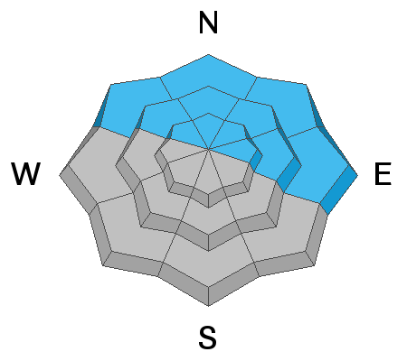
A MODERATE danger remains for human triggered avalanches failing on a buried persistent weak layer on slopes steeper than 30 degrees that face NW-N-NE-E. Avalanches failing on this layer will be 2'-3' deep, and warming temperatures over the next few days may increase the likelihood. Continue to temper your ambitions for steep, northerly facing terrain.
With a strong sun and warming temperatures we'll see a MODERATE danger for loose, wet avalanches on sun exposed slopes. Signs of instability include rollerballs, pinwheels, and sloppy wet snow. Get in and out early, and stay off of, and out from under steep slopes when they start to get wet and sloppy.
Low
Moderate
Considerable
High
Extreme
Learn how to read the forecast here
Special Announcements
Please help support avalanche forecasting throughout Utah. Donate to the Spring Campaign to help raise the funds to support the forecasting you rely on.
Road Conditions: The road is a mix of dirt, mud, and patches of packed snow. It gets sloppier as the days warm up. All wheel drive and good tires are recommended.
Grooming: Trails have not been groomed.
Weather and Snow
6:00 a.m. weather data:
24 Hour Snow 0" 72 Hour Snow 0" Base Depth at Gold Basin 58" Wind NW 10-20 Temp 24F
High pressure is building over the region and warm air will begin filtering in from the SW. Today we'll see sunny skies and temperatures rising up into the mid 40's at 10,000'. Temperatures will steadily increase each day with the potential for record breaking heat this weekend. A low pressure system is currently projected to make landfall on the California coast on Monday bringing a chance for snow to our area on Tuesday.
Snowpack
7" of snow fell early in the week, and three days worth of strong, northerly winds formed fresh drifts on all aspects at upper elevations. Most of these wind slabs have gained strength by now, but continue to be wary of steep slopes that have a smooth, rounded appearance or that sound hollow underneath. With the approaching heat wave, we'll be eyeing the snowpack closely to see how it reacts. In addition to the usual concerns for loose, wet instability on sun exposed slopes, this dramatic warming could make human triggered avalanches, 2'-3' deep more likely on northerly aspects where we still have a buried persistent weak layer of loose, faceted snow. Over the long run, the upcoming warm temperatures should help to strengthen the snowpack, but in the short term, this transition could make things more volatile. Continue to keep it dialed back this weekend. Harvest corn on south facing slopes and get in and out of the mountains early.
Chris Benson was out and about yesterday and sent in this observation. Dave Garcia was up looking at conditions on Tuesday. Here is his take on stability and the potential evolution of the persistent weak layer.
Snow and Weather Links
Gold Basin SNOTEL site (10,000')
Storm Totals in Gold Basin
Wind Station on Pre Laurel Peak (11,700')
Recent Avalanches
No recent avalanches have been reported in the La Sal range.
Ad
Avalanche Problem #1
Persistent Weak Layer
Type
Location
Likelihood
Size
Description
A persistent weak layer of loose, sugary faceted snow exists on NW-N-NE-E aspects beneath a slab that is 2'-3' thick. The weakest snow exists on northerly aspects right around treeline and below. Above treeline, weak layer distribution is more variable but the problem has been compounded by recent wind drifted snow. Stability tests show that avalanches are becoming harder to trigger on this weak layer but that could change with dramatically warming temperatures over the next few days. Snow, like people doesn't like rapid change, and it has a tendency to react poorly. The bottom line is that we could see an increased likelihood for human triggered avalanches failing on this weak layer over the next few days.
Avalanche Problem #2
Wet Snow
Type
Location
Likelihood
Size
Description
With a strong sun and dramatically warm temperatures over the next few days we'll need to be alert to signs of wet instability on all sun exposed slopes. Signs of instability include rollerballs, pinwheels, and sloppy wet snow. With good re-freezes overnight, you should be able to find supportable surfaces and corn snow on SE-SW aspects, but it's that time of year when you need to get in and get out early. Stay off of and out from under steep slopes when they start to get wet, sloppy, and unsupportable.
General Announcements
Who's up for some free avalanche training? Get a refresher, become better prepared for an upcoming avalanche class, or just boost your skills. Go to https://learn.kbyg.org/ and scroll down to Step 2 for a series of interactive online avalanche courses produced by the UAC.
This forecast is from the U.S.D.A. Forest Service, which is solely responsible for its content. This forecast describes general avalanche conditions and local variations always occur.