Donate to Our Spring Campaign or Bid on our Spring Auction to Support Forecasting

Forecast for the Moab Area Mountains

Eric Trenbeath
Issued by Eric Trenbeath on
Friday morning, March 21, 2025
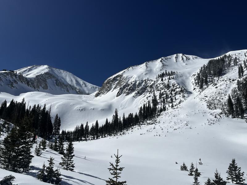
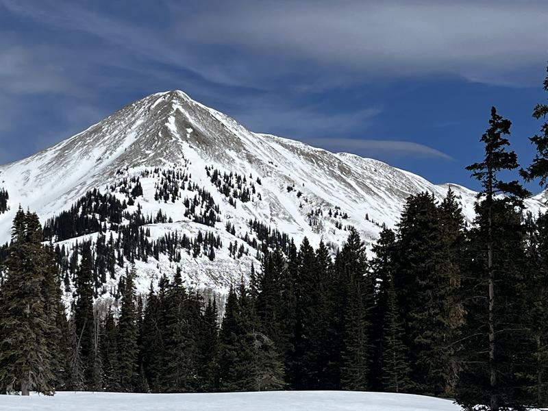
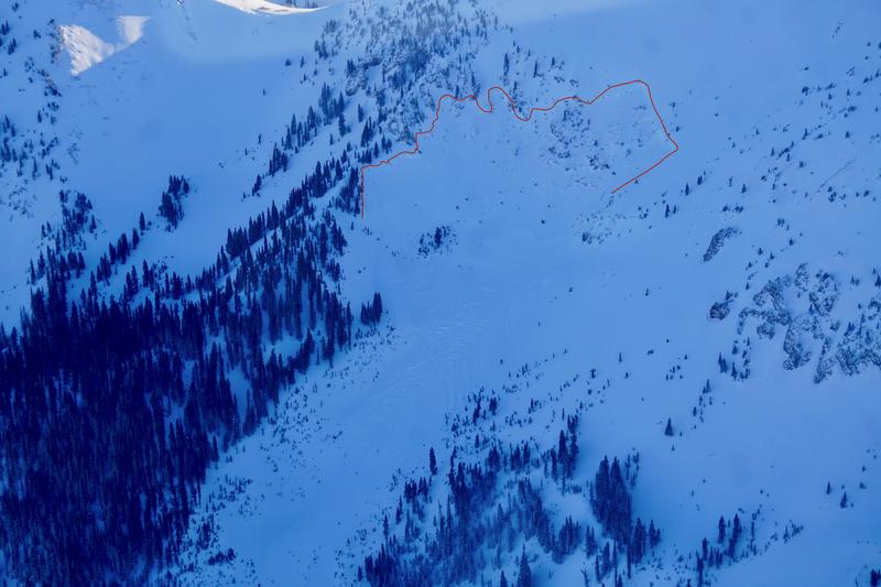
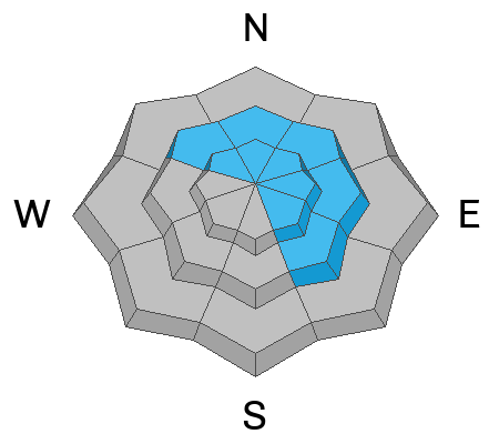
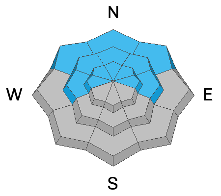
A MODERATE danger exists both for human triggered avalanches involving slabs of wind drifted snow, and for avalanches failing on a buried persistent weak layer. The danger for both problems is greatest on steep slopes near and above treeline that face NW-N-NE-E. In these areas, thick wind slabs formed over the past several days may still be sensitive to the weight of a skier or rider. Drifted snow has also added stress to buried weak layers increasing the likelihood for deeper and more dangerous avalanches. Avoid steep, wind drifted slopes facing the north half of the compass.
Outside of these areas problems are less widespread, however, persistent weak layers remain on west aspects near and above treeline, and on low elevation, northerly aspects. Recent deposits of wind drifted snow may also be found on slopes facing SE. Careful slope evaluation is required for moving into steeper terrain today.
Low
Moderate
Considerable
High
Extreme
Learn how to read the forecast here
Special Announcements
The Utah Avalanche Center is excited to host Mountainfilm on Tour in Moab at Star Hall on 3/21 and 3/22. Click here for tickets and information.
Our Spring Campaign is in full swing, and there are two great ways to support forecasting, awareness, and education across Utah: Donate to our Spring Campaign, or Bid on items in our Spring Auction. Every dollar donated helps keep the backcountry community on top.
Turns out, they are working on the Loop Road today. Closures may be in effect.
Geyser Pass Road: Grand County plowed yesterday.
Grooming Conditions: I packed and groomed all trails from Gold Basin to Geyser Pass yesterday with the roller. Conditions will be good for cross country skiing, but not great for skating. There is no classic track.
Weather and Snow
6 A.M. Snow and Weather Data
24 Hour Snow: 0" 72 Hour Snow: 0" Season Total Snow: 121" Depth at Gold Basin: 53"
Winds on Pre-Laurel Peak: WNW 20-25 G30 Temp: 11° F Percent of Normal (SWE): 119%
Weather
West northwest winds cranked up over the last six hours blowing in the 20-30 mph range on Pre Laurel Peak. Look for increasing clouds today ahead of an approaching system that will largely pass by to the north. We'll see continued moderate westerly winds with stronger gusts along ridge tops. High temperatures at 10,000' will be in the low 30's. Look for a slight chance for isolated snow showers on Saturday morning with mostly cloudy skies and moderate to strong southwest winds during the day. Sunday kicks off a dry and warm period extending through the upcoming week with high temperatures reaching the low 50's by Tuesday. Spring is definitely here.
General Conditions
March has brought the best conditions of the season with over 3 feet of new snow at 4.0 inches of Snow Water Equivalent (SWE). This has made for some great turning and riding but you know what happens when the sun comes out. All sun exposed slopes are crusted over while south and westerly winds over the past few days have also damaged the snow surface. Some south aspects have been scoured right back down to the rocks. In my travels yesterday, however, I continued to find great, soft settled powder on sheltered northerly aspects. Areas with wind drifted snow may remain sensitive to skiers or riders today, and you can still trigger a deep and dangerous avalanche involving persistent weak layers of faceted snow. The bullseye for this problem is on steep northerly aspects right around treeline. Especially in areas where the snowpack remains shallow.
Snow cover in Gold Basin is finally looking pretty good, while many exposed southerly aspects have been stripped back down to the rocks.
Snowpack and Weather Data
Gold Basin SNOTEL site (10,000')
SNOTEL site near Geyser Pass Winter Trailhead (9600')
Wind Station on Pre-Laurel Peak (11,400')
NWS forecast for the La Sal Mountains.
Recent Avalanches
Chis Benson reported this large avalanche in Upper Beaver Basin. A result of the last storm event, this NE facing path avalanched to the ground earlier this season and the snowpack remained shallow and weak in this zone. This type of avalanche remains a concern on steep northerly aspects right around treeline that have a weak and shallow snowpack.
See the complete avalanche database here.
Ad
Avalanche Problem #1
Wind Drifted Snow
Type
Location
Likelihood
Size
Description
Wind slabs old and new remain a concern out there on slopes facing northwest through southeast. Wind slabs are often recognizable by their smooth rounded appearance and they may sound or feel hollow underneath. The deepest drifts are found on northerly aspects above treeline. Older slabs will be stiffer and more stubborn to release today but they could be quite consequential, especially in areas of extreme terrain. Slabs of wind drifted snow also overly buried persistent weak layers, primarily on slopes facing the north side of the compass near and above treeline. In theses areas, a triggered wind slab could step down causing a deeper and much more dangerous avalanche. Avoid steep, wind drifted slopes in these areas.
Avalanche Problem #2
Persistent Weak Layer
Type
Location
Likelihood
Size
Description
March has been a great month for skiing with over three feet of snow and four inches of snow water equivalent (SWE). It is important to realize all of the recent snow has piled up on a snowpack that has remained shallow and weak all season. A thick, cohesive, and well connected slab exists above this weak structure. Each additional load pushes buried weak layers closer to their breaking point. Weak layers are stressed once again by the most recent load, and skiers and riders can trigger deep and dangerous slab avalanches. The most dangerous slopes are steep northerly aspects, especially those that have been recently wind loaded.
Likely trigger points are steep convexities, shallow rocky areas, and thin slab margins. Think about the terrain you are in and what would happen if it slides. You can increase your margin of safety by not skiing above cliff bands or terrain traps, and choosing smooth, planar slopes.
Additional Information
Check out the latest UAC podcast with forecaster Brett "Kowboy" Kobernick where he discusses faceted persistent weak layers and how "nobody is immune from getting killed in an avalanche."
Sign up for text alerts to get the most up to date information about changing conditions, road plowing, special avalanche announcements.
Follow us on Instagram @utavy_moab
General Announcements
This forecast is from the U.S.D.A. Forest Service, which is solely responsible for its content. This forecast describes general avalanche conditions and local variations always occur.