UDOT PLANNED AVALANCHE CLOSURES!!

Forecast for the Moab Area Mountains

Dave Garcia
Issued by Dave Garcia for
Thursday, March 2, 2023
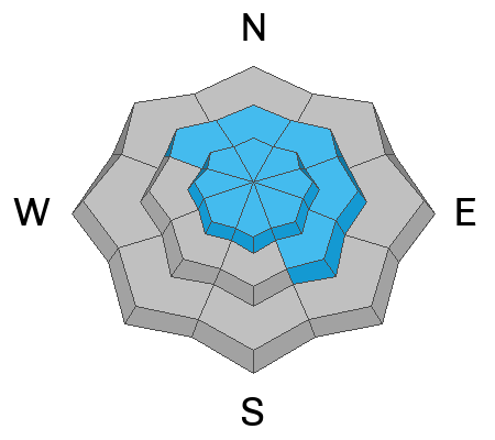
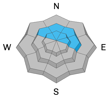
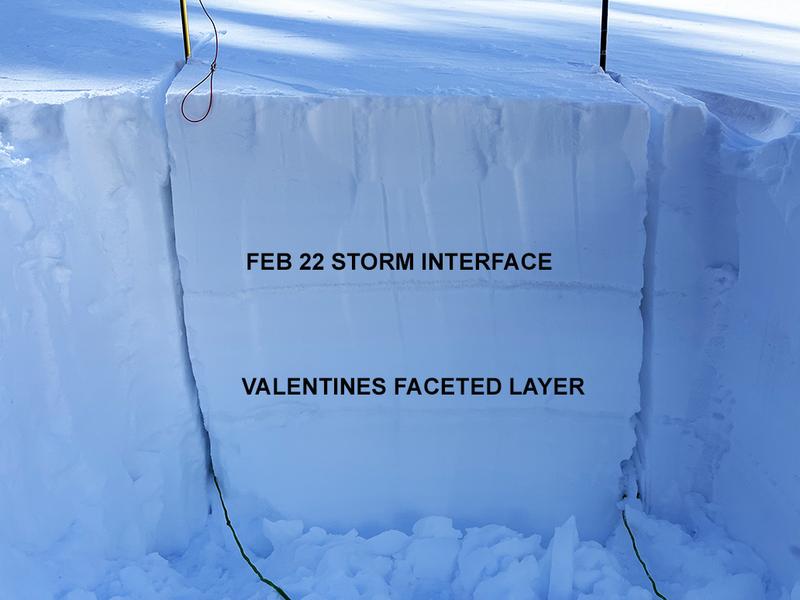
Today the avalanche danger is CONSIDERABLE. Human triggered avalanches are LIKELY on steep slopes with recent deposits of wind drifted snow near treeline and above that face NW-N-NE-E. In some areas, thick slabs of drifted snow exist over buried weak layers where you can trigger a deeper and more dangerous avalanche. Avoid steep, wind loaded, northerly aspects. Shifting winds will create shallow, soft slabs of wind drifted snow on Southerly facing slopes where you will find a MODERATE danger.
Low
Moderate
Considerable
High
Extreme
Learn how to read the forecast here
Special Announcements
Geyser Pass Road: The Geyser Pass Road will be closed this morning for plowing. Expect it to be closed until early afternoon.
Grooming: Trails were last groomed on Saturday and will covered in fresh snow today.
To help you safely enjoy the backcountry, the UAC team is constantly evaluating and implementing new programs and technologies. Donate to the Spring Campaign to help our team implement innovative tools and better provide you with the information you rely on.
Weather and Snow
6:00 a.m. Snow and Weather Data
24 Hour Snow 5" 72 Hour Snow 11" Season Total Snow 229" Base Depth at Gold Basin 90"
Winds on Pre Laurel Peak NW 2 G 5 Temp 3F

Weather
It is a cold morning in Gold Basin as the low exits our area. We can expect sunny skies today with a high around 18 degrees and cold North winds blowing in the 15-20 mph range. We will have cold, breezy, and clear conditions through the weekend.

General Conditions

Skiing conditions should be great today with an 11 inch storm total. Relentless Southerly winds have finally backed off and shifted to the North. You'll want to seek sheltered terrain for the best skiing and riding conditions. Fresh unstable slabs of wind drifted snow exist near treeline and above. Be on the lookout for signs of instability such as cracking in the snow surface. On northerly aspects near and above treeline, thick slabs of drifted snow exist over older, weaker layers. For now, I am avoiding steep Northerly facing slopes until I see how these weak layers react to the recent storm.

Snowpack and Weather Data
Gold Basin Storm Stake (10,000')
Gold Basin SNOTEL site (10,000')
SNOTEL site near Geyser Pass Winter Trailhead (9600')
Wind Station on Pre-Laurel Peak (11,400')
NWS forecast for the La Sal Mountains.
Recent Avalanches
No new avalanches have been reported. See the La Sal Avalanche database here.
Ad
Avalanche Problem #1
Wind Drifted Snow
Type
Location
Likelihood
Size
Description
Blowing and drifting of the new snow has created fresh, unstable slabs of wind drifted snow near treeline and above. The deepest most dangerous drifts will be primarily found above treeline on slopes that face NW-N-NE-E. These drifts will be up to two feet deep and will be sensitive to the weight of a skier or rider. North winds will bump up just enough today that shallow drifts will start forming on Southerly facing slopes as well.
Drifted snow is stiffer and more compacted than non-drifted snow, and hard drifts often produce hollow drum-like sounds when you walk on them. Shooting cracks in drifted snow are a sure sign of instability. Avoid slopes steeper than 30 degrees with recent deposits of wind drifted snow.
Avalanche Problem #2
Persistent Weak Layer
Type
Location
Likelihood
Size
Description
On some northerly aspects, wind drifted snow is sitting on top of buried weak layers. A layer of weak faceted snow formed on the surface early this month and it was covered by a foot of snow on Valentines day. It isn't widespread, and it hasn't proven to be very reactive in stability tests, but it's out there. A weak interface also exists at the bottom of last week's storm snow. The few avalanches that ran on Saturday likely failed on one of these weak layers. The most recent round of fresh wind drifts will add stress to these buried weak layers, steep terrain should be avoided until we see how they react to the new load.
Additional Information
Are you wondering how cell phones and other electronic devices can interfere with your avalanche transceiver? The "20/50 Rule" is that you want your beacon 20cm (8") away from other electronics while transmitting and 50cm (20") away from electronics while searching. Get the full scoop here.
General Announcements
This forecast is from the U.S.D.A. Forest Service, which is solely responsible for its content. This forecast describes general avalanche conditions and local variations always occur. This forecast will be updated by 7:30 tomorrow morning.