Forecast for the Moab Area Mountains

Eric Trenbeath
Issued by Eric Trenbeath for
Wednesday, March 1, 2023
The avalanche danger will be on the rise today. Be alert to changing conditions as new and wind drifted snow accumulate.
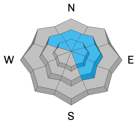
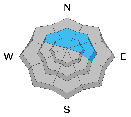
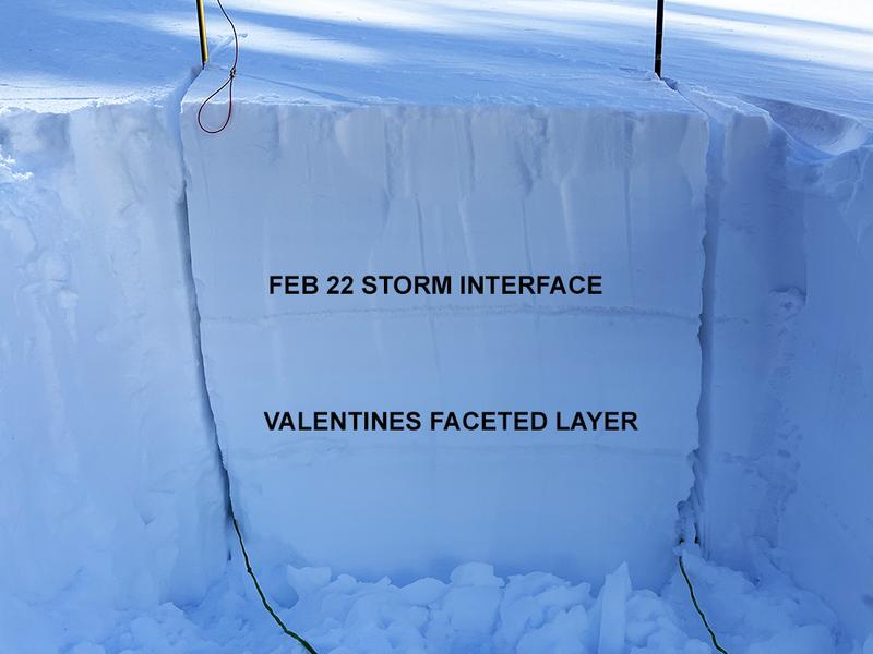
The avalanche danger is CONSIDERABLE on steep slopes above treeline that face NW-N-NE-E and human triggered avalanches involving recent slabs of wind drifted snow are likely. As new snow accumulates, the danger will become more widespread and may also encompass northerly facing terrain near treeline and below. In some areas, thick slabs of drifted snow exist over buried weak layers and avalanches triggered in the new snow could step down causing a deeper and more dangerous avalanche. Avoid steep, wind loaded, northerly aspects.

A MODERATE danger exists for human triggered avalanches involving slabs of new and wind drifted snow on all other aspects near treeline and above. Look for fresh drifts on the leeward sides of terrain features such as gully walls and sub ridges, and look for signs of instability such as cracking in the snow surface.
Low
Moderate
Considerable
High
Extreme
Learn how to read the forecast here
Special Announcements
Geyser Pass Road: Expect to find drifting and accumulating snow over a snowpacked surface. 4x4 and good tires recommended.
Grooming: Trails were last groomed on Saturday and will covered in fresh snow today.
Weather and Snow
6:00 a.m. Snow and Weather Data
24 Hour Snow 6" 72 Hour Snow 6" Season Total Snow 224" Base Depth at Gold Basin 85"
Winds on Pre Laurel Peak SE 15-25 G36 Temp 17F

Weather
A low pressure trough moving into the region is funneling moisture on a southwest flow. Convectively driven precipitation should result in periods of heavy snowfall alternating with dry periods and even brief filtered sunshine. This leaves me somewhat skeptical but we stand to pick up 5"-9" today with snowfall lingering into tonight. SW winds will blow in the 15-25 mph range with gusts to 40. High temps will be in the low 20's. Tonight we'll see decreasing winds shifting to more northerly as the storm moves on. Thursday looks sunny with breezy NE winds and continued cool temps. Look for more of the same through the weekend.

General Conditions
We are getting a nice reset with 6" of new snow overnight and more on the way today. Mercifully, winds won't be too out of hand but they will be blowing and drifting snow, primarily on to northerly aspects. Be on the lookout for fresh, unstable drifts and as new snow piles up and look for signs of instability such as cracking in the snow surface. On northerly aspects near and above treeline, thick slabs of drifted snow exist over older, weaker layers. In these areas, an avalanche triggered in the new snow could step down causing a deeper and more dangerous avalanche. As the new snow adds more weight and stress, let's give "the glue a little time to dry" so to speak before we start venturing back into steep, northerly facing terrain.

Snowpack and Weather Data
Gold Basin Storm Stake (10,000')
Gold Basin SNOTEL site (10,000')
SNOTEL site near Geyser Pass Winter Trailhead (9600')
Wind Station on Pre-Laurel Peak (11,400')
NWS forecast for the La Sal Mountains.
Recent Avalanches
No new avalanches have been reported. See the La Sal Avalanche database here.
Ad
Avalanche Problem #1
Wind Drifted Snow
Type
Location
Likelihood
Size
Description
Blowing and drifting of the new snow will create the greatest hazard today. The deepest and most widespread drifting will occur on slopes facing NW-NE-SE but swirling wind currents could create fresh drifts on all aspects near treeline and above. Look for slabs of wind drifted snow on the leeward sides of terrain features such as sub ridges, gully walls, and rock outcrops. Wind drifts are often recognizable by their smooth, rounded appearance, and they may sound hollow underneath. Avoid slopes steeper than 30 degrees that have fresh deposits of wind drifted snow.
Avalanche Problem #2
New Snow
Type
Location
Likelihood
Size
Description
Soft slab avalanches and loose sluffing will be possible within the new snow today. As new snow piles up pay attention to how it is behaving. Look for signs of instability such as cracking in the snow surface and look for blocks of snow between your skis on the skin track. Suspect slopes steeper than 30 degrees that have more than about 8" of new snow, and avoid them if signs of instability are present.
Avalanche Problem #3
Persistent Weak Layer
Type
Location
Likelihood
Size
Description
On some northerly aspects, wind drifted snow is sitting on top of buried weak layers. A layer of weak faceted snow formed on the surface early this month and it was covered by a foot of snow on Valentines day. It isn't widespread, and it hasn't proven to be very reactive in stability tests, but it's out there. On Saturday, I also observed a weak interface at the bottom of last week's storm snow. The few avalanches we observed Saturday likely failed on one of these weak layers. With more accumulating and wind drifted snow on top of these buried weak layers, let's give it a little time before we step out there.
Additional Information
Are you wondering how cell phones and other electronic devices can interfere with your avalanche transceiver? The "20/50 Rule" is that you want your beacon 20cm (8") away from other electronics while transmitting and 50cm (20") away from electronics while searching. Get the full scoop here.
General Announcements
This forecast is from the U.S.D.A. Forest Service, which is solely responsible for its content. This forecast describes general avalanche conditions and local variations always occur. This forecast will be updated by 7:30 tomorrow morning.