Join us at our 2nd Annual Blizzard Ball

Forecast for the Moab Area Mountains

Issued by Chris Benson on
Tuesday morning, March 2, 2021
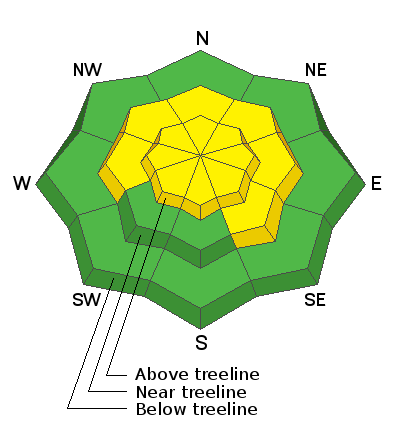
The avalanche danger is MODERATE with recent deposits of wind drifted snow on all aspects above treeline. The primary concern, however, remains the very real possibility of triggering deep and dangerous avalanches failing on a buried persistent weak layer. You are most likely to trigger one of these avalanches on steep terrain near and above treeline that faces W through N, to SE. Avoid areas with thin snow such as rock outcroppings, sparse trees, or along slope margins as these are the most likely areas to trigger an avalanche. The danger is LOW below treeline, but you can still trigger small avalanches in isolated areas or in extreme terrain.
Low
Moderate
Considerable
High
Extreme
Learn how to read the forecast here
Special Announcements
The Geyser Pass Road is plowed but the surface is snow-packed, icy, and slick. All-wheel drive with good tires is recommended.
The Lower Utah Nordic Alliance (LUNA) groomed and set classic track into Gold Basin yesterday.
Avalanche Forecasters Toby Weed and Paige Pagnucco investigated a recent avalanche fatality in Idaho just north of the Utah border.
Weather and Snow
24 Hour Snow 0" 72 Hour Snow 4" Base Depth in Gold Basin 49" Wind SW 10-15 mph Temp 13F
Sunny, with a high near 33F. Southwest wind around 5-10 mph. Southwest flow overhead will bring an area of low pressure and precipitation to our area tomorrow evening. This system looks to have a decent amount of moisture; however, it will be quick-moving. High-pressure returns for the extended period with a continued glimmer of hope for a change around mid-month.
Wind, temperature, humidity on Pre Laurel Peak (11,700')
Snotel site near Geyser Pass Trailhead (9600')
Storm totals at the Gold Basin study plot (10,000')
Snowpack Discussion
Settled powder can still be found on northerly-facing, higher-elevation aspects. Southerly aspects were warmed by the sun yesterday and many areas have crusts. Warm temperatures and over two weeks since our last major loading event (Feb. 13th) has helped the snowpack gain strength. Near and below treeline, the snowpack is generally supportive, and you will probably not see any obvious signs of instability such as cracking or collapsing. However, if you dig down or probe the snow, you will still find weak layers near the bottom of the snowpack. Above treeline, about 4" of snow and Northerly winds over the weekend have formed potentially unstable drifts on all aspects. The most dangerous slopes face NW-N-SE and contain a slab 1'-3' thick that is perched above weak, faceted snow. These slabs are becoming harder to trigger but once released they could produce deep and dangerous avalanches. Likely trigger points include shallower areas along slope margins, around sparse trees or rock outcroppings, or on repeat running slide paths.
Ad
Avalanche Problem #1
Persistent Weak Layer
Type
Location
Likelihood
Size
Description
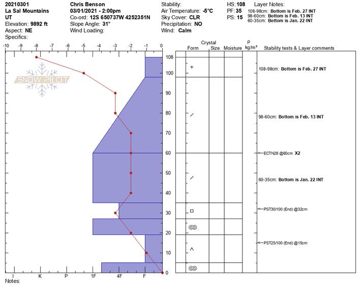
Poor snowpack structure exists with consolidated slabs resting on buried persistent weak layers of loose, sugary, faceted snow on many aspects. However, the snow is getting stronger with time and relatively warm temperatures within the lower snowpack. Extended column tests were not able to produce failures that propagated across the column (ECTN28 x2). Two propagation saw tests did, however, suggest that the "propensity for propagation" is still present (PST30/100 (End) @ 32 cm and 15 cm). The most dangerous areas are on slopes above treeline that face NW-N-SE where wind drifted snow has created slabs 1'-3' deep on top of these buried weak layers. Once triggered, these slab avalanches would be large and destructive.
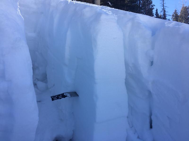
The image below shows the relative hardness of each layer, sort of like rock layers in the Grand Canyon. Picture building blocks stacked on top of one another with varying strengths and thicknesses, and note the very precarious situation between 10-20 cm. This is the layer of weak, sugary snow that the rest of the snowpack is sitting on.
I did notice some weak snow (near surface facets) near the top of the snowpack yesterday. While not a problem now, these small, sugary grains could be an issue once they are buried.
Avalanche Problem #2
Wind Drifted Snow
Type
Location
Likelihood
Size
Description
Northerly ridgetop winds over the weekend have transported the recent, low-density snow, and fresh, potentially unstable drifts have formed on all aspects, primarily in upper elevation wind exposed terrain. Look for fresh drifts on the leeward sides of ridge crests and terrain features like sub-ridges and gully walls. On steep, northerly aspects, wind drifted snow has added additional stress to buried persistent weak layers so it isn't merely a question of identifying and testing for wind slab instability. The bottom line is that steep, wind loaded, northerly-facing terrain remains very much a gamble, and deep and dangerous, human-triggered avalanches remain possible in these areas.
Additional Information
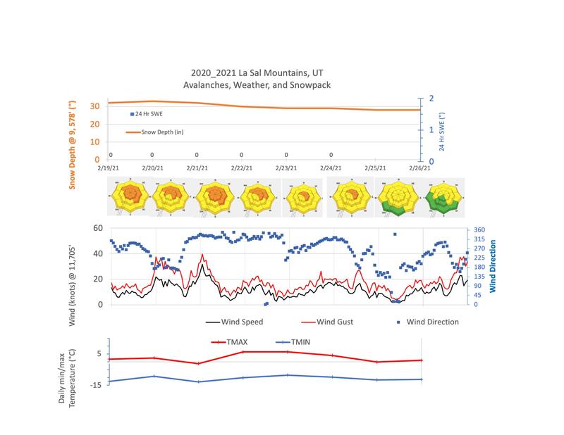
Here is view of last week's weather data.
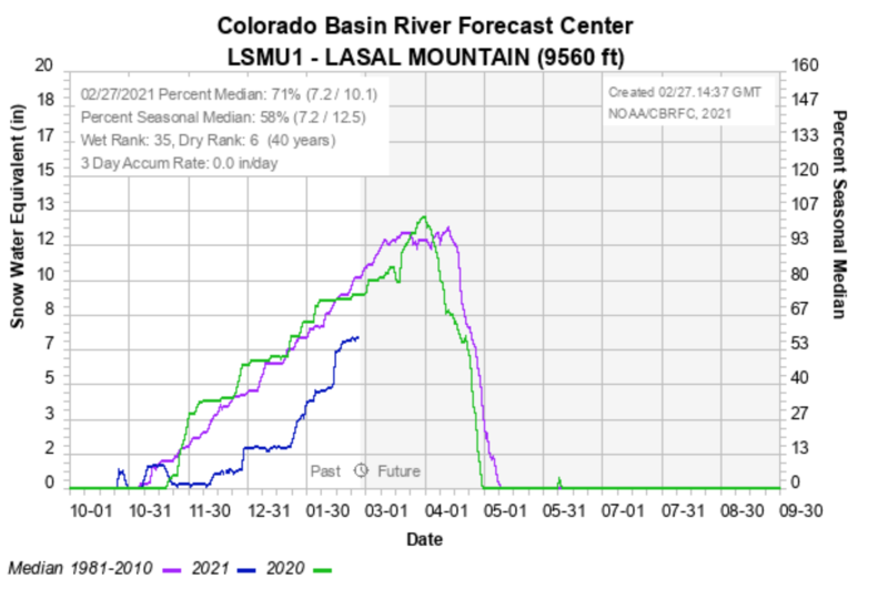
And here are some snowpack data from the Colorado River Basin Forecast Center. We are currently at 71% of normal.
General Announcements
This forecast is from the U.S. Forest Service, which is solely responsible for its content. This forecast describes general avalanche conditions and local variations always occur.