Donate to Our Spring Campaign or Bid on our Spring Auction to Support Forecasting

Forecast for the Moab Area Mountains

Dave Garcia
Issued by Dave Garcia on
Wednesday morning, March 19, 2025
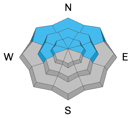
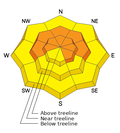
Heavy snowfall and strong shifting winds from a quick-hitting storm combine to create CONSIDERABLE avalanche danger. Human triggered avalanches of wind drifted snow are LIKELY on above treeline slopes that face W-N-SE and near treeline slopes W-N-E. Remaining slopes have a MODERATE danger and human triggered avalanches are possible in drifted snow.
Natural avalanches are POSSIBLE and human triggered avalanches are LIKELY failing on buried persistent weak layers on slopes near treeline and above that face W-N-E where the danger is CONSIDERABLE. These avalanches can break three feet deep or more, be well connected, and run far.
Cautious route-finding and conservative decision making is essential for backcountry travel today. Avoid run out zones and be aware of steep slopes above you.
Low
Moderate
Considerable
High
Extreme
Learn how to read the forecast here
Special Announcements
The Utah Avalanche Center is excited to host Mountainfilm on Tour in Moab at Star Hall on 3/21 and 3/22. Click here for tickets and information.
Our Spring Campaign is in full swing, and there are two great ways to support forecasting, awareness, and education across Utah: Donate to our Spring Campaign, or Bid on items in our Spring Auction. Every dollar donated helps keep the backcountry community on top.
They will be working on the Loop Road today and it will be closed from 8:30-5:30 on the south end. Access to Geyser is from Castle Valley.
Geyser Pass Road: Expect a foot of snow on the road with deeper drifts possible. Four wheel drive is necessary. Chains may be needed to get up today.
Grooming Conditions: The Gold Basin trail was last packed out on Sunday.
Weather and Snow
6 A.M. Snow and Weather Data
24 Hour Snow: 12" 72 Hour Snow: 12" Season Total Snow: 121" Depth at Gold Basin: 60"
Winds on Pre-Laurel Peak: N/A Temp: 9F Percent of Normal (SWE): 91%
Weather
Pre Laurel Peak wind station and the Gold Basin storm stake are down as we install upgrades including a web cam to the site.
Under clear skies it is 9 degrees in Gold Basin this morning. Mountain winds overnight blew from the northwest in the moderate range with strong gusts. Temperatures will remain cool under northerly flow with an expected high of 17 degrees. Winds from the north will blow 15 MPH with gusts up to 30 MPH. Overnight lows will crash to the single digits before climbing back to the upper 20s tomorrow. Cloud cover will build tomorrow and we will see gusty winds from the south. Sunshine returns on Friday, winds ease off a bit and shift to the west.
General Conditions
Yesterday's quick moving and very windy storm dropped a foot of fresh snow (1.2" SWE) on the La Sals. The initial 3" was somewhat dense, and the snow got lighter and fluffier as the day progressed. Skiing and riding should be excellent on all aspects under sunny skies today. Your primary avalanche concern is wind drifted snow. The storm initially began with strong southwest winds which shifted to the northwest later in the day and continued to blow. Maggie Nielsen and company reported widespread blowing and drifting snow, even below tree line. In their travels they saw numerous shooting cracks and triggered some small wind drifts. These are obvious red flags of unstable snow. In addition to recent blowing and drifting snow, our persistent weak layer problem is alive and well. Buried weak layers have been repeatedly pushed to their breaking point with over three feet of snow this month. Expect these layers to be reactive under the weight of the new snow, especially on recently wind loaded slopes.
Snowpack and Weather Data
Gold Basin SNOTEL site (10,000')
SNOTEL site near Geyser Pass Winter Trailhead (9600')
Wind Station on Pre-Laurel Peak (11,400')
NWS forecast for the La Sal Mountains.
Recent Avalanches
Check out this account of an avalanche incident in the Terminal Caner colouir in the Ruby Mountains near the UT/NV border. It's a well written study of human dynamics, and what can happen when you don't listen to your instincts. Fortunately, it turned out okay.
See the complete avalanche database here.
Ad
Avalanche Problem #1
Wind Drifted Snow
Type
Location
Likelihood
Size
Description
The recent storm began with strong southwest winds which shifted to the northwest later in the day and continued to blow overnight. Mountain topography can cause strong winds to swirl and change direction loading any aspect. With plenty of low density snow available for transport, expect to find unstable drifts in unusual places. Wind slabs will be further down off the ridge lines than you might expect and on mid-slope terrain features. Below treeline terrain even gets in on the action today. Use caution while exiting drainage bottoms and avoid terrain traps.
Wind drifted snow is stiffer and more compact than non-drifted snow. Cracking and collapsing is a sure sign of instability. This problem is most pronounced near treeline and above on slopes with a northerly and easterly component to their aspect.
Avalanche Problem #2
Persistent Weak Layer
Type
Location
Likelihood
Size
Description
March has been a great month for skiing with over three feet of snow and more than three inches of snow water equivalent (SWE). It is important to realize all of the recent snow has piled up on a snowpack that has remained shallow and weak all season. A thick, cohesive, and well connected slab exists above this weak structure. Each additional load pushes buried weak layers closer to their breaking point. Weak layers are teetering on the brink, and skiers and riders are likely to trigger deep and dangerous slab avalanches. The most dangerous slopes are steep northerly aspects, especially those that have been recently wind loaded. Travel advice is to stick to slopes less steep than 30 degrees.
Additional Information
Check out the latest UAC podcast with forecaster Brett "Kowboy" Kobernick where he discusses faceted persistent weak layers and how "nobody is immune from getting killed in an avalanche."
Sign up for text alerts to get the most up to date information about changing conditions, road plowing, special avalanche announcements.
Follow us on Instagram @utavy_moab
General Announcements
This forecast is from the U.S.D.A. Forest Service, which is solely responsible for its content. This forecast describes general avalanche conditions and local variations always occur.