Forecast for the Moab Area Mountains

Eric Trenbeath
Issued by Eric Trenbeath for
Saturday, March 19, 2022
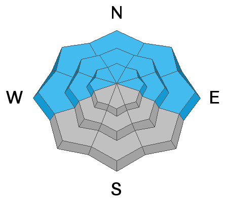
The avalanche danger is MODERATE but the possibility of triggering a deadly avalanche 2'-3' deep on a buried persistent weak layer remains very real. This weak layer is present on all slopes facing W-N-E. These avalanches can be triggered at all elevations but areas of heightened concern are on steep, northerly facing slopes right around treeline. Evaluate snow and terrain carefully and identify features of concern.
A MODERATE danger also exists for human triggered avalanches involving recent deposits of wind drifted snow. Gusty, erratic winds on Thursday deposited fresh drifts on all aspects. They'll be less sensitive today but be on the lookout for unstable wind slabs on the leeward sides of ridge crests and terrain features such as gully walls, sub-ridges, and rocky outcrops. Fresh drifts are recognizable by their smooth rounded appearance and they may sound hollow underneath.
And finally, afternoon clouds may put a damper on things but with warming temperatures today, you'll need to be on the lookout for loose wet avalanche activity on sun exposed slopes facing the south side of the compass. Signs of instability include rollerballs, pinwheels, and sloppy wet snow.
Low
Moderate
Considerable
High
Extreme
Learn how to read the forecast here
Special Announcements
Please help support avalanche forecasting throughout Utah. Donate to the Spring Campaign to help raise the funds to support the forecasting you rely on.
Road Conditions: The road is a mix of dirt, mud, and patches of packed snow. It gets sloppier as the days warm up. All wheel drive and good tires are recommended.
Grooming: The road into Gold Basin was groomed on Thursday.
Weather and Snow
6:00 a.m. weather data:
24 Hour Snow 0" 72 Hour Snow 3" Base Depth at Gold Basin 59" Wind SW 5-15 G25 Temp 17F
A transitory ridge is moving through the area while to the west, a long wave trough is moving on shore. We should see mostly sunny skies with a few high clouds this morning. Clouds will gradually increase this afternoon, thickening and lowering by this evening. SW winds will be mostly light and high temps at 10,000' will approach 40 degrees. Winds will increase tonight and tomorrow will be mostly cloudy with a chance for snow developing after noon. The best chance for snow will be Sunday night and it looks like another 2"-4" storm. By Monday, the storm moves on and we'll see blustery NW winds in the aftermath. Next week looks dry.
Snowpack
3" of new snow fell on Wednesday night but NW winds quickly had their way with it. Exposed slopes took a beating and blowing snow created fresh drifts up to a foot deep on leeward slopes. Cross loading was also a factor and drifts could be found on all aspects on the leeward sides of terrain features such as sub-ridges or rock outcrops. These recent drifts are gradually losing sensitivity but if triggered they could still knock you off your feet or carry you over a cliff band. Out of the wind, the new snow provided a nice refresh in sheltered areas. Strong March sunshine has affected exposed surfaces and breakable crusts abound. Afternoon clouds may put a damper on things but with warming temperatures today, you'll need to be on the lookout for loose wet avalanche activity. Signs of instability include rollerballs, pinwheels, and sloppy wet snow.
The buried persistent weak layer of faceted snow that formed during the Jan-Feb high pressure remains the primary concern, and it is still capable of producing dangerous, human triggered avalanches over two feet deep on all slopes facing the north side of the compass. Here is what I found digging in the snow on Thursday:
Snow and Weather Links
Gold Basin SNOTEL site (10,000')
Storm Totals in Gold Basin
Wind Station on Pre Laurel Peak (11,700')
Recent Avalanches
I'm sorry to report an avalanche fatality in the neighboring San Juan Mountains of Colorado. A lone snowboarder was caught and buried near Trout Lake on a steep, rocky, NW facing slope. We share a similar snowpack, and this is a painful reality check of what it means to have a reactive persistent weak layer. Our hearts go out to all those affected by the tragedy. Here is the preliminary report.
Ad
Avalanche Problem #1
Persistent Weak Layer
Type
Location
Likelihood
Size
Description
A persistent weak layer of loose, sugary faceted snow exists on W-N-E aspects beneath a slab that is 2' -3' thick. The weakest snow can be found on northerly aspects right around treeline and below. Above treeline the weak layer distribution is much more variable and it is hard to track. Stability test show that avalanches are becoming harder to trigger on this weak layer, but the bottom line is that attempting to outsmart this avalanche problem is a dangerous proposition. Likely trigger points include areas of shallow snow, slope margins, rocky outcroppings, and steep convex roll overs. If you are of the mindset to begin creeping into avalanche terrain keep in mind that signs of instability will no longer be obvious but that is not necessarily an indication of stability.
Avalanche Problem #2
Wind Drifted Snow
Type
Location
Likelihood
Size
Description
Moderate to strong northerly winds on Thursday formed fresh wind drifts up to a foot deep. Although S and W facing slopes were the primary deposition zones, cross loading allowed drifts to form on northerly facing slopes as well. Look for fresh drifts on the leeward sides of ridge crests and terrain features such as sub ridges, gully walls, and rock outcrops. Wind slabs will be more stubborn to release today, and they are mostly shallow, but they have added complexity to the snowpack and if triggered they could knock you off your feet, or even worse, lead to the release of a slab on the buried persistent weak layer. Recent drifts are recognizable by their smooth rounded appearance and they may sound hollow underneath. Scalloped or rippled surfaces are also signs of wind loading. Avoid steep slopes where you can detect recent deposits of wind drifted snow.
Peter Golde was down visiting from Ogden, Utah and he shared this photo of a cracking wind slab under foot. They'll be much less sensitive today.
Avalanche Problem #3
Wet Snow
Type
Location
Likelihood
Size
Description
Clouds may put a damper on it by this afternoon, but wet loose avalanches may be possible on slopes facing W-S-E today as the day heat up. Be on the lookout for signs of instability such as rollerballs, and pinwheels, and get off of steep slopes if they become wet and sloppy.
General Announcements
Who's up for some free avalanche training? Get a refresher, become better prepared for an upcoming avalanche class, or just boost your skills. Go to https://learn.kbyg.org/ and scroll down to Step 2 for a series of interactive online avalanche courses produced by the UAC.
This forecast is from the U.S.D.A. Forest Service, which is solely responsible for its content. This forecast describes general avalanche conditions and local variations always occur.