Forecast for the Moab Area Mountains

Eric Trenbeath
Issued by Eric Trenbeath for
Monday, March 14, 2022
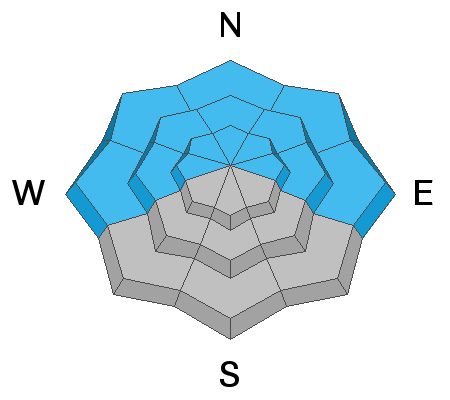
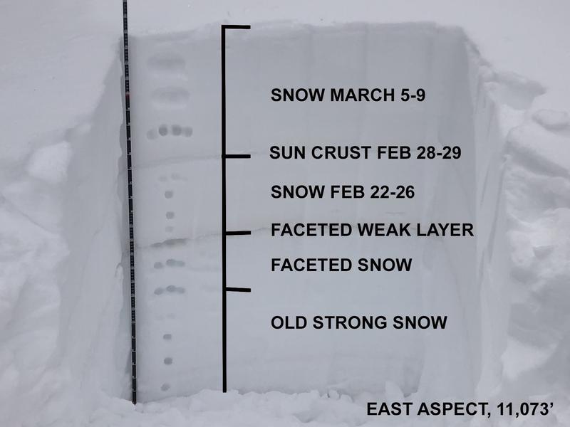
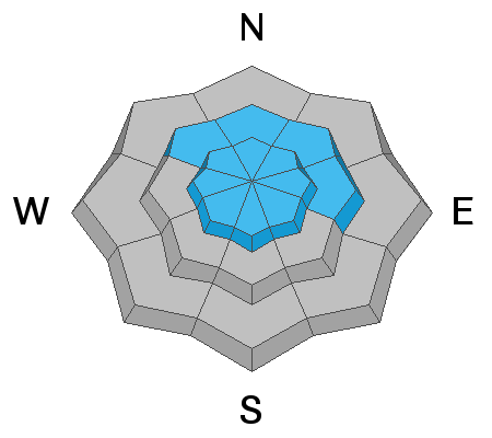
Areas of CONSIDERABLE avalanche danger remain on steep slopes facing NW-N-NE-E and human triggered avalanches failing on a buried persistent weak layer 2-3 feet deep are likely. It's not yet time to go big down here so keep your aspirations low if you are planning a trip to the La Sals. A MODERATE danger for triggering this type of avalanche exists on W facing slopes. Most S facing terrain has LOW danger but as the sun warms things up today be alert to signs of loose wet instability such as rollerballs or pinwheels and get off of steep slopes if they become wet and sloppy.
Low
Moderate
Considerable
High
Extreme
Learn how to read the forecast here
Special Announcements
Road Conditions: The road is a mix of dirt, mud, and patches of packed snow. It gets sloppier as the days warm up. All wheel drive and good tires are recommended.
Grooming: Trails have not been groomed since last week but they are well packed from traffic.
Weather and Snow
6:00 a.m. weather data:
24 Hour Snow 1" 72 Hour Snow 1" Base Depth at Gold Basin 60" Wind NW 15-20 G35 Temp 20F
After depositing an inch of snow, last night's storm system is exiting the region and a transitory ridge is set to build through Tuesday. Today look for sunny skies, decreasing northwesterly winds, and high temps in the low 30's. On Tuesday, temps will be much warmer, rising up into the low 40's. On Wednesday, another low pressure trough out of the Pacific Northwest dives into the region. This doesn't look like much of producer either but we may squeeze out a few inches of snow. Mostly sunny conditions finish out the week.
Snowpack
Spring took over in the mountains over the weekend and all sun exposed surfaces, including some low angle northerly aspects, are crusted over. On steeper, sheltered, northerly facing slopes the snow remains cold and dry and deceptively dangerous avalanche conditions still exist, especially for this time of year. You know by now that this is due to the presence of a buried persistent weak layer of faceted snow that formed during the Jan-Feb high pressure. In my travels yesterday I continued to find this layer to be reactive, and as much as the danger may be slowly trending downward, the likelihood for triggering an avalanche 2'-3' deep on a steep, slopes facing NW-N-NE-E remains all to real. You can get more of the details in my observation and in the video below.
Snow and Weather Links
Gold Basin SNOTEL site (10,000')
Storm Totals in Gold Basin
Wind Station on Pre Laurel Peak (11,700')
Recent Avalanches
It was an active weekend throughout the state for human triggered avalanches with almost all of the other zones reporting accidents and near misses. I commend the restraint of our users who generally play it safe down here.
Ad
Avalanche Problem #1
Persistent Weak Layer
Type
Location
Likelihood
Size
Description
A persistent weak layer of loose, sugary faceted snow exists on W-N-E aspects beneath a slab that is 2' -3' thick. This problem is most pronounced on slopes facing NW-N-NE-E near treeline and below. Above treeline the weak layer distribution is much more variable and it is hard to track, but where it does exist, wind drifted snow has has helped to overload it. In my travels yesterday, I continued to experience localized collapsing near tree line on shady slopes and stability tests continued to produce failures in snow pits. As time goes on and things begin to stabilize, outward signs of instability will lessen and we'll be more tempted to venture into steeper terrain. But with the knowledge of what's underneath, it will be hard for me to justify going on to steep, northerly facing slopes for some time.
This image illustrates the snowpack history from when it quit snowing on December 31, through now. To see how the snow nerds record this information, scroll down to additional information.
Avalanche Problem #2
Wind Drifted Snow
Type
Location
Likelihood
Size
Description
Shifting winds over the past week have blown and drifted snow on to all aspects at upper elevations and there may be a few, unstable wind slabs lurking about. On northerly aspects, drifted snow has added more weight and stress to the buried persistent weak layer increasing the likelihood for a deeper, more dangerous avalanche. Wind drifts are recognizable by their smooth, rounded appearance and cracking is a sign of instability. Avoid steep wind drifted slopes, especially those facing the north side of the compass.
Additional Information
Here is a profile from a pit I dug on Sunday on an east aspect at 11,000' above Geyser Pass. The layer/s of concern are between 130-150 cms.
General Announcements
Who's up for some free avalanche training? Get a refresher, become better prepared for an upcoming avalanche class, or just boost your skills. Go to https://learn.kbyg.org/ and scroll down to Step 2 for a series of interactive online avalanche courses produced by the UAC.
This forecast is from the U.S.D.A. Forest Service, which is solely responsible for its content. This forecast describes general avalanche conditions and local variations always occur.