Donate to Our Spring Campaign or Bid on our Spring Auction to Support Forecasting

Forecast for the Moab Area Mountains

Eric Trenbeath
Issued by Eric Trenbeath on
Thursday morning, March 13, 2025
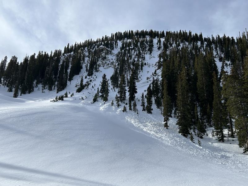
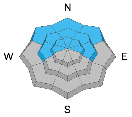
The avalanche danger is MODERATE on steep slopes that face W-N-E and it is POSSIBLE for skiers and riders to trigger avalanches failing on deeply buried persistent weak layers. The danger is most pronounced on steep northerly slopes near treeline. While the likelihood of triggering a slide has decreased, the consequences remain severe. Any slide failing on facets will be deep, dangerous, and potentially unsurvivable.
Expect the danger to rise overnight with the arrival of a windy storm system that should bring periods of heavy snow.
Low
Moderate
Considerable
High
Extreme
Learn how to read the forecast here
Special Announcements
The Utah Avalanche Center is excited to host Mountainfilm on Tour in Moab at Star Hall on 3/21 and 3/22. Click here for tickets and information.
March kicks off our Spring Campaign! If everyone in Utah’s backcountry community donates the cost of something they regularly enjoy on an adventure—like a dawn patrol burrito, a backpack snack, or post-ride trailhead drinks—we could fund not just one but two forecasters for the entire season! Donate here. Thank you!
Geyser Pass Road: The road is plowed and is mostly down to the dirt. Roadwork continues today on La Sal Mountain Loop Road and a closure is in place from 8:30 AM to 5:30 PM.
Grooming Conditions: Trails have not been groomed since last Friday.
Weather and Snow
6 A.M. Snow and Weather Data
24 Hour Snow: 0" 72 Hour Snow: 0" Season Total Snow: 97" Depth at Gold Basin: 42"
Winds on Pre-Laurel Peak: N/A Temp: 28° F Percent of Normal (SWE): 86%
Weather
Pre Laurel Peak wind station and the Gold Basin storm stake are down as we install upgrades including a web cam to the site.
Southwest winds began to ramp up overnight ahead of the next storm system moving into our area. Look for increasing clouds and strong southerly winds averaging 20-25 mph with gusts as high as 50 along ridge tops. High temperatures will be in the low 30's at 10,000', We may see a few isolated showers today with real snowfall beginning this evening. 6"-10" are possible overnight. It should be mostly over by tomorrow morning. Look for gradually clearing skies and moderate to strong westerly winds. A second wave on a northwest flow brings another chance for an inch or two of snow Friday night into Saturday. Sunday looks sunny with an unsettled pattern starting off the week.
General Conditions
It's going to be a little rugged out there today with a variety of wind and sun crusted surfaces and cloudy and windy conditions. Warm temperatures and sunny skies this week have melted many south aspects back down to the dirt and from town, the mountains look like we are well into late spring. On northerly aspects however, we still have a winter snowpack that looks like January underneath. Layers of weak, faceted snow make up the bottom two thirds of the snowpack, while on top we have a dense, hard slab 2-4 feet thick. Cumulative snowfall last week put pressure on these buried weak layers of faceted snow producing several large avalanches. The likelihood of triggering this type of avalanche has decreased, but the consequences remain devastating. Most of these slides occurred on steep, northeasterly aspects right around treeline but a persistent weak layer problem still exists on steep slopes facing W-N-E.
Snowpack and Weather Data
Gold Basin SNOTEL site (10,000')
SNOTEL site near Geyser Pass Winter Trailhead (9600')
Wind Station on Pre-Laurel Peak (11,400')
NWS forecast for the La Sal Mountains.
Recent Avalanches
It's been almost a week since the last loading event and subsequent avalanche activity but in his travels on Tuesday, Dave spotted this avalanche in the Snaggletooth Chutes. The slide most likely occurred the night of 3/7 during the strong NE wind event. This slope is near treeline, north-facing, steep, and rocky. This is the bullseye location for our current avalanche problem.
See the complete avalanche database here.
Ad
Avalanche Problem #1
Persistent Weak Layer
Type
Location
Likelihood
Size
Description
A key point to remember is that for much of the season, the snowpack has been very shallow. Shallow snow is weak snow, and the faceted layers have remained weak all season long. Typically, by this time of year, we have a deeper snowpack and the facets have had a chance to gain some strength. For now, we have to continue to exercise patience and make careful terrain choices while we wait for this problem to go away. Poor snowpack structure is widespread, and recent stability tests have produced stubborn results. Steep northerly slopes near treeline are the bullseye location for this problem. You are unlikely to see in your face red flag indicators today like collapsing and cracking, but deep, destructive, and deadly human-triggered avalanches remain a real possibility.
The PWL remains active on west-facing slopes, but the avalanche problem is specific to slopes with a relatively deep and layered snowpack. Some west aspects are very thin due to warm temperatures, sun, and wind. These slopes do not pose much of a threat. The only way to know is to probe for depth and dig down to look for weak layers.
Additional Information
Check out the latest UAC podcast with forecaster Brett "Kowboy" Kobernick where he discusses faceted persistent weak layers and how "nobody is immune from getting killed in an avalanche."
Sign up for text alerts to get the most up to date information about changing conditions, road plowing, special avalanche announcements.
Follow us on Instagram @utavy_moab
General Announcements
This forecast is from the U.S.D.A. Forest Service, which is solely responsible for its content. This forecast describes general avalanche conditions and local variations always occur.