Forecast for the Moab Area Mountains

Dave Garcia
Issued by Dave Garcia for
Wednesday, March 13, 2024
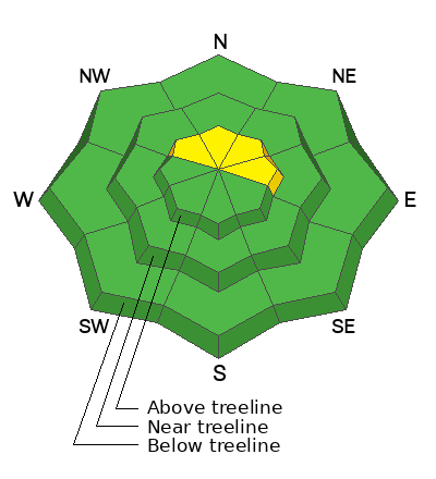
This morning, most terrain offers a LOW danger. You will find a MODERATE danger above treeline on slopes that face NW-N-NE-E, where it is possible to trigger small avalanches in hard slabs of wind-drifted snow.
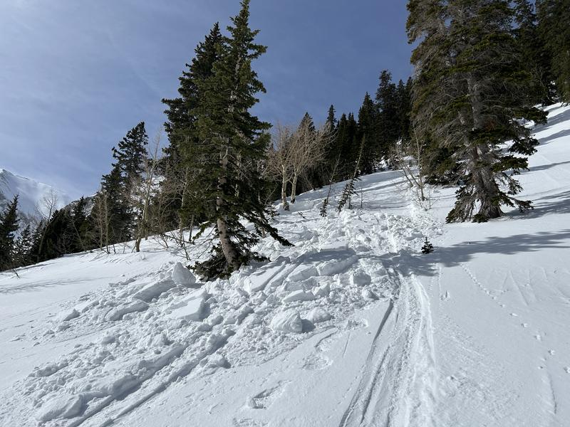
On shady slopes, near treeline and below, we are tracking a weak layer of faceted snow that exists just below the surface. The distribution of this layer is spotty at best, but it is found in steep, sparsely treed, Northerly facing terrain. As snow stacks up over the next few days, and the wind blows, this layer is capable of producing avalanches.
Incoming storms this week will cause a rise in the avalanche danger. It is no longer open season, and savvy backcountry travelers will be stepping-back and reassessing changing conditions.
Low
Moderate
Considerable
High
Extreme
Learn how to read the forecast here
Special Announcements
Road Conditions: The Geyser Pass Road to the winter trailhead is plowed. A few inches may accumulate on the road today.
Grooming: Trails were groomed a few days ago by LUNA.
Newly released; "To the Hills & Back" is a heart-wrenching documentary by the UAC
***Support the UAC website rebuild by donating to our spring campaign. Save lives by making a donation today! HERE
Weather and Snow
6:00 a.m. Snow and Weather Data
24 Hour Snow 1" 72 Hour Snow 1" Season Total Snow 147" Depth at Gold Basin 53"
Winds on Pre-Laurel Peak: 11-14 SW Temp 24° F Percent of Normal: 94%

Weather
A strong cold front is moving through our region, delivering cold temperatures and accumulating snow. Temperatures will be 5-10 degrees below normal this week. Today we can expect a high of 20 degrees in Gold Basin. Winds will blow out of the West at 10-15 MPH. We will see light snow today, with maybe 2-5" of accumulation. A closed low brings more substantial moisture in from the South on Friday. This storm looks more impressive than today's event. Lingering snow showers may persist into Saturday night.
General Conditions
Backcountry travelers reported stellar conditions over the weekend, but unfortunately, skiing and riding conditions have taken a hit from Monday's strong winds. Solar aspects are hard and crusted over. Yesterday I found variable conditions on Northerly aspects. Open slopes that have been exposed to the wind have been stripped of their soft powder. These slopes offer a variety of wind textures, and I found some shallow, stubborn hard slabs of wind-drifted snow spread across the terrain. A few inches of snow today should help freshen things up a bit.
Your primary avalanche problem today is lingering hard slabs of wind-drifted snow that formed in alpine terrain during Monday's strong Southerly winds. These hard slabs exist above treeline on slopes that face NW-N-NE-E. Additionally, we have been tracking a weak layer of faceted snow in the upper pack, just a few inches below the surface. We have been finding very weak snow on some Northerly facing slopes near treeline and below. The distribution of this layer is spotty at best, and I need to investigate it further, but it seems to be popping up in isolated areas of steep, sparsely treed terrain. This layer should be on your radar because it is very sensitive, and as slabs build over the next few days, I expect this layer to show its hand and produce more avalanches. Given its high sensitivity, expect collapsing and cracking to be associated with this layer. For more information on this, be sure to read about my travels yesterday.

Snowpack and Weather Data
Gold Basin Storm Stake (10,000')
Gold Basin SNOTEL site (10,000')
SNOTEL site near Geyser Pass Winter Trailhead (9600')
Wind Station on Pre-Laurel Peak (11,400')
NWS forecast for the La Sal Mountains.
Recent Avalanches
Yesterday, a skier triggered this small avalanche of wind-drifted snow. The avalanche was 1 foot deep and about 25 feet wide, failing on the very weak layer of facets described above. This is a NE facing slope at 10,500'. Click here for more information about this avalanche.
Ad
Avalanche Problem #1
Wind Drifted Snow
Type
Location
Likelihood
Size
Description
Lingering hard slabs exist in alpine terrain from Monday's moderate to strong Southerly winds. While pockety in nature, you are most likely to find them on Northerly-facing slopes above treeline. Hard slabs of wind-drifted snow often sound hollow and drum-like, and have a tendency to allow you to get far out onto them before breaking above you. These avalanches will be small in size, but given their location in the alpine, they are dangerous because they can easily push you around.
Additional Information
Want some more insight into the La Sal Mountains as well as the communal impacts of a tragic avalanche? Check out the latest UAC podcast with forecaster Eric Trenbeath where he discusses the range, it's often treacherous snowpack, and how the devastating avalanche in February, 1992, affected the Moab community.
Our avalanche beacon checker sign and beacon training park are up and running. A huge thanks to Talking Mountain Yurts for sponsoring those this season!
Sign up for forecast region-specific text message alerts. You will receive messages about changing avalanche conditions, watches, warnings and road plowing closures.
Follow us on Instagram @utavy_moab
General Announcements
This forecast is from the U.S.D.A. Forest Service, which is solely responsible for its content. This forecast describes general avalanche conditions and local variations always occur.