Forecast for the Moab Area Mountains

Dave Garcia
Issued by Dave Garcia for
Tuesday, March 1, 2022
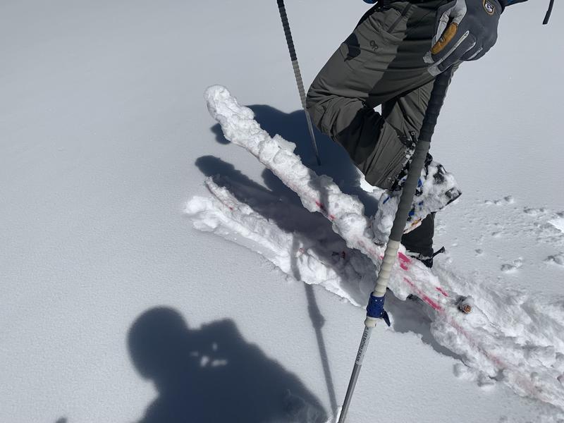
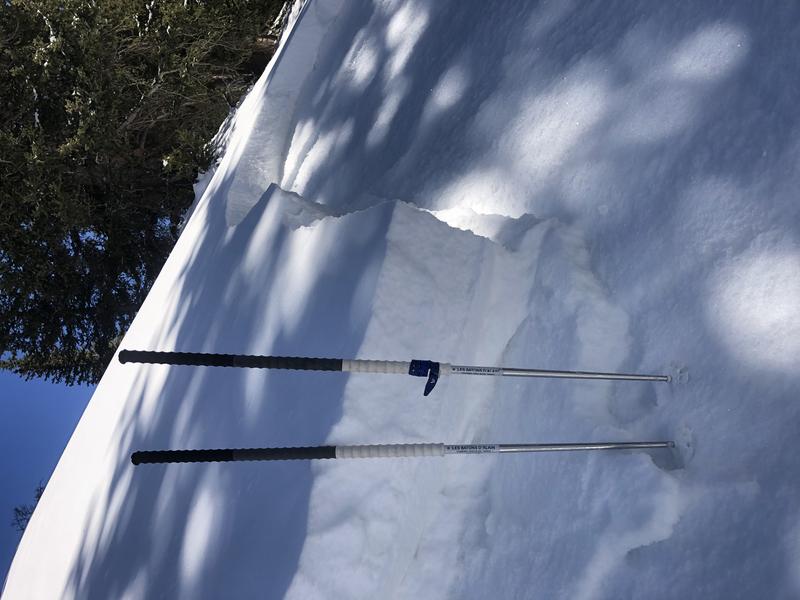
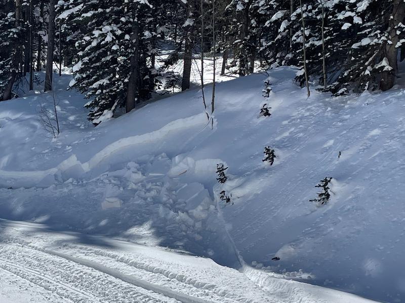
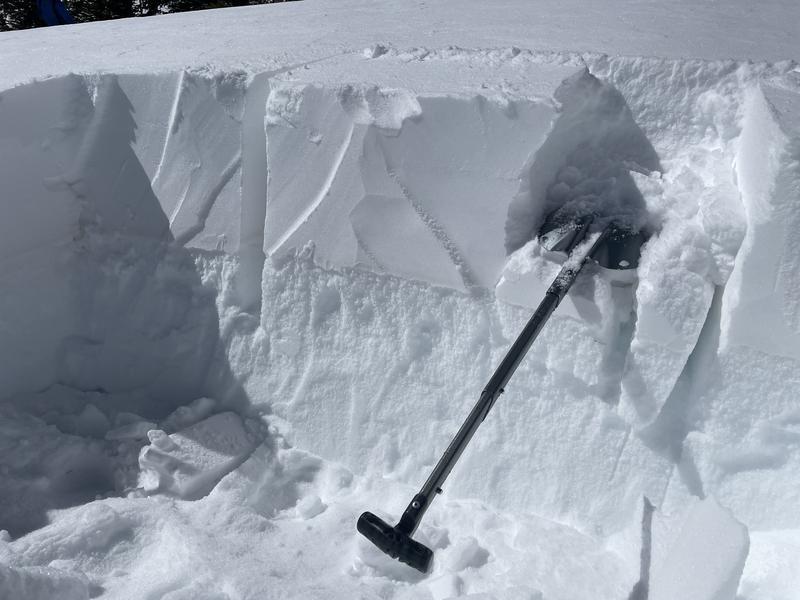
It will be a beautiful day in the mountains, but do not let your guard down. There is a slab present on a widespread weak layer of facets, and it continues to give obvious signs of instability. The avalanche danger remains CONSIDERABLE and human triggered avalanches are likely on slopes facing W-N-SE where this weak layer exists.
Human triggered avalanches are possible on all other slopes and the danger is MODERATE. As the day heats up be alert to signs of wet snow instability on sun exposed slopes.
Low
Moderate
Considerable
High
Extreme
Learn how to read the forecast here
Special Announcements
Road Conditions: The road is plowed. AWD and good tires are recommended. Warms temps are making things a bit sloppy, expect mud down low.
Grooming: LUNA Matt groomed into Gold Basin on Friday. Follow LUNA on Instagram @luna_moab.
Weather and Snow
6:00 a.m. weather data:
24 Hour Snow 0" 72 Hour Snow 0" Base Depth at Gold Basin 52" Wind NE 5-10 Temp 18F
We can expect clear sunny skies today. This morning winds are blowing 5 - 10 out of the NE. The warming trend continues today, 10,000 ft. temperatures will top out close to 40 degrees. Things will cool off by Friday with another chance for snow starting Friday and into the weekend.
NWS Weather Forecast for the La Sal Mountains
Gold Basin SNOTEL site (10,000')
Storm Totals in Gold Basin
Wind Station on Pre Laurel Peak (11,700')
Snowpack
I found wet snow on solar aspects on Sunday and temperatures were in the high 30's yesterday. Cold temps overnight will leave a thin crust on sunny slopes. Good powder skiing can still be found on sheltered northerly slopes. The main avalanche problem is a layer of weak, faceted snow underneath the new snow from last week that is still reactive and keeping our terrain choices conservative.
Photo shows the wet snow Sunday sticking to a ski with no skins on.
Recent Avalanches
Heavy snow and strong SW winds caused a small cycle of natural activity last week during the storm. Eric, Trent, and Mark experienced touchy avalanche conditions while sledding in Dark Canyon on Saturday. On Sunday I triggered this avalanche 2 ft deep and 25 ft wide. I triggered the slide on a steep, shady West facing roll over.
Photo of a road cut bank making a very small avalanche on Saturday near Dark Canyon but also giving a clear indication of stability (Staples).
Ad
Avalanche Problem #1
Persistent Weak Layer
Type
Location
Likelihood
Size
Description
We are five days out from the last snow, but myself and local observers are getting plenty of feedback from the snow telling us that human triggered avalanches are likely. You will find a buried weak layer of facets under the new snow on aspects facing W through SE. You will even find this weak layer in the mid elevations. In fact, the weak layer is better preserved and more widespread at mid elevations. Tim Matthews experienced collapsing at low elevations yesterday. Prior to the storm the alpine was hammered by wind and sun, leaving a spotty distribution of this buried layer up high. As time goes on this layer will be harder to trigger, but right now I am not trusting any slope that harbors buried facets. On Sunday a snow pit revealed this weak layer on a W facing slope above 11,000 ft. My pit produced an ECTP 11. My partner and I bailed on this slope after this result. The bottom line right now is if you find buried facets keep your slope angles down or head to another run.
Very warm temperatures this week may eventually have a stabilizing effect on this weak layer, but this type of healing takes time. And with how much the snow is talking to us lately it's going to be a while before I have much confidence skiing avalanche terrain.
Photo below shows buried facets in the bottom of the snow profile (Staples).
Avalanche Problem #2
Wet Snow
Type
Location
Likelihood
Size
Description
Temperatures will soar to almost 40 degrees F and it's time to be aware of wet activity on solar aspects. Sluffs and point releases of new snow may become possible today on slopes receiving direct sunshine. Many of these slope were nearly bare ground prior to last week's snowfall, but I would pay attention to how quickly the snow warms and become wet on south aspects today. The wetter it gets, the more likely wet loose avalanches will become.
General Announcements
Who's up for some free avalanche training? Get a refresher, become better prepared for an upcoming avalanche class, or just boost your skills. Go to https://learn.kbyg.org/ and scroll down to Step 2 for a series of interactive online avalanche courses produced by the UAC.
This forecast is from the U.S.D.A. Forest Service, which is solely responsible for its content. This forecast describes general avalanche conditions and local variations always occur.