31st Annual Backcountry Benefit - September 12th - Tickets Available Here!

Forecast for the Moab Area Mountains

Eric Trenbeath
Issued by Eric Trenbeath on
Friday morning, February 9, 2024
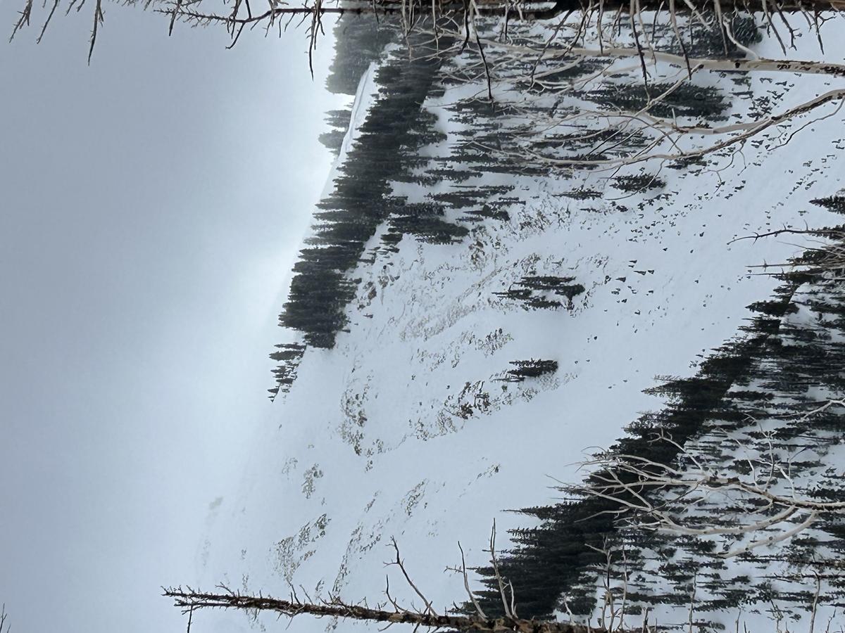
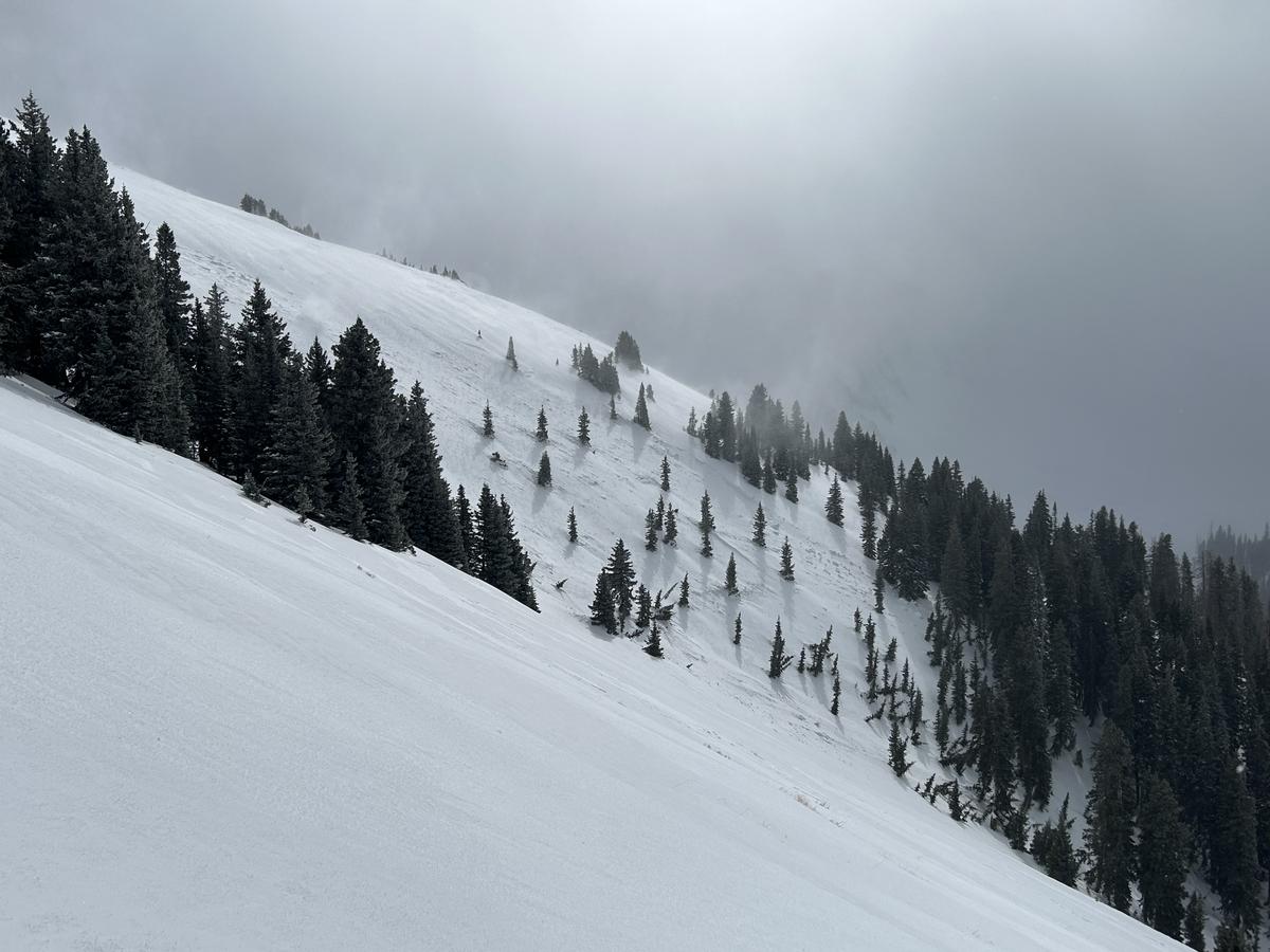
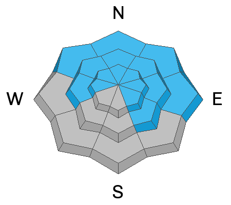
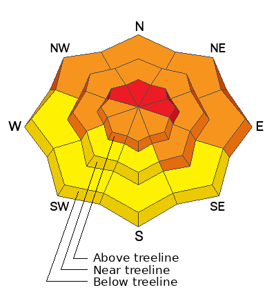
The avalanche danger is HIGH on steep slopes above treeline that face NW-N-E. Deep and dangerous, human triggered avalanches are very likely in these areas and natural avalanches are possible.
The danger is CONSIDERABLE on slopes facing W-N-NE-SE near treeline, and on slopes facing NW-NE-E below, where human triggered avalanches failing on a persistent weak layer are likely.
A MODERATE danger exists on SW-S facing slopes near treeline and below, and on all slopes facing the south side of the compass at low elevations.
Low
Moderate
Considerable
High
Extreme
Learn how to read the forecast here
Avalanche Warning
THE FOREST SERVICE UTAH AVALANCHE CENTER IN MOAB HAS ISSUED AN AVALANCHE WARNING FOR THE ABAJO/BLUE MOUNTAINS OF SOUTHEAST UTAH.
*TIMING...6 AM MST FRIDAY THROUGH 6 AM MST SATURDAY.
*AFFECTED AREA...THE ABAJO/BLUE MOUNTAINS OF SOUTHEAST UTAH
*AVALANCHE DANGER...THE AVALANCHE DANGER REMAINS HIGH.
*REASON/IMPACTS...HEAVY SNOWFALL HAS OVERLOADED PRE EXISTING WEAK LAYERS IN THE SNOWPACK CREATING DANGEROUS AVALANCHE CONDITIONS. NATURAL AND HUMAN TRIGGERED AVALANCHES ARE LIKELY.
Special Announcements
Road Conditions: The Geyser Pass Road will be closed for plowing this morning.
Grooming: Ben rolled out Gold Basin yesterday but trails will be covered in fresh snow today.
Grand Country Search and Rescue will be conducting a training exercise on Saturday. Please be prepared for traffic and much activity between the winter trailhead and Geyser Pass.
A pair of Black Diamond ski poles was left at the trailhead yesteday. They are by the winter trailhead trailer.
Weather and Snow
6:00 a.m. Snow and Weather Data
24 Hour Snow 8" 72 Hour Snow 23" Season Total Snow 130" Depth at Gold Basin 58"
Winds on Pre-Laurel Peak: S 10-15 Temp 15 Percent of Normal: 113%

Weather
Light snowfall this morning should taper off fairly quickly today. Look for cloudy skies, light to moderate southwesterly winds, and high temps near 20F. Cloudy conditions and a chance for snow continue tomorrow. Sunday looks sunny and cool with mostly dry conditions up for next week.
General Conditions
It looks like about 8" of new snow this morning. ESE winds blew in the 15-25 mph range for a few hours overnight but have been well behaved since about 1:00 a.m. We took a trip up Noriega's Ridge yesterday and found excellent, creamy conditions. The density made it impossible to tell that we received up to a foot of snow on Wednesday, and winds during that period didn't help as they scoured southerly aspects and built dense slabs on northerlies. Conditions remain very dangerous, particularly on northerly aspects where recent and wind drifted snow over the past week have produced numerous natural avalanches down to a a buried persistent weak layer. A very large, likely human triggered avalanche last Sunday, demonstrates what is possible. Continue to avoid avalanche terrain, especially on steep slopes facing W-N-E-SE.
Snowpack and Weather Data
Gold Basin Storm Stake (10,000')
Gold Basin SNOTEL site (10,000')
SNOTEL site near Geyser Pass Winter Trailhead (9600')
Wind Station on Pre-Laurel Peak (11,400')
NWS forecast for the La Sal Mountains.
Recent Avalanches
Many avalanches have occurred over the past week. Dave observed this avalanche in Exxon's Folly on Wednesday that failed on a persistent weak layer, and if you look closely at the next ridge back to the right you can see another deep crown in Dory Canyon.
Dave also observed this avalanche in the Funnel, full details here. This avalanche invloved wind drifted snow, and it's only the second avalanche I have ever seen in this location.
Ad
Avalanche Problem #1
Persistent Weak Layer
Type
Location
Likelihood
Size
Description
Persistent weak layers that formed in November and December have reared their ugly heads producing numerous deep and dangerous avalanches over the past week. Human triggered avalanches failing on these weak layers remain likely on steep slopes facing W-N-E-SE. On steep, northerly aspects, human triggered avalanches are very likely. These are very dangerous avalanches, and would most likely be unsurvivable. We simply need to wait out this storm cycle, and see how the weak layer adjusts to the new load before getting into any steep terrain. Stick to low angle slopes (less than 30 degrees) for safe and fun riding today.
Avalanche Problem #2
New Snow
Type
Location
Likelihood
Size
Description
With yet another foot of new snow since the early hours of yesterday morning, avalanches will be possible on steep slopes on all aspects today. But by far, the greatest concern remains on slopes facing W-N-E-SE, where recent and wind drifted snow has overloaded buried persistent weak layers in the snowpack. Deep and dangerous avalanches remain likely in these areas.
Additional Information
Want some more insight into the La Sal Mountains as well as the communal impacts of a tragic avalanche? Check out the latest UAC podcast with forecaster Eric Trenbeath where he discusses the range, it's often treacherous snowpack, and how the devastating avalanche in February, 1992, affected the Moab community.
Our avalanche beacon checker sign and beacon training park are up and running. A huge thanks to Talking Mountain Yurts for sponsoring those this season!
Sign up for forecast region-specific text message alerts. You will receive messages about changing avalanche conditions, watches, warnings and road plowing closures.
Follow us on Instagram @utavy_moab
General Announcements
This forecast is from the U.S.D.A. Forest Service, which is solely responsible for its content. This forecast describes general avalanche conditions and local variations always occur.