31st Annual Backcountry Benefit - September 12th - Tickets Available Here!

Forecast for the Moab Area Mountains

Dave Garcia
Issued by Dave Garcia on
Thursday morning, February 8, 2024
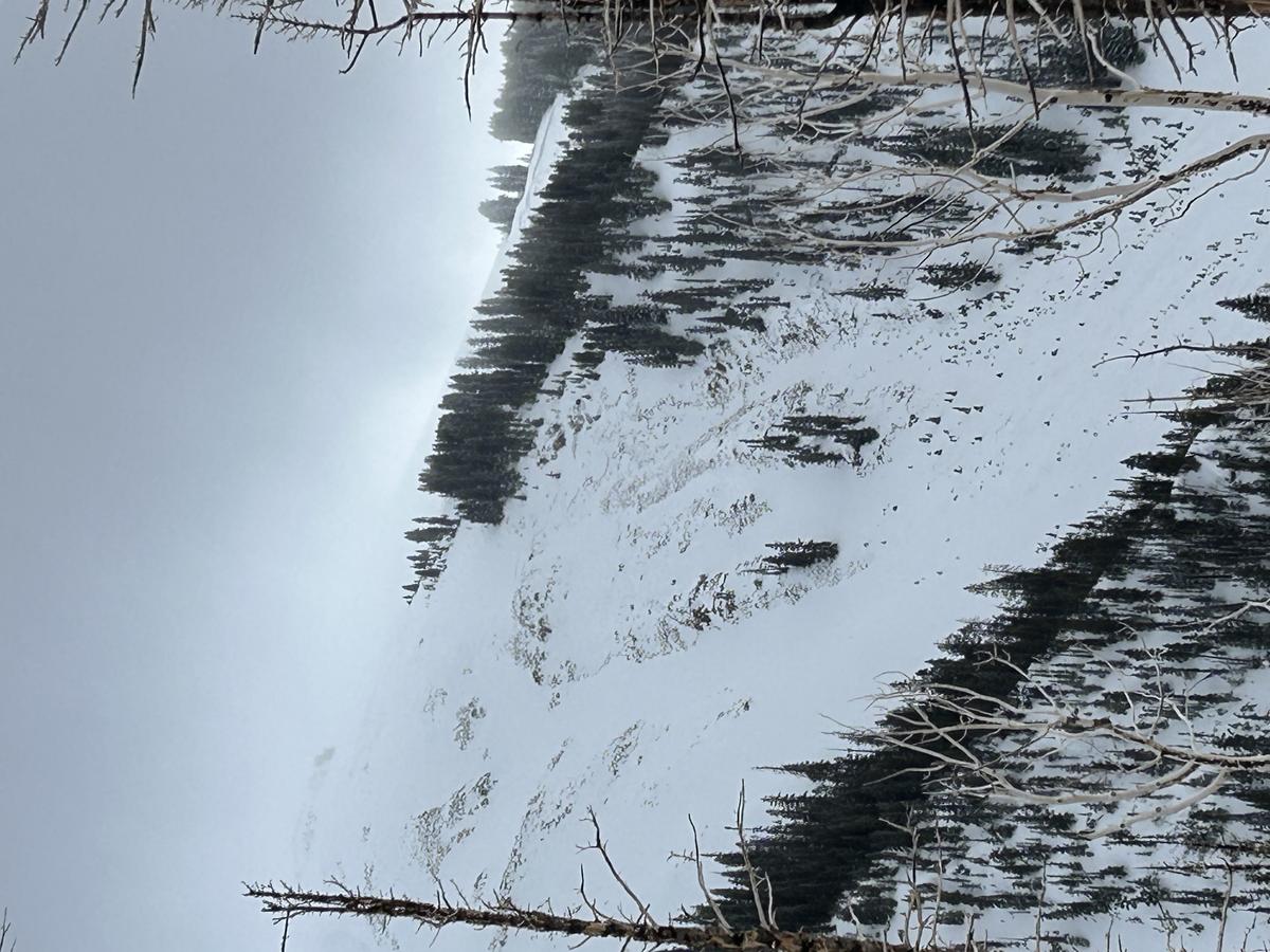
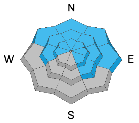
Recent heavy snow and strong winds have created CONSIDERABLE avalanche danger in the La Sal Range. Natural avalanches are POSSIBLE, and human-triggered avalanches are LIKELY failing on a persistent weak layer (PWL) of faceted snow buried three feet beneath the surface. This PWL exists on all slopes that face NW-N-NE-E and on slopes that face W and SE near treeline and above.
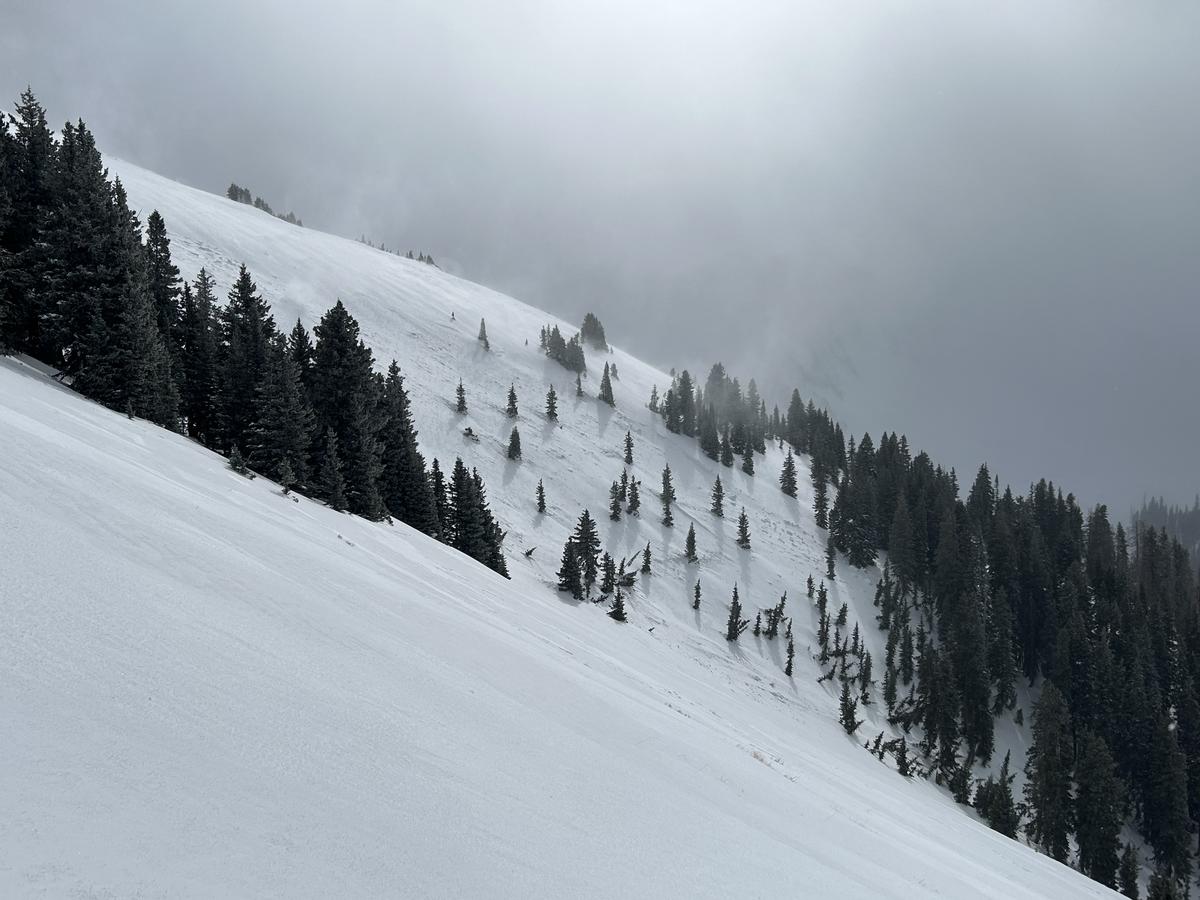
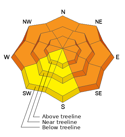
Both soft and hard slabs of wind-drifted snow exist around the compass, and skiers and riders are LIKELY to trigger avalanches today in wind-drifted snow. This problem is not limited to Northerly aspects and avalanches failing in wind-drifted snow remain POSSIBLE on slopes that face SW and S where there is a MODERATE danger.
These are dangerous avalanche conditions. Cautious route-finding and conservative decision-making are essential today for backcountry travel.
Low
Moderate
Considerable
High
Extreme
Learn how to read the forecast here
Special Announcements
Road Conditions: The Geyser Pass Road has not been plowed. Driving conditions were very easy yesterday. All of the new snow fell above the winter TH. Additional accumulation and blowing and drifting snow today may create challenging conditions as the day progresses.
Grooming: Trails will be snow covered today.
Weather and Snow
6:00 a.m. Snow and Weather Data
24 Hour Snow 3" 72 Hour Snow 15" Season Total Snow 122" Depth at Gold Basin 50"
Winds on Pre-Laurel Peak: SSW 18 G 30 Temp 18 Percent of Normal: 113%

Weather
Light snow is falling under cloudy skies this morning and it is currently 18 degrees. High temperatures will remain right around 20 degrees. Winds will blow out of the Southwest at 15-25 MPH. Light snow showers will continue today, with little accumulation. We may see an additional 1-3" today. Widely scattered to moderate snow showers will continue tonight into Friday. The overnight period looks somewhat promising with the potential for another 3-6". Light showers linger through Friday and Saturday, but these storms don't look too impressive at the moment. Things will clear out on Sunday.
General Conditions
Yesterday was a wild windy day. We were out and about in the wind, and you can read our full report here. We found a foot of new snow, but it was very heavy and dense. Ski penetration was only a couple of inches. The new snow skied like styrofoam, but it actually made for really fun skiing as reported by Sam Van Wetter. Another three inches of snow has stacked up early this morning, which should improve riding conditions. Strong Southerly winds stripped any windward face, and in some places, it was hard to tell that it even snowed. Stiff slabs of wind-drifted snow exist around the compass, waiting like booby traps for the weight of a skier or rider to come along and trigger them. We observed one natural avalanche involving wind-drifted snow. We also observed one natural avalanche involving the buried persistent weak layer (PWL). The PWL is stressed right to its breaking point from all of the new and drifting snow. Humans can easily trigger deep and dangerous avalanches failing on the PWL today.
Snowpack and Weather Data
Gold Basin Storm Stake (10,000')
Gold Basin SNOTEL site (10,000')
SNOTEL site near Geyser Pass Winter Trailhead (9600')
Wind Station on Pre-Laurel Peak (11,400')
NWS forecast for the La Sal Mountains.
Recent Avalanches
Yesterday we observed two natural avalanches in the backcountry. The first was a large avalanche failing on the PWL on Exxon's Folly full details here.
The second was an avalanche involving a soft slab of wind-drifted snow failing on the old snow interface in the upper Funnel full details here. What is significant about this slide, is this is the first time I have seen an avalanche on this slope in nine seasons of skiing the La Sals. During periods of HIGH danger, we often see avalanches happening in uncommon locations.
Ad
Avalanche Problem #1
Persistent Weak Layer
Type
Location
Likelihood
Size
Description
All of the new and wind drifted snow is falling on a snowpack with poor structure. The persistent weak layer of facets is now buried about three feet below the surface. This layer remains very sensitive on many slopes. Another round of natural activity yesterday resulted in avalanches breaking three feet deep or more. These are very dangerous avalanches, and would most likely be unsurvivable. Steep slopes that harbor the PWL are primed for human-triggering today. It will be easy for a skier or rider to trigger a very deep and dangerous avalanche on these slopes. We simply need to wait out this storm cycle, and see how the weak layer adjusts to the new load before getting into any steep terrain. Stick to low angle slopes (less than 30 degrees) for safe and fun riding today.
Avalanche Problem #2
Wind Drifted Snow
Type
Location
Likelihood
Size
Description
Southerly winds continue to blow and drift snow into both soft and hard slabs. The lee side of major ridges will have many fat rounded pillows of wind-drifted snow. Today these slabs will be stiff, and will allow you to get far out on them before they break above you. Skiers are likely to trigger avalanches today on any wind-loaded slope.
While many of the windward aspects are completely scoured, mountain winds have been swirling from all directions and you can still find sensitive pockets of wind drifted snow on all aspects. Look for touchy slabs in and around terrain features like sub ridges, gully walls, mid-slope roll-overs, and under cliff bands. These types of terrain features allow slabs of wind-drifted snow to form even on the windward slopes.
Additional Information
Want some more insight into the La Sal Mountains as well as the communal impacts of a tragic avalanche? Check out the latest UAC podcast with forecaster Eric Trenbeath where he discusses the range, it's often treacherous snowpack, and how the devastating avalanche in February, 1992, affected the Moab community.
Our avalanche beacon checker sign and beacon training park are up and running. A huge thanks to Talking Mountain Yurts for sponsoring those this season!
Sign up for forecast region-specific text message alerts. You will receive messages about changing avalanche conditions, watches, warnings and road plowing closures.
Follow us on Instagram @utavy_moab
General Announcements
This forecast is from the U.S.D.A. Forest Service, which is solely responsible for its content. This forecast describes general avalanche conditions and local variations always occur.